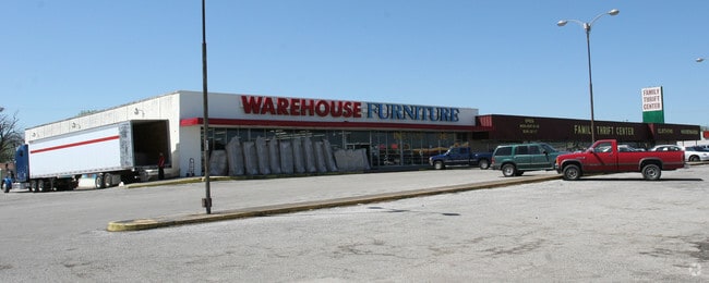
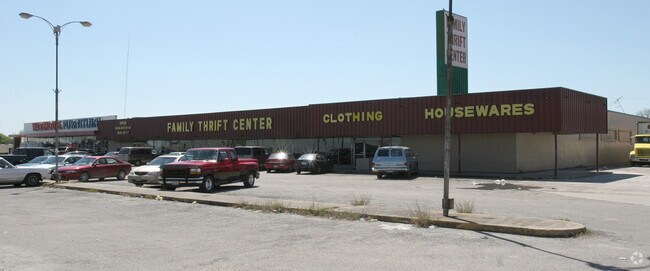
Property Record
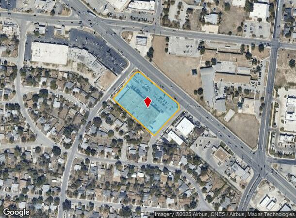
805 Bandera Rd, San Antonio, TX 78228
NEARBY LISTINGS FOR SALE OR LEASE
Property Detail
805 Bandera Rd
San Antonio-New Braunfels, TX
University Park Sub Bl 9594 Un
09594-034-0150
NCB 9594 BLK 34 LOT S 232 FT OF 9
Storebuilding
Bexar
X
Texas
48029C0383H
15
2024
2.46 AC
2025
Northwest
170600
San Antonio
38,665 SF
DEMOGRAPHICS near 805 Bandera Rd
1 Mile
3 Mile
5 Mile
2024 Total Population
15,528
155,326
369,647
2029 Population
16,373
164,298
392,773
Pop Growth 2024-2029
+ 5.44%
+ 5.78%
+ 6.26%
Average Age
39
38
38
2024 Total Households
5,478
54,380
141,907
HH Growth 2024-2029
+ 5.55%
+ 5.98%
+ 6.67%
Median Household Inc
$43,644
$38,248
$42,604
Avg Household Size
2.70
2.80
2.50
2024 Avg HH Vehicles
2.00
2.00
2.00
Median Home Value
$136,509
$133,734
$153,137
Median Year Built
1957
1959
1969
Nearby Places
Map Layers
Map Styles
 Street
 Aerial
- Restaurants
- Banks
- Shops
- Fitness
- Groceries
PUBLIC TRANSPORTATION
COMMUTER RAIL
San Antonio Amtrak Station (Sunset Limited - Amtrak, Texas Eagle - Amtrak)
DRIVE
WALK
Distance
San Antonio Amtrak Station (Sunset Limited - Amtrak, Texas Eagle - Amtrak)
11 min
6.0 mi
AIRPORT
San Antonio International
DRIVE
WALK
Distance
San Antonio International
15 min
9.8 mi
Freight Ports
Calhoun Port
DRIVE
WALK
Distance
Calhoun Port
188 min
153.4 mi
Nearby Properties
Address
Land Use
TOTAL SIZE
Lot Size
Zoning
Address
Land Use
TOTAL SIZE
Lot Size
Zoning
324,044 SF
16.87 AC
Address
Land Use
TOTAL SIZE
Lot Size
Zoning
326,820 SF
12.57 AC
Address
Land Use
TOTAL SIZE
Lot Size
Zoning
122,292 SF
12.83 AC
Address
Land Use
TOTAL SIZE
Lot Size
Zoning
138,674 SF
11.14 AC
Address
Land Use
TOTAL SIZE
Lot Size
Zoning
245,371 SF
20.50 AC
Address
Land Use
TOTAL SIZE
Lot Size
Zoning
Address
Land Use
TOTAL SIZE
Lot Size
Zoning
186,948 SF
9.58 AC
Address
Land Use
TOTAL SIZE
Lot Size
Zoning
110,468 SF
6.82 AC
Address
Land Use
TOTAL SIZE
Lot Size
Zoning
Address
Land Use
TOTAL SIZE
Lot Size
Zoning
223,148 SF
19.15 AC
Address
Land Use
TOTAL SIZE
Lot Size
Zoning
99,538 SF
11.89 AC
Address
Land Use
TOTAL SIZE
Lot Size
Zoning
102,456 SF
7.35 AC
Address
Land Use
TOTAL SIZE
Lot Size
Zoning
173,363 SF
10.29 AC
Address
Land Use
TOTAL SIZE
Lot Size
Zoning
315,630 SF
10.19 AC
Address
Land Use
TOTAL SIZE
Lot Size
Zoning
841,948 SF
27.14 AC
Address
Land Use
TOTAL SIZE
Lot Size
Zoning
195,422 SF
8.39 AC
Address
Land Use
TOTAL SIZE
Lot Size
Zoning
125,776 SF
6.98 AC
Address
Land Use
TOTAL SIZE
Lot Size
Zoning
222,558 SF
6.36 AC
Address
Land Use
TOTAL SIZE
Lot Size
Zoning
104,983 SF
2.86 AC
Address
Land Use
TOTAL SIZE
Lot Size
Zoning
148,206 SF
7.69 AC
Address
Land Use
TOTAL SIZE
Lot Size
Zoning
221,761 SF
8.77 AC
Address
Land Use
TOTAL SIZE
Lot Size
Zoning
32.06 AC
Address
Land Use
TOTAL SIZE
Lot Size
Zoning
179,276 SF
20.19 AC
Address
Land Use
TOTAL SIZE
Lot Size
Zoning
143,212 SF
14.85 AC
Address
Land Use
TOTAL SIZE
Lot Size
Zoning
245,574 SF
19.65 AC
Address
Land Use
TOTAL SIZE
Lot Size
Zoning
133,892 SF
7.41 AC
Address
Land Use
TOTAL SIZE
Lot Size
Zoning
155,130 SF
13.89 AC
Address
Land Use
TOTAL SIZE
Lot Size
Zoning
222,095 SF
10.01 AC
Address
Land Use
TOTAL SIZE
Lot Size
Zoning
122,778 SF
11.27 AC
Address
Land Use
TOTAL SIZE
Lot Size
Zoning
150,500 SF
5.12 AC
The World's #1 Commercial Real Estate Marketplace
Connect with us
© 2025 CoStar Group
The information above has been obtained from sources believed reliable. While we do not doubt its accuracy we have not verified it and make no guarantee, warranty or representation about it. It is your responsibility to independently confirm its accuracy and completeness. Any projections, opinions, assumptions, or estimates used are for example only and do not represent the current or future performance of the property. The value of this transaction to you depends on tax and other factors which should be evaluated by your tax, financial, and legal advisors. You and your advisors should conduct a careful, independent investigation of the property to determine to your satisfaction the suitability of the property for your needs.