Property Record
806 S White Sands Blvd, Alamogordo, NM 88310


Property Detail
806 S White Sands Blvd
R023409
SUBD: SOUTH WHITE SANDS #1 REPLAT LOT 1A-2
Restaurantbuilding
Otero
C-3
New Mexico
B and X Area of moderate flood hazard, usually the area between the limits of the 100-year and 500-year floods.
1a,1a-2
2025
1.22 AC
2025
Las Cruces/Alamogordo
000404
Other Market Areas
4,398 SF
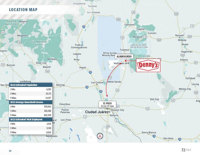
Alamogordo, NM
NEARBY LISTINGS FOR SALE OR LEASE
DEMOGRAPHICS near 806 S White Sands Blvd
1 mile
3 mile
5 mile
2025 Total Population
4,238
27,808
32,272
2030 Population
4,301
28,008
32,481
Pop Growth 2025-2030
+ 1.49%
+ 0.72%
+ 0.65%
Average Age
38
40
40
2025 Total Households
1,768
11,961
13,850
HH Growth 2025-2030
+ 1.07%
+ 0.57%
+ 0.48%
Median Household Inc
$59,935
$50,195
$51,975
Avg Household Size
2.20
2.20
2.20
2025 Avg HH Vehicles
2.00
2.00
2.00
Median Home Value
$197,259
$168,770
$175,296
Median Year Built
1990
1976
1979
Nearby Places
Map Layers
Map Styles
 Street
 Aerial
Layers
 Traffic
 Biking
Places
Listings with unknown addresses are not visible on the map
- Restaurants
- Banks
- Shops
- Fitness
- Groceries
SALE & LEASE HISTORY
LISTING DATE
SALE/LEASE

Nov 02, 2022
For Sale
Nearby Properties
Address
Land Use
TOTAL SIZE
Lot Size
Zoning
Address
Land Use
TOTAL SIZE
Lot Size
Zoning
5,378 SF
18.65 AC
C-3
Address
Land Use
TOTAL SIZE
Lot Size
Zoning
7,534 SF
66.27 AC
R-1
Address
Land Use
TOTAL SIZE
Lot Size
Zoning
21,306 SF
8.85 AC
R-1
Address
Land Use
TOTAL SIZE
Lot Size
Zoning
33.74 AC
R-1
Address
Land Use
TOTAL SIZE
Lot Size
Zoning
76,539 SF
8.24 AC
R-1
Address
Land Use
TOTAL SIZE
Lot Size
Zoning
211,757 SF
4.86 AC
Address
Land Use
TOTAL SIZE
Lot Size
Zoning
22,893 SF
2.18 AC
C-3
Address
Land Use
TOTAL SIZE
Lot Size
Zoning
56,121 SF
1.81 AC
C-3
Address
Land Use
TOTAL SIZE
Lot Size
Zoning
6,928 SF
30.66 AC
R-1
Address
Land Use
TOTAL SIZE
Lot Size
Zoning
53,799 SF
3.97 AC
C-3
Address
Land Use
TOTAL SIZE
Lot Size
Zoning
42,104 SF
6.70 AC
C-3
Address
Land Use
TOTAL SIZE
Lot Size
Zoning
32,430 SF
1.81 AC
C-3
Address
Land Use
TOTAL SIZE
Lot Size
Zoning
39,856 SF
1.97 AC
C-3
Address
Land Use
TOTAL SIZE
Lot Size
Zoning
2,440 SF
22.25 AC
M-2
Address
Land Use
TOTAL SIZE
Lot Size
Zoning
20,889 SF
3.12 AC
C-3
Address
Land Use
TOTAL SIZE
Lot Size
Zoning
40,607 SF
3.06 AC
M-2
Address
Land Use
TOTAL SIZE
Lot Size
Zoning
45,123 SF
2.03 AC
C-3
Address
Land Use
TOTAL SIZE
Lot Size
Zoning
54,880 SF
5.17 AC
C-3
Address
Land Use
TOTAL SIZE
Lot Size
Zoning
2,304 SF
4.19 AC
C-3
Address
Land Use
TOTAL SIZE
Lot Size
Zoning
46,761 SF
2.42 AC
C-3
Address
Land Use
TOTAL SIZE
Lot Size
Zoning
126,688 SF
19.62 AC
R-1
Address
Land Use
TOTAL SIZE
Lot Size
Zoning
1,064 SF
15.91 AC
Address
Land Use
TOTAL SIZE
Lot Size
Zoning
11,240 SF
125.04 AC
R-1
Address
Land Use
TOTAL SIZE
Lot Size
Zoning
4,768 SF
4 AC
R-1
Address
Land Use
TOTAL SIZE
Lot Size
Zoning
26,215 SF
5.04 AC
C-3
Address
Land Use
TOTAL SIZE
Lot Size
Zoning
1,400 SF
2.92 AC
C-3
Address
Land Use
TOTAL SIZE
Lot Size
Zoning
36,300 SF
1.28 AC
C-3
Address
Land Use
TOTAL SIZE
Lot Size
Zoning
29,050 SF
3 AC
C-1
Address
Land Use
TOTAL SIZE
Lot Size
Zoning
5,814 SF
2.86 AC
C-3
Address
Land Use
TOTAL SIZE
Lot Size
Zoning
25,464 SF
3.89 AC
C-3
The World's #1 Commercial Real Estate Marketplace
Connect with us
© 2026 CoStar Group
The information above has been obtained from sources believed reliable. While we do not doubt its accuracy we have not verified it and make no guarantee, warranty or representation about it. It is your responsibility to independently confirm its accuracy and completeness. Any projections, opinions, assumptions, or estimates used are for example only and do not represent the current or future performance of the property. The value of this transaction to you depends on tax and other factors which should be evaluated by your tax, financial, and legal advisors. You and your advisors should conduct a careful, independent investigation of the property to determine to your satisfaction the suitability of the property for your needs.