Property Record
807 10Th St, Great Bend, KS 67530


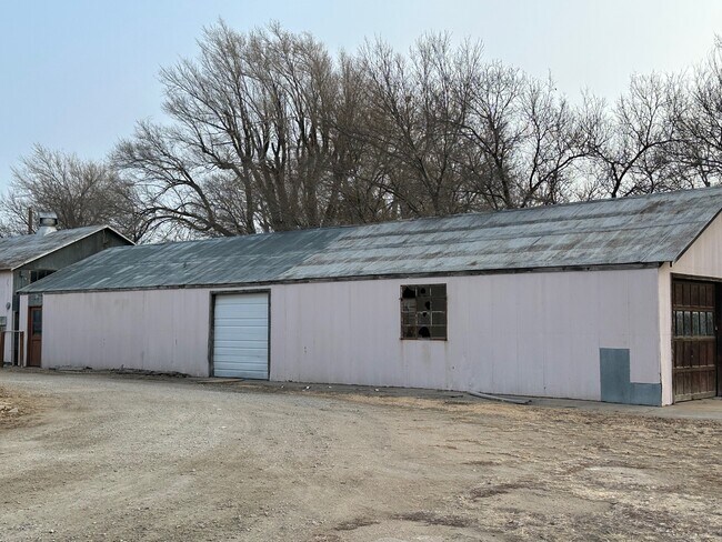
Property Detail
807 10Th St
188-34-0-20-01-002.00-0
GREAT BEND UNNUMBERED TRACT 14, S34, T19, R13W, PARCEL SIZE-200'X300'; COM 130 W & 40 S NECOR NW/4 TH W200,S300,E200,N300 POB
Restaurantbuilding
Barton
M
Kansas
C and X Area of minimal flood hazard, usually depicted on FIRMs as above the 500-year flood level.
1.40 AC
2025
Kansas Area
2025
Other Market Areas
971801
Great Bend, KS
3,200 SF
NEARBY LISTINGS FOR SALE OR LEASE
DEMOGRAPHICS near 807 10Th St
1 mile
3 mile
5 mile
2025 Total Population
3,794
12,823
16,427
2030 Population
3,936
12,699
16,210
Pop Growth 2025-2030
+ 3.74%
(0.97%)
(1.32%)
Average Age
36
40
41
2025 Total Households
1,369
5,264
6,782
HH Growth 2025-2030
+ 3.87%
(1.08%)
(1.39%)
Median Household Inc
$40,393
$52,693
$56,340
Avg Household Size
2.60
2.30
2.30
2025 Avg HH Vehicles
2.00
2.00
2.00
Median Home Value
$87,975
$131,139
$144,981
Median Year Built
1966
1956
1959
Nearby Places
Map Layers
Map Styles
 Street
 Aerial
Layers
 Traffic
 Biking
Places
Listings with unknown addresses are not visible on the map
- Restaurants
- Banks
- Shops
- Fitness
- Groceries
SALE & LEASE HISTORY
LISTING DATE
SALE/LEASE

Jan 24, 2023
For Sale
Nearby Properties
Address
Land Use
TOTAL SIZE
Lot Size
Zoning
Address
Land Use
TOTAL SIZE
Lot Size
Zoning
202,147 SF
15 AC
Address
Land Use
TOTAL SIZE
Lot Size
Zoning
35,380 SF
7.74 AC
Address
Land Use
TOTAL SIZE
Lot Size
Zoning
77,184 SF
0.64 AC
Address
Land Use
TOTAL SIZE
Lot Size
Zoning
105,204 SF
10.90 AC
Address
Land Use
TOTAL SIZE
Lot Size
Zoning
3,290 SF
0.93 AC
Address
Land Use
TOTAL SIZE
Lot Size
Zoning
41,139 SF
14.50 AC
NR03
Address
Land Use
TOTAL SIZE
Lot Size
Zoning
20,100 SF
1.16 AC
Address
Land Use
TOTAL SIZE
Lot Size
Zoning
68,645 SF
2.46 AC
Address
Land Use
TOTAL SIZE
Lot Size
Zoning
17,835 SF
6.70 AC
Address
Land Use
TOTAL SIZE
Lot Size
Zoning
15,775 SF
3.70 AC
NR06
Address
Land Use
TOTAL SIZE
Lot Size
Zoning
48,792 SF
4.60 AC
Address
Land Use
TOTAL SIZE
Lot Size
Zoning
47,890 SF
2.07 AC
Address
Land Use
TOTAL SIZE
Lot Size
Zoning
32,977 SF
2 AC
Address
Land Use
TOTAL SIZE
Lot Size
Zoning
3,600 SF
45.10 AC
Address
Land Use
TOTAL SIZE
Lot Size
Zoning
9,678 SF
2.60 AC
Address
Land Use
TOTAL SIZE
Lot Size
Zoning
71,152 SF
18.16 AC
Address
Land Use
TOTAL SIZE
Lot Size
Zoning
213,965 SF
13.10 AC
Address
Land Use
TOTAL SIZE
Lot Size
Zoning
86,860 SF
75.50 AC
Address
Land Use
TOTAL SIZE
Lot Size
Zoning
31,745 SF
5.79 AC
Address
Land Use
TOTAL SIZE
Lot Size
Zoning
41,844 SF
2.35 AC
Address
Land Use
TOTAL SIZE
Lot Size
Zoning
47,928 SF
2.50 AC
Y
Address
Land Use
TOTAL SIZE
Lot Size
Zoning
24,500 SF
2.93 AC
Address
Land Use
TOTAL SIZE
Lot Size
Zoning
27,400 SF
1.96 AC
Address
Land Use
TOTAL SIZE
Lot Size
Zoning
7,540 SF
1.10 AC
Address
Land Use
TOTAL SIZE
Lot Size
Zoning
31,001 SF
3.30 AC
Address
Land Use
TOTAL SIZE
Lot Size
Zoning
2,989 SF
4.90 AC
Address
Land Use
TOTAL SIZE
Lot Size
Zoning
32,330 SF
3.80 AC
Address
Land Use
TOTAL SIZE
Lot Size
Zoning
25,865 SF
0.69 AC
Address
Land Use
TOTAL SIZE
Lot Size
Zoning
20,315 SF
1.46 AC
Address
Land Use
TOTAL SIZE
Lot Size
Zoning
20,715 SF
2.73 AC
The World's #1 Commercial Real Estate Marketplace
Connect with us
© 2026 CoStar Group
The information above has been obtained from sources believed reliable. While we do not doubt its accuracy we have not verified it and make no guarantee, warranty or representation about it. It is your responsibility to independently confirm its accuracy and completeness. Any projections, opinions, assumptions, or estimates used are for example only and do not represent the current or future performance of the property. The value of this transaction to you depends on tax and other factors which should be evaluated by your tax, financial, and legal advisors. You and your advisors should conduct a careful, independent investigation of the property to determine to your satisfaction the suitability of the property for your needs.