Property Record
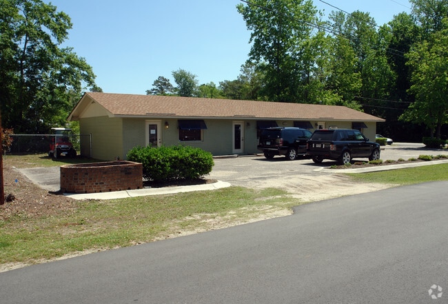
810 6Th Ave S, Surfside Beach, SC 29575


NEARBY LISTINGS FOR SALE OR LEASE
Property Detail
810 6Th Ave S
46108010013
Highway Section Of Surfside Beach
Officebuilding
HWY SECT
X
Horry
45051C0801K
South Carolina
2025
0.19 AC
2024
Outlying Horry County
051202
Myrtle Beach/Conway
2,207 SF
Myrtle Beach-Conway-North Myrtle Beach, SC
DEMOGRAPHICS near 810 6Th Ave S
1 mile
3 mile
5 mile
2024 Total Population
10,260
38,714
84,100
2029 Population
12,897
47,846
102,256
Pop Growth 2024-2029
+ 25.70%
+ 23.59%
+ 21.59%
Average Age
52
52
50
2024 Total Households
5,041
18,388
38,563
HH Growth 2024-2029
+ 24.46%
+ 22.41%
+ 20.48%
Median Household Inc
$56,813
$59,468
$57,644
Avg Household Size
2.00
2.00
2.10
2024 Avg HH Vehicles
2.00
2.00
2.00
Median Home Value
$256,807
$239,074
$244,636
Median Year Built
1988
1990
1996
Nearby Places
Map Layers
Map Styles
 Street
 Aerial
Transit
 Traffic
 Biking
Places
Listings with unknown addresses are not visible on the map
- Restaurants
- Banks
- Shops
- Fitness
- Groceries
PUBLIC TRANSPORTATION
AIRPORT
Myrtle Beach International
Drive
Walk
Distance
Myrtle Beach International
15 min
7.4 mi
Nearby Properties
Address
Land Use
TOTAL SIZE
Lot Size
Zoning
Address
Land Use
TOTAL SIZE
Lot Size
Zoning
17,640 SF
240.91 AC
Address
Land Use
TOTAL SIZE
Lot Size
Zoning
9,190 SF
85.15 AC
Address
Land Use
TOTAL SIZE
Lot Size
Zoning
9,772 SF
130.49 AC
Address
Land Use
TOTAL SIZE
Lot Size
Zoning
28,959 SF
31.56 AC
Address
Land Use
TOTAL SIZE
Lot Size
Zoning
496.81 AC
Address
Land Use
TOTAL SIZE
Lot Size
Zoning
3,696 SF
55.20 AC
Address
Land Use
TOTAL SIZE
Lot Size
Zoning
7,144 SF
187.64 AC
Address
Land Use
TOTAL SIZE
Lot Size
Zoning
1,300 SF
55.48 AC
Address
Land Use
TOTAL SIZE
Lot Size
Zoning
151,727 SF
21.25 AC
Address
Land Use
TOTAL SIZE
Lot Size
Zoning
636.82 AC
Address
Land Use
TOTAL SIZE
Lot Size
Zoning
39,275 SF
14.37 AC
Address
Land Use
TOTAL SIZE
Lot Size
Zoning
2,510 SF
43.14 AC
Address
Land Use
TOTAL SIZE
Lot Size
Zoning
194,035 SF
26.79 AC
Address
Land Use
TOTAL SIZE
Lot Size
Zoning
25,722 SF
13.73 AC
Address
Land Use
TOTAL SIZE
Lot Size
Zoning
46.79 AC
Address
Land Use
TOTAL SIZE
Lot Size
Zoning
4,800 SF
75.54 AC
Address
Land Use
TOTAL SIZE
Lot Size
Zoning
57,216 SF
2.36 AC
Address
Land Use
TOTAL SIZE
Lot Size
Zoning
132,091 SF
14.03 AC
Address
Land Use
TOTAL SIZE
Lot Size
Zoning
65,578 SF
12.12 AC
Address
Land Use
TOTAL SIZE
Lot Size
Zoning
18,816 SF
10.17 AC
Address
Land Use
TOTAL SIZE
Lot Size
Zoning
33,862 SF
9.98 AC
Address
Land Use
TOTAL SIZE
Lot Size
Zoning
28,278 SF
50.53 AC
Address
Land Use
TOTAL SIZE
Lot Size
Zoning
42,768 SF
10.40 AC
Address
Land Use
TOTAL SIZE
Lot Size
Zoning
8,012 SF
7.40 AC
Address
Land Use
TOTAL SIZE
Lot Size
Zoning
74,389 SF
1.90 AC
Address
Land Use
TOTAL SIZE
Lot Size
Zoning
49.53 AC
Address
Land Use
TOTAL SIZE
Lot Size
Zoning
6,728 SF
35.71 AC
The World's #1 Commercial Real Estate Marketplace
Connect with us
© 2026 CoStar Group
The information above has been obtained from sources believed reliable. While we do not doubt its accuracy we have not verified it and make no guarantee, warranty or representation about it. It is your responsibility to independently confirm its accuracy and completeness. Any projections, opinions, assumptions, or estimates used are for example only and do not represent the current or future performance of the property. The value of this transaction to you depends on tax and other factors which should be evaluated by your tax, financial, and legal advisors. You and your advisors should conduct a careful, independent investigation of the property to determine to your satisfaction the suitability of the property for your needs.