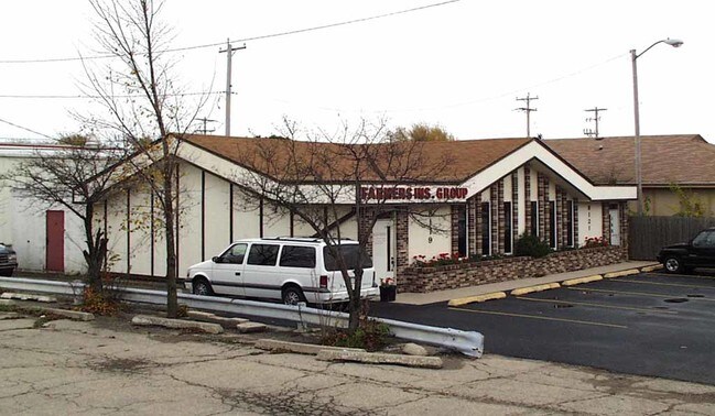
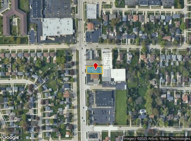
Property Record
8119 22Nd Ave, Kenosha, WI 53143
NEARBY LISTINGS FOR SALE OR LEASE
Property Detail
8119 22Nd Ave
06-123-07-330-020
PT SW 1/4 SEC 7 T 1 R 23 BEG 878.63 FT S OF NW COR 1/4 SEC TH E 183 FT S 65 FT W 183 FT N 65 FT TO BEG EXC 40 FT FOR STR DOC#
Commercialnec
Kenosha
X
Wisconsin
55059C0212E
20
2024
0.21 AC
2024
Kenosha East
002100
Chicago
2,750 SF
Chicago-Naperville-Elgin, IL-IN-WI
DEMOGRAPHICS near 8119 22Nd Ave
1 Mile
3 Mile
5 Mile
2024 Total Population
13,774
69,723
110,016
2029 Population
13,631
68,670
108,879
Pop Growth 2024-2029
(1.04%)
(1.51%)
(1.03%)
Average Age
40
39
40
2024 Total Households
5,604
27,591
43,434
HH Growth 2024-2029
(1.07%)
(1.57%)
(1.01%)
Median Household Inc
$65,036
$63,990
$67,510
Avg Household Size
2.40
2.40
2.40
2024 Avg HH Vehicles
2.00
2.00
2.00
Median Home Value
$163,382
$190,117
$211,616
Median Year Built
1960
1961
1970
Nearby Places
Map Layers
Map Styles
 Street
 Aerial
- Restaurants
- Banks
- Shops
- Fitness
- Groceries
PUBLIC TRANSPORTATION
COMMUTER RAIL
Kenosha Station (Union Pacific North Line - Northeast Illinois Regional Commuter Railroad (Metra))
DRIVE
WALK
Distance
Kenosha Station (Union Pacific North Line - Northeast Illinois Regional Commuter Railroad (Metra))
6 min
2.8 mi
Winthrop Harbor Station (Union Pacific North Line - Northeast Illinois Regional Commuter Railroad (Metra))
DRIVE
WALK
Distance
Winthrop Harbor Station (Union Pacific North Line - Northeast Illinois Regional Commuter Railroad (Metra))
13 min
6.0 mi
AIRPORT
General Mitchell International
DRIVE
WALK
Distance
General Mitchell International
47 min
34.7 mi
Freight Ports
Port Milwaukee
DRIVE
WALK
Distance
Port Milwaukee
51 min
38.6 mi
Nearby Properties
Address
Land Use
TOTAL SIZE
Lot Size
Zoning
Address
Land Use
TOTAL SIZE
Lot Size
Zoning
35,092 SF
26.34 AC
B2
Address
Land Use
TOTAL SIZE
Lot Size
Zoning
194,281 SF
19.13 AC
B2
Address
Land Use
TOTAL SIZE
Lot Size
Zoning
10.37 AC
IP
Address
Land Use
TOTAL SIZE
Lot Size
Zoning
357,885 SF
26.58 AC
M1
Address
Land Use
TOTAL SIZE
Lot Size
Zoning
76,848 SF
8.09 AC
BASE
Address
Land Use
TOTAL SIZE
Lot Size
Zoning
28,815 SF
1.04 AC
B3
Address
Land Use
TOTAL SIZE
Lot Size
Zoning
17,174 SF
10.31 AC
RS2
Address
Land Use
TOTAL SIZE
Lot Size
Zoning
0.62 AC
Address
Land Use
TOTAL SIZE
Lot Size
Zoning
67,850 SF
5.51 AC
B2
Address
Land Use
TOTAL SIZE
Lot Size
Zoning
63,500 SF
5.81 AC
RM2
Address
Land Use
TOTAL SIZE
Lot Size
Zoning
147,040 SF
2.50 AC
RM2
Address
Land Use
TOTAL SIZE
Lot Size
Zoning
92,358 SF
8.72 AC
B2
Address
Land Use
TOTAL SIZE
Lot Size
Zoning
39.98 AC
BASE
Address
Land Use
TOTAL SIZE
Lot Size
Zoning
10,856 SF
7.95 AC
Address
Land Use
TOTAL SIZE
Lot Size
Zoning
71,277 SF
14.28 AC
B2
Address
Land Use
TOTAL SIZE
Lot Size
Zoning
1,200 SF
17.69 AC
Address
Land Use
TOTAL SIZE
Lot Size
Zoning
135,468 SF
13.56 AC
B2
Address
Land Use
TOTAL SIZE
Lot Size
Zoning
60,657 SF
4.42 AC
RM3
Address
Land Use
TOTAL SIZE
Lot Size
Zoning
61,318 SF
6.17 AC
B2
Address
Land Use
TOTAL SIZE
Lot Size
Zoning
88,867 SF
8.32 AC
B2
Address
Land Use
TOTAL SIZE
Lot Size
Zoning
11,568 SF
5.96 AC
RM2
Address
Land Use
TOTAL SIZE
Lot Size
Zoning
80,684 SF
7.05 AC
B2
Address
Land Use
TOTAL SIZE
Lot Size
Zoning
116,227 SF
10.60 AC
B2
Address
Land Use
TOTAL SIZE
Lot Size
Zoning
21,060 SF
7.02 AC
RM2
Address
Land Use
TOTAL SIZE
Lot Size
Zoning
21,060 SF
7.08 AC
RM2
Address
Land Use
TOTAL SIZE
Lot Size
Zoning
41,047 SF
4.21 AC
RM3
Address
Land Use
TOTAL SIZE
Lot Size
Zoning
6.03 AC
M2
Address
Land Use
TOTAL SIZE
Lot Size
Zoning
25,164 SF
3.21 AC
RM2
Address
Land Use
TOTAL SIZE
Lot Size
Zoning
89,436 SF
4.53 AC
RM2
Address
Land Use
TOTAL SIZE
Lot Size
Zoning
20,264 SF
5.73 AC
RM2
The World's #1 Commercial Real Estate Marketplace
Connect with us
© 2025 CoStar Group
The information above has been obtained from sources believed reliable. While we do not doubt its accuracy we have not verified it and make no guarantee, warranty or representation about it. It is your responsibility to independently confirm its accuracy and completeness. Any projections, opinions, assumptions, or estimates used are for example only and do not represent the current or future performance of the property. The value of this transaction to you depends on tax and other factors which should be evaluated by your tax, financial, and legal advisors. You and your advisors should conduct a careful, independent investigation of the property to determine to your satisfaction the suitability of the property for your needs.