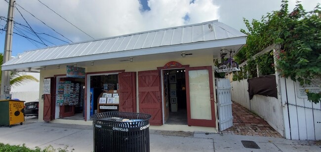
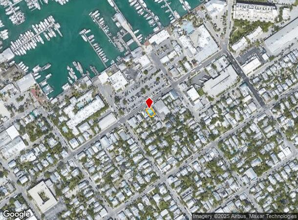
Property Record
812 Caroline St, Key West, FL 33040
NEARBY LISTINGS FOR SALE OR LEASE
Property Detail
812 Caroline St
Key West, FL
Key West Square 21
00003150-000000
KW PT LOT 3 SQR 21 H3-211 OR995-2045 OR1060-2136 OR1432-2104 OR1442-2179/80 OR2093-2409/10 OR2392-128/30 OR2492-802/04
Commercialofficeresidentialmixeduse
Monroe
AE
Florida
12087C1516K
3
2024
0.05 AC
2025
Key West
972500
Other Market Areas
1,176 SF
DEMOGRAPHICS near 812 Caroline St
1 Mile
3 Mile
5 Mile
2024 Total Population
7,761
20,273
27,068
2029 Population
7,442
19,393
25,787
Pop Growth 2024-2029
(4.11%)
(4.34%)
(4.73%)
Average Age
48
44
43
2024 Total Households
3,928
8,834
11,363
HH Growth 2024-2029
(4.25%)
(4.61%)
(4.95%)
Median Household Inc
$70,105
$72,762
$71,997
Avg Household Size
1.90
2.20
2.20
2024 Avg HH Vehicles
1.00
1.00
1.00
Median Home Value
$807,884
$747,491
$726,850
Median Year Built
1953
1967
1972
Nearby Places
Map Layers
Map Styles
 Street
 Aerial
- Restaurants
- Banks
- Shops
- Fitness
- Groceries
PUBLIC TRANSPORTATION
AIRPORT
Key West International
DRIVE
WALK
Distance
Key West International
9 min
2.8 mi
Freight Ports
Port of Miami
DRIVE
WALK
Distance
Port of Miami
251 min
165.8 mi
SALE & LEASE HISTORY
LISTING DATE
SALE/LEASE

Nov 11, 2020
For Sale
Nearby Properties
Address
Land Use
TOTAL SIZE
Lot Size
Zoning
Address
Land Use
TOTAL SIZE
Lot Size
Zoning
98,815 SF
341.08 AC
M
Address
Land Use
TOTAL SIZE
Lot Size
Zoning
306.55 AC
M
Address
Land Use
TOTAL SIZE
Lot Size
Zoning
83.22 AC
HPRD
Address
Land Use
TOTAL SIZE
Lot Size
Zoning
105.78 AC
COW
Address
Land Use
TOTAL SIZE
Lot Size
Zoning
6.29 AC
HRCC2
Address
Land Use
TOTAL SIZE
Lot Size
Zoning
311,480 SF
8.57 AC
HCT
Address
Land Use
TOTAL SIZE
Lot Size
Zoning
291,300 SF
4.15 AC
HPRD
Address
Land Use
TOTAL SIZE
Lot Size
Zoning
58,091 SF
4.87 AC
CT
Address
Land Use
TOTAL SIZE
Lot Size
Zoning
106,800 SF
1.46 AC
HRCC1
Address
Land Use
TOTAL SIZE
Lot Size
Zoning
24,704 SF
2.42 AC
HRCC1
Address
Land Use
TOTAL SIZE
Lot Size
Zoning
53,173 SF
3.11 AC
HCT
Address
Land Use
TOTAL SIZE
Lot Size
Zoning
963 SF
16.94 AC
HPS
Address
Land Use
TOTAL SIZE
Lot Size
Zoning
121,188 SF
4.75 AC
HRCC1
Address
Land Use
TOTAL SIZE
Lot Size
Zoning
83,684 SF
3.22 AC
HCT
Address
Land Use
TOTAL SIZE
Lot Size
Zoning
115,501 SF
96.47 AC
Address
Land Use
TOTAL SIZE
Lot Size
Zoning
55,274 SF
2.87 AC
HCT
Address
Land Use
TOTAL SIZE
Lot Size
Zoning
22,387 SF
57.30 AC
M
Address
Land Use
TOTAL SIZE
Lot Size
Zoning
13,452 SF
4.38 AC
HPRD
Address
Land Use
TOTAL SIZE
Lot Size
Zoning
147,707 SF
6.24 AC
MDR
Address
Land Use
TOTAL SIZE
Lot Size
Zoning
90,585 SF
2 AC
CG
Address
Land Use
TOTAL SIZE
Lot Size
Zoning
222,433 SF
25.69 AC
PS
Address
Land Use
TOTAL SIZE
Lot Size
Zoning
13,174 SF
38.72 AC
HPRD
Address
Land Use
TOTAL SIZE
Lot Size
Zoning
232,414 SF
17.63 AC
CG
Address
Land Use
TOTAL SIZE
Lot Size
Zoning
37,890 SF
1.89 AC
HRCC1
Address
Land Use
TOTAL SIZE
Lot Size
Zoning
2,594 SF
22.38 AC
MDR
Address
Land Use
TOTAL SIZE
Lot Size
Zoning
189,418 SF
17.41 AC
CG
Address
Land Use
TOTAL SIZE
Lot Size
Zoning
178,252 SF
15.21 AC
CG
Address
Land Use
TOTAL SIZE
Lot Size
Zoning
63,145 SF
0.77 AC
HRCC1
Address
Land Use
TOTAL SIZE
Lot Size
Zoning
33,007 SF
24.18 AC
Address
Land Use
TOTAL SIZE
Lot Size
Zoning
51,953 SF
26.09 AC
HPS1
The World's #1 Commercial Real Estate Marketplace
Connect with us
© 2025 CoStar Group
The information above has been obtained from sources believed reliable. While we do not doubt its accuracy we have not verified it and make no guarantee, warranty or representation about it. It is your responsibility to independently confirm its accuracy and completeness. Any projections, opinions, assumptions, or estimates used are for example only and do not represent the current or future performance of the property. The value of this transaction to you depends on tax and other factors which should be evaluated by your tax, financial, and legal advisors. You and your advisors should conduct a careful, independent investigation of the property to determine to your satisfaction the suitability of the property for your needs.