Property Record
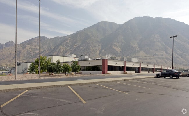
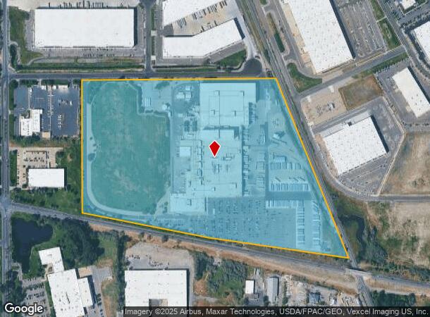
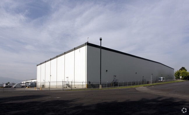
815 Raymond Klauck Way, Springville, UT 84663
NEARBY LISTINGS FOR SALE OR LEASE
Property Detail
815 Raymond Klauck Way
Provo-Orem, UT
COM S 320.95 FT & W 500.42 FT FR S 1/4 COR. SEC. 20, T7S, R3E SLB&M.; N 0 DEG 4 49 W 621.62 FT; N 0 DEG 4 53 W 505.33 FT; N 89 DEG 34 51 E 1650.9 FT; S 22 DEG 1 23 E 1643.79 FT; N 81 DEG 44 7 W 1198.96 FT; N 78 DEG 51 42 W 1099.87 FT TO BEG. AREA 59.
23-001-0060
Utah
Warehouse
Utah
2024
59.02 AC
2025
Utah County
980500
Salt Lake City
671,002 SF
DEMOGRAPHICS near 815 Raymond Klauck Way
1 Mile
3 Mile
5 Mile
2024 Total Population
2,372
43,482
133,682
2029 Population
2,766
50,661
156,236
Pop Growth 2024-2029
+ 16.61%
+ 16.51%
+ 16.87%
Average Age
31
32
30
2024 Total Households
668
13,143
40,756
HH Growth 2024-2029
+ 16.92%
+ 16.86%
+ 17.31%
Median Household Inc
$75,237
$73,979
$62,835
Avg Household Size
3.50
3.20
3.10
2024 Avg HH Vehicles
2.00
2.00
2.00
Median Home Value
$358,510
$385,329
$418,848
Median Year Built
1996
1994
1989
Nearby Places
Map Layers
Map Styles
 Street
 Aerial
- Restaurants
- Banks
- Shops
- Fitness
- Groceries
PUBLIC TRANSPORTATION
COMMUTER RAIL
Provo Central Station (FrontRunner - Utah Transit Authority (UTA))
DRIVE
WALK
Distance
Provo Central Station (FrontRunner - Utah Transit Authority (UTA))
10 min
4.6 mi
Provo Amtrak (California Zephyr - Amtrak)
DRIVE
WALK
Distance
Provo Amtrak (California Zephyr - Amtrak)
10 min
4.6 mi
AIRPORT
Provo Municipal
DRIVE
WALK
Distance
Provo Municipal
14 min
6.6 mi
Freight Ports
Port of Stockton
DRIVE
WALK
Distance
Port of Stockton
763 min
743.1 mi
Nearby Properties
Address
Land Use
TOTAL SIZE
Lot Size
Zoning
Address
Land Use
TOTAL SIZE
Lot Size
Zoning
442,598 SF
22.94 AC
Address
Land Use
TOTAL SIZE
Lot Size
Zoning
138,990 SF
2.87 AC
Address
Land Use
TOTAL SIZE
Lot Size
Zoning
297,467 SF
16.87 AC
Address
Land Use
TOTAL SIZE
Lot Size
Zoning
69,236 SF
30.28 AC
Address
Land Use
TOTAL SIZE
Lot Size
Zoning
286,188 SF
13.63 AC
Address
Land Use
TOTAL SIZE
Lot Size
Zoning
263,859 SF
12.80 AC
Address
Land Use
TOTAL SIZE
Lot Size
Zoning
269,742 SF
16.30 AC
Address
Land Use
TOTAL SIZE
Lot Size
Zoning
370,735 SF
18.54 AC
Address
Land Use
TOTAL SIZE
Lot Size
Zoning
222,848 SF
11.14 AC
Address
Land Use
TOTAL SIZE
Lot Size
Zoning
301,852 SF
20.24 AC
Address
Land Use
TOTAL SIZE
Lot Size
Zoning
208,492 SF
12.49 AC
Address
Land Use
TOTAL SIZE
Lot Size
Zoning
177,428 SF
9.83 AC
Address
Land Use
TOTAL SIZE
Lot Size
Zoning
210,644 SF
19.55 AC
Address
Land Use
TOTAL SIZE
Lot Size
Zoning
125,729 SF
12.84 AC
Address
Land Use
TOTAL SIZE
Lot Size
Zoning
29,819 SF
13.51 AC
Address
Land Use
TOTAL SIZE
Lot Size
Zoning
386,576 SF
128.19 AC
Address
Land Use
TOTAL SIZE
Lot Size
Zoning
240,674 SF
19.41 AC
Address
Land Use
TOTAL SIZE
Lot Size
Zoning
238,651 SF
14.45 AC
Address
Land Use
TOTAL SIZE
Lot Size
Zoning
124,986 SF
8.67 AC
Address
Land Use
TOTAL SIZE
Lot Size
Zoning
151,447 SF
16.14 AC
Address
Land Use
TOTAL SIZE
Lot Size
Zoning
141,566 SF
7.89 AC
Address
Land Use
TOTAL SIZE
Lot Size
Zoning
231,991 SF
13.76 AC
Address
Land Use
TOTAL SIZE
Lot Size
Zoning
79,260 SF
5.24 AC
Address
Land Use
TOTAL SIZE
Lot Size
Zoning
151,447 SF
8.61 AC
Address
Land Use
TOTAL SIZE
Lot Size
Zoning
195,248 SF
13.20 AC
Address
Land Use
TOTAL SIZE
Lot Size
Zoning
128,650 SF
10 AC
Address
Land Use
TOTAL SIZE
Lot Size
Zoning
120,613 SF
5.13 AC
Address
Land Use
TOTAL SIZE
Lot Size
Zoning
170,273 SF
9.19 AC
Address
Land Use
TOTAL SIZE
Lot Size
Zoning
265,411 SF
19.28 AC
The World's #1 Commercial Real Estate Marketplace
Connect with us
© 2026 CoStar Group
The information above has been obtained from sources believed reliable. While we do not doubt its accuracy we have not verified it and make no guarantee, warranty or representation about it. It is your responsibility to independently confirm its accuracy and completeness. Any projections, opinions, assumptions, or estimates used are for example only and do not represent the current or future performance of the property. The value of this transaction to you depends on tax and other factors which should be evaluated by your tax, financial, and legal advisors. You and your advisors should conduct a careful, independent investigation of the property to determine to your satisfaction the suitability of the property for your needs.