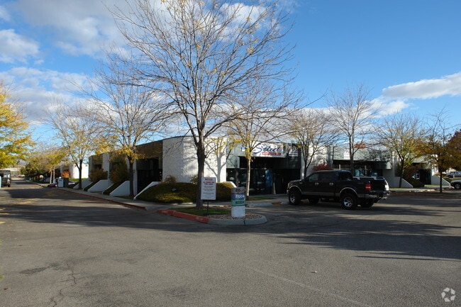
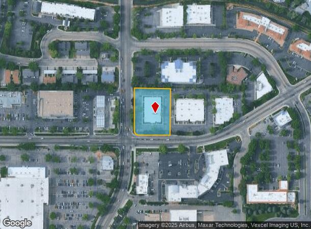
Property Record
8150 W Emerald St, Boise, ID 83704
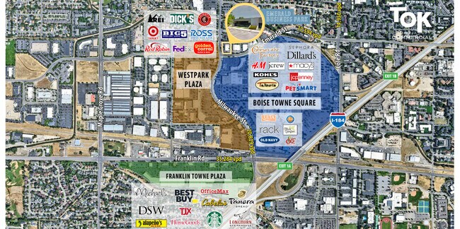
NEARBY LISTINGS FOR SALE OR LEASE
Property Detail
8150 W Emerald St
S1112427840
PAR #7840 @ NW COR SE4 SEC 12 3N 1E PAR A R/S 8912 #427842-S
Commercialnec
Ada
X
Idaho
16001C0260G
1.19 AC
2024
West Boise
2025
Boise City/Nampa
002319
Boise City, ID
12,000 SF
DEMOGRAPHICS near 8150 W Emerald St
1 Mile
3 Mile
5 Mile
2024 Total Population
13,211
102,787
266,014
2029 Population
14,912
115,822
301,271
Pop Growth 2024-2029
+ 12.88%
+ 12.68%
+ 13.25%
Average Age
38
40
40
2024 Total Households
5,504
41,475
108,438
HH Growth 2024-2029
+ 13.10%
+ 12.98%
+ 13.65%
Median Household Inc
$60,090
$63,719
$68,701
Avg Household Size
2.20
2.40
2.30
2024 Avg HH Vehicles
2.00
2.00
2.00
Median Home Value
$344,772
$377,803
$439,783
Median Year Built
1986
1984
1990
Nearby Places
Map Layers
Map Styles
 Street
 Aerial
- Restaurants
- Banks
- Shops
- Fitness
- Groceries
PUBLIC TRANSPORTATION
AIRPORT
Boise Air Trml/Gowen Field
DRIVE
WALK
Distance
Boise Air Trml/Gowen Field
15 min
6.9 mi
SALE & LEASE HISTORY
LISTING DATE
SALE/LEASE

Oct 20, 2021
For Lease
May 13, 2025
For Lease
Nearby Properties
Address
Land Use
TOTAL SIZE
Lot Size
Zoning
Address
Land Use
TOTAL SIZE
Lot Size
Zoning
646,787 SF
27.37 AC
ZC-243
Address
Land Use
TOTAL SIZE
Lot Size
Zoning
13.90 AC
R-2
Address
Land Use
TOTAL SIZE
Lot Size
Zoning
334,124 SF
11.21 AC
R-3
Address
Land Use
TOTAL SIZE
Lot Size
Zoning
4.02 AC
C-2/DA
Address
Land Use
TOTAL SIZE
Lot Size
Zoning
207,033 SF
10.67 AC
ZC-243
Address
Land Use
TOTAL SIZE
Lot Size
Zoning
225,032 SF
12.75 AC
R-3
Address
Land Use
TOTAL SIZE
Lot Size
Zoning
249,800 SF
12.99 AC
ZC-243
Address
Land Use
TOTAL SIZE
Lot Size
Zoning
319,052 SF
24.33 AC
ZC-243
Address
Land Use
TOTAL SIZE
Lot Size
Zoning
222,379 SF
1.37 AC
M
Address
Land Use
TOTAL SIZE
Lot Size
Zoning
211,039 SF
12.21 AC
ZC-243
Address
Land Use
TOTAL SIZE
Lot Size
Zoning
162,432 SF
8.31 AC
R-3
Address
Land Use
TOTAL SIZE
Lot Size
Zoning
72,579 SF
4.48 AC
ZC-269
Address
Land Use
TOTAL SIZE
Lot Size
Zoning
176,494 SF
10.16 AC
R-1C
Address
Land Use
TOTAL SIZE
Lot Size
Zoning
290,239 SF
4.73 AC
ZC-243
Address
Land Use
TOTAL SIZE
Lot Size
Zoning
166,184 SF
9.82 AC
ZC-269
Address
Land Use
TOTAL SIZE
Lot Size
Zoning
116,192 SF
7.14 AC
R-40
Address
Land Use
TOTAL SIZE
Lot Size
Zoning
292,885 SF
13.76 AC
C-1
Address
Land Use
TOTAL SIZE
Lot Size
Zoning
136,244 SF
8.56 AC
ZC-281
Address
Land Use
TOTAL SIZE
Lot Size
Zoning
118,345 SF
5.20 AC
R-2
Address
Land Use
TOTAL SIZE
Lot Size
Zoning
137,752 SF
5.13 AC
ZC-268
Address
Land Use
TOTAL SIZE
Lot Size
Zoning
127,136 SF
7.59 AC
R-3
Address
Land Use
TOTAL SIZE
Lot Size
Zoning
91,740 SF
3.63 AC
ZC-248
Address
Land Use
TOTAL SIZE
Lot Size
Zoning
161,259 SF
13.30 AC
ZC-243
Address
Land Use
TOTAL SIZE
Lot Size
Zoning
164,141 SF
24.32 AC
ZC-269
Address
Land Use
TOTAL SIZE
Lot Size
Zoning
323,236 SF
14.77 AC
ZC-269
Address
Land Use
TOTAL SIZE
Lot Size
Zoning
93,112 SF
2.73 AC
ZC-248
Address
Land Use
TOTAL SIZE
Lot Size
Zoning
218,215 SF
17.11 AC
ZC-248
Address
Land Use
TOTAL SIZE
Lot Size
Zoning
70,705 SF
0.63 AC
ZC-241
Address
Land Use
TOTAL SIZE
Lot Size
Zoning
130,560 SF
7.72 AC
R-2
Address
Land Use
TOTAL SIZE
Lot Size
Zoning
49,821 SF
5.45 AC
ZC-268
The World's #1 Commercial Real Estate Marketplace
Connect with us
© 2025 CoStar Group
The information above has been obtained from sources believed reliable. While we do not doubt its accuracy we have not verified it and make no guarantee, warranty or representation about it. It is your responsibility to independently confirm its accuracy and completeness. Any projections, opinions, assumptions, or estimates used are for example only and do not represent the current or future performance of the property. The value of this transaction to you depends on tax and other factors which should be evaluated by your tax, financial, and legal advisors. You and your advisors should conduct a careful, independent investigation of the property to determine to your satisfaction the suitability of the property for your needs.