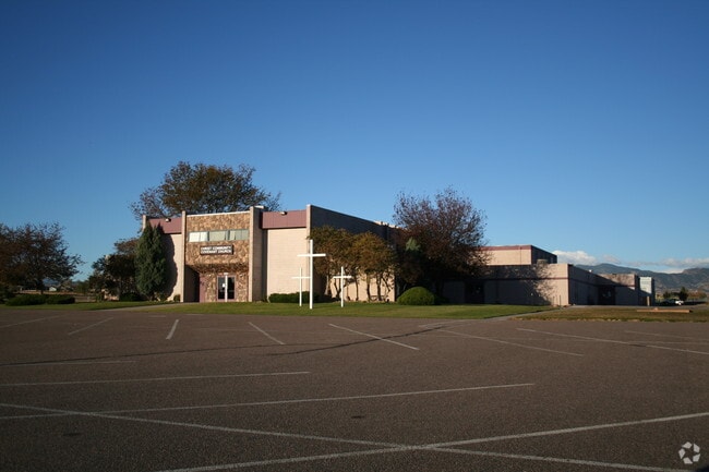
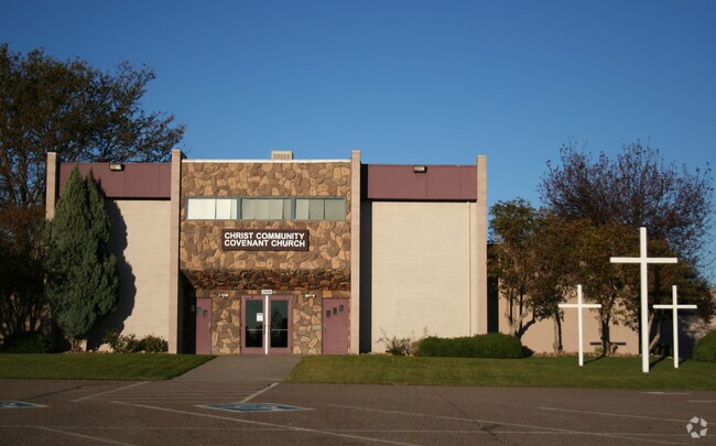
Property Record
8151 Simms St, Arvada, CO 80005

Property Detail
8151 Simms St
29-294-00-001
SECTION 29 TOWNSHIP 02 RANGE 69 QTR SE SIZE: 458643 VALUE: 10.529 KEY=013
Commercialnec
JEFFERSON
MR1
Colorado
B and X Area of moderate flood hazard, usually the area between the limits of the 100-year and 500-year floods.
10.53 AC
0
Northwest Denver
2024
Denver
009815
Denver-Aurora-Centennial, CO
28,308 SF
NEARBY LISTINGS FOR SALE OR LEASE
-
-
View all Arvada listings for sale on LoopNet.com
DEMOGRAPHICS near 8151 Simms St
1 mile
3 mile
5 mile
2024 Total Population
7,464
76,504
202,775
2029 Population
7,332
75,589
202,679
Pop Growth 2024-2029
(1.77%)
(1.20%)
(0.05%)
Average Age
44
43
41
2024 Total Households
2,760
29,962
82,099
HH Growth 2024-2029
(1.88%)
(1.33%)
(0.02%)
Median Household Inc
$152,787
$119,263
$106,423
Avg Household Size
2.70
2.50
2.40
2024 Avg HH Vehicles
3.00
2.00
2.00
Median Home Value
$753,465
$689,008
$670,159
Median Year Built
1987
1978
1980
Nearby Places
Map Layers
Map Styles
 Street
 Aerial
Transit
 Traffic
 Biking
Places
Listings with unknown addresses are not visible on the map
- Restaurants
- Banks
- Shops
- Fitness
- Groceries
PUBLIC TRANSPORTATION
COMMUTER RAIL
Arvada Ridge Station Track 1 (Union Station to Wheat Ridge Ward Station - Regional Transportation District)
Drive
Walk
Distance
Arvada Ridge Station Track 1 (Union Station to Wheat Ridge Ward Station - Regional Transportation District)
8 min
4.6 mi
Arvada Ridge Station Track 2 (Union Station to Wheat Ridge Ward Station - Regional Transportation District)
Drive
Walk
Distance
Arvada Ridge Station Track 2 (Union Station to Wheat Ridge Ward Station - Regional Transportation District)
8 min
4.7 mi
AIRPORT
Denver International
Drive
Walk
Distance
Denver International
45 min
34.0 mi
Freight Ports
Tulsa Port Of Catoosa
Drive
Walk
Distance
Tulsa Port Of Catoosa
742 min
719.5 mi
Nearby Properties
Address
Land Use
TOTAL SIZE
Lot Size
Zoning
Address
Land Use
TOTAL SIZE
Lot Size
Zoning
269,013 SF
31.89 AC
Address
Land Use
TOTAL SIZE
Lot Size
Zoning
253,643 SF
50.87 AC
A2
Address
Land Use
TOTAL SIZE
Lot Size
Zoning
215,878 SF
11.82 AC
A2
Address
Land Use
TOTAL SIZE
Lot Size
Zoning
559,786 SF
26.52 AC
Address
Land Use
TOTAL SIZE
Lot Size
Zoning
363,989 SF
30.10 AC
Address
Land Use
TOTAL SIZE
Lot Size
Zoning
101,761 SF
4.34 AC
Address
Land Use
TOTAL SIZE
Lot Size
Zoning
115,723 SF
24.06 AC
Address
Land Use
TOTAL SIZE
Lot Size
Zoning
162,509 SF
11.84 AC
Address
Land Use
TOTAL SIZE
Lot Size
Zoning
149,115 SF
18 AC
Address
Land Use
TOTAL SIZE
Lot Size
Zoning
253,558 SF
10.26 AC
A2
Address
Land Use
TOTAL SIZE
Lot Size
Zoning
248,096 SF
19.67 AC
Address
Land Use
TOTAL SIZE
Lot Size
Zoning
225,274 SF
5.37 AC
Address
Land Use
TOTAL SIZE
Lot Size
Zoning
113,903 SF
12.25 AC
Address
Land Use
TOTAL SIZE
Lot Size
Zoning
170,136 SF
13.62 AC
Address
Land Use
TOTAL SIZE
Lot Size
Zoning
33,506 SF
9.98 AC
A2
Address
Land Use
TOTAL SIZE
Lot Size
Zoning
213,280 SF
9.32 AC
A2
Address
Land Use
TOTAL SIZE
Lot Size
Zoning
82,055 SF
19.39 AC
Address
Land Use
TOTAL SIZE
Lot Size
Zoning
68,300 SF
6 AC
Address
Land Use
TOTAL SIZE
Lot Size
Zoning
83,684 SF
8.15 AC
Address
Land Use
TOTAL SIZE
Lot Size
Zoning
114,608 SF
9.37 AC
Address
Land Use
TOTAL SIZE
Lot Size
Zoning
175,599 SF
17.23 AC
Address
Land Use
TOTAL SIZE
Lot Size
Zoning
110,235 SF
2.32 AC
Address
Land Use
TOTAL SIZE
Lot Size
Zoning
188,494 SF
15.14 AC
Address
Land Use
TOTAL SIZE
Lot Size
Zoning
121,042 SF
2.83 AC
A1
Address
Land Use
TOTAL SIZE
Lot Size
Zoning
102,000 SF
1.85 AC
Address
Land Use
TOTAL SIZE
Lot Size
Zoning
197,592 SF
28.51 AC
Address
Land Use
TOTAL SIZE
Lot Size
Zoning
102,714 SF
7.53 AC
Address
Land Use
TOTAL SIZE
Lot Size
Zoning
64,953 SF
3.29 AC
Address
Land Use
TOTAL SIZE
Lot Size
Zoning
113,927 SF
10.86 AC
Address
Land Use
TOTAL SIZE
Lot Size
Zoning
121,192 SF
12.43 AC
The World's #1 Commercial Real Estate Marketplace
Connect with us
© 2026 CoStar Group
The information above has been obtained from sources believed reliable. While we do not doubt its accuracy we have not verified it and make no guarantee, warranty or representation about it. It is your responsibility to independently confirm its accuracy and completeness. Any projections, opinions, assumptions, or estimates used are for example only and do not represent the current or future performance of the property. The value of this transaction to you depends on tax and other factors which should be evaluated by your tax, financial, and legal advisors. You and your advisors should conduct a careful, independent investigation of the property to determine to your satisfaction the suitability of the property for your needs.