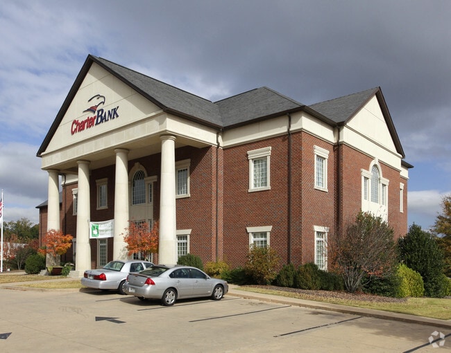
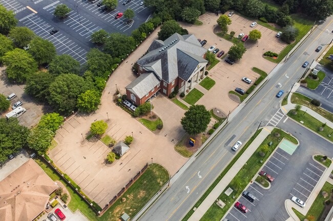
Property Record
820 Dixie St, Carrollton, GA 30117

Current Lease Availabilities
Property Detail
820 Dixie St
C06-0050001
BANK/2.34AC/ DIXIE ST C88
Financialbuilding
Carroll
C2
Georgia
B and X Area of moderate flood hazard, usually the area between the limits of the 100-year and 500-year floods.
2.34 AC
2025
W Carroll County
2025
Atlanta
911002
Atlanta-Sandy Springs-Roswell, GA
7,059 SF
NEARBY LISTINGS FOR SALE OR LEASE
DEMOGRAPHICS near 820 Dixie St
1 mile
3 mile
5 mile
2025 Total Population
4,344
30,929
48,275
2030 Population
4,692
33,221
51,894
Pop Growth 2025-2030
+ 8.01%
+ 7.41%
+ 7.50%
Average Age
38
36
36
2025 Total Households
1,750
11,269
17,336
HH Growth 2025-2030
+ 7.89%
+ 7.55%
+ 7.61%
Median Household Inc
$75,145
$56,677
$62,424
Avg Household Size
2.40
2.50
2.60
2025 Avg HH Vehicles
2.00
2.00
2.00
Median Home Value
$313,551
$306,801
$298,345
Median Year Built
1980
1985
1986
Nearby Places
Map Layers
Map Styles
 Street
 Aerial
Layers
 Traffic
 Biking
Places
Listings with unknown addresses are not visible on the map
- Restaurants
- Banks
- Shops
- Fitness
- Groceries
Nearby Properties
Address
Land Use
TOTAL SIZE
Lot Size
Zoning
Address
Land Use
TOTAL SIZE
Lot Size
Zoning
53.04 AC
OI
Address
Land Use
TOTAL SIZE
Lot Size
Zoning
50,000 SF
28.63 AC
HS
Address
Land Use
TOTAL SIZE
Lot Size
Zoning
106,769 SF
11.26 AC
HS
Address
Land Use
TOTAL SIZE
Lot Size
Zoning
1,542,912 SF
118.16 AC
M2
Address
Land Use
TOTAL SIZE
Lot Size
Zoning
261,905 SF
64.74 AC
R2
Address
Land Use
TOTAL SIZE
Lot Size
Zoning
152,962 SF
108.90 AC
OI
Address
Land Use
TOTAL SIZE
Lot Size
Zoning
351,903 SF
30.04 AC
C2
Address
Land Use
TOTAL SIZE
Lot Size
Zoning
39,268 SF
12.05 AC
RM-10
Address
Land Use
TOTAL SIZE
Lot Size
Zoning
134,113 SF
2.80 AC
OI
Address
Land Use
TOTAL SIZE
Lot Size
Zoning
32,778 SF
3.89 AC
OI
Address
Land Use
TOTAL SIZE
Lot Size
Zoning
35.33 AC
OI
Address
Land Use
TOTAL SIZE
Lot Size
Zoning
354,354 SF
51.15 AC
I
Address
Land Use
TOTAL SIZE
Lot Size
Zoning
159,860 SF
20.74 AC
C2
Address
Land Use
TOTAL SIZE
Lot Size
Zoning
73,900 SF
10.57 AC
C2
Address
Land Use
TOTAL SIZE
Lot Size
Zoning
142,740 SF
8.13 AC
C2
Address
Land Use
TOTAL SIZE
Lot Size
Zoning
44,708 SF
9.92 AC
RESIDENTIA
Address
Land Use
TOTAL SIZE
Lot Size
Zoning
217,766 SF
28.46 AC
C2
Address
Land Use
TOTAL SIZE
Lot Size
Zoning
13,585 SF
14.93 AC
R3
Address
Land Use
TOTAL SIZE
Lot Size
Zoning
56,458 SF
21.87 AC
R3
Address
Land Use
TOTAL SIZE
Lot Size
Zoning
23,801 SF
14.78 AC
PD/R-M
Address
Land Use
TOTAL SIZE
Lot Size
Zoning
13,185 SF
26.29 AC
R4
Address
Land Use
TOTAL SIZE
Lot Size
Zoning
83,421 SF
4.28 AC
C2
Address
Land Use
TOTAL SIZE
Lot Size
Zoning
19,960 SF
0.53 AC
HS
Address
Land Use
TOTAL SIZE
Lot Size
Zoning
97,509 SF
15.50 AC
001
Address
Land Use
TOTAL SIZE
Lot Size
Zoning
138,903 SF
15.27 AC
C2
Address
Land Use
TOTAL SIZE
Lot Size
Zoning
7,700 SF
7.08 AC
R3
Address
Land Use
TOTAL SIZE
Lot Size
Zoning
17,102 SF
33.57 AC
R3
Address
Land Use
TOTAL SIZE
Lot Size
Zoning
17,000 SF
13.52 AC
R3
Address
Land Use
TOTAL SIZE
Lot Size
Zoning
276,510 SF
6.78 AC
M1
Address
Land Use
TOTAL SIZE
Lot Size
Zoning
69,336 SF
25.63 AC
M1
The World's #1 Commercial Real Estate Marketplace
Connect with us
© 2026 CoStar Group
The information above has been obtained from sources believed reliable. While we do not doubt its accuracy we have not verified it and make no guarantee, warranty or representation about it. It is your responsibility to independently confirm its accuracy and completeness. Any projections, opinions, assumptions, or estimates used are for example only and do not represent the current or future performance of the property. The value of this transaction to you depends on tax and other factors which should be evaluated by your tax, financial, and legal advisors. You and your advisors should conduct a careful, independent investigation of the property to determine to your satisfaction the suitability of the property for your needs.