Property Record
8200 State Highway 191, Midland, TX 79707
Property Detail
8200 State Highway 191
Other Market Areas
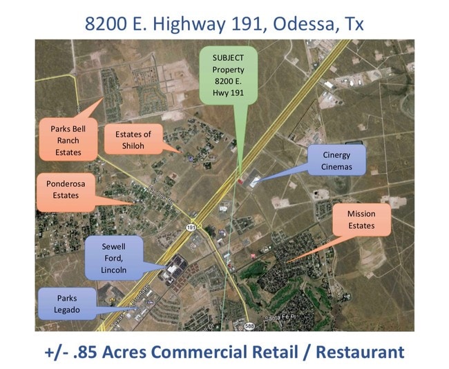
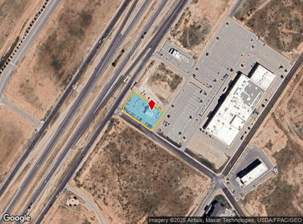
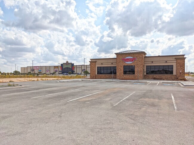
Dorado Center
Midland, TX
ACRES: 0.849 BLK: 003 LOT: 003 ADDN: DORADO CENTER 3RD FILING
R000214-351
Midland
Officebuilding
Texas
2025
3
2025
0.85 AC
010120
Midland & Odessa
4,400 SF
NEARBY LISTINGS FOR SALE OR LEASE
DEMOGRAPHICS near 8200 State Highway 191
1 mile
3 mile
5 mile
2024 Total Population
7,042
21,023
46,164
2029 Population
7,755
22,190
47,118
Pop Growth 2024-2029
+ 10.12%
+ 5.55%
+ 2.07%
Average Age
34
35
35
2024 Total Households
2,773
8,281
17,966
HH Growth 2024-2029
+ 9.88%
+ 5.36%
+ 1.87%
Median Household Inc
$74,952
$79,815
$72,581
Avg Household Size
2.50
2.50
2.50
2024 Avg HH Vehicles
2.00
2.00
2.00
Median Home Value
$376,822
$360,109
$293,441
Median Year Built
2011
2010
1995
Nearby Places
Map Layers
Map Styles
 Street
 Aerial
Transit
 Traffic
 Biking
Places
Listings with unknown addresses are not visible on the map
- Restaurants
- Banks
- Shops
- Fitness
- Groceries
PUBLIC TRANSPORTATION
AIRPORT
Midland International Air And Space Port
Drive
Walk
Distance
Midland International Air And Space Port
14 min
6.3 mi
SALE & LEASE HISTORY
LISTING DATE
SALE/LEASE

Sep 24, 2020
For Sale
Aug 12, 2019
For Sale
Nearby Properties
Address
Land Use
TOTAL SIZE
Lot Size
Zoning
Address
Land Use
TOTAL SIZE
Lot Size
Zoning
388,320 SF
17.47 AC
Address
Land Use
TOTAL SIZE
Lot Size
Zoning
230,976 SF
12.96 AC
Address
Land Use
TOTAL SIZE
Lot Size
Zoning
350,512 SF
15.01 AC
Address
Land Use
TOTAL SIZE
Lot Size
Zoning
531,600 SF
15.73 AC
EF8
Address
Land Use
TOTAL SIZE
Lot Size
Zoning
3,120 SF
15.08 AC
Address
Land Use
TOTAL SIZE
Lot Size
Zoning
225,556 SF
17.33 AC
EF9
Address
Land Use
TOTAL SIZE
Lot Size
Zoning
329,854 SF
16.69 AC
EF8
Address
Land Use
TOTAL SIZE
Lot Size
Zoning
2,580 SF
13.74 AC
Address
Land Use
TOTAL SIZE
Lot Size
Zoning
2,601 SF
11 AC
Address
Land Use
TOTAL SIZE
Lot Size
Zoning
319,056 SF
11.75 AC
EF3
Address
Land Use
TOTAL SIZE
Lot Size
Zoning
102,996 SF
22.37 AC
Address
Land Use
TOTAL SIZE
Lot Size
Zoning
336,677 SF
14.14 AC
EF8
Address
Land Use
TOTAL SIZE
Lot Size
Zoning
19,527 SF
14.75 AC
EF8
Address
Land Use
TOTAL SIZE
Lot Size
Zoning
103,571 SF
23.59 AC
EF3
Address
Land Use
TOTAL SIZE
Lot Size
Zoning
3,336 SF
11.21 AC
EF5
Address
Land Use
TOTAL SIZE
Lot Size
Zoning
36,084 SF
18.99 AC
EF3
Address
Land Use
TOTAL SIZE
Lot Size
Zoning
2,287 SF
8.15 AC
Address
Land Use
TOTAL SIZE
Lot Size
Zoning
156,000 SF
8.68 AC
EF5
Address
Land Use
TOTAL SIZE
Lot Size
Zoning
322,000 SF
11.58 AC
Address
Land Use
TOTAL SIZE
Lot Size
Zoning
69,192 SF
7.40 AC
EF8
Address
Land Use
TOTAL SIZE
Lot Size
Zoning
1,176 SF
9.55 AC
EF5
Address
Land Use
TOTAL SIZE
Lot Size
Zoning
48,634 SF
18.98 AC
EF9
Address
Land Use
TOTAL SIZE
Lot Size
Zoning
155,315 SF
18.88 AC
EF2
Address
Land Use
TOTAL SIZE
Lot Size
Zoning
80,884 SF
2.54 AC
EF5
Address
Land Use
TOTAL SIZE
Lot Size
Zoning
113,250 SF
10 AC
FD
Address
Land Use
TOTAL SIZE
Lot Size
Zoning
86,204 SF
2.33 AC
EF8
Address
Land Use
TOTAL SIZE
Lot Size
Zoning
4,800 SF
10.72 AC
Address
Land Use
TOTAL SIZE
Lot Size
Zoning
23,688 SF
2.50 AC
EF8
Address
Land Use
TOTAL SIZE
Lot Size
Zoning
26,000 SF
24.55 AC
Address
Land Use
TOTAL SIZE
Lot Size
Zoning
68,128 SF
6 AC
EF3
The World's #1 Commercial Real Estate Marketplace
Connect with us
© 2026 CoStar Group
The information above has been obtained from sources believed reliable. While we do not doubt its accuracy we have not verified it and make no guarantee, warranty or representation about it. It is your responsibility to independently confirm its accuracy and completeness. Any projections, opinions, assumptions, or estimates used are for example only and do not represent the current or future performance of the property. The value of this transaction to you depends on tax and other factors which should be evaluated by your tax, financial, and legal advisors. You and your advisors should conduct a careful, independent investigation of the property to determine to your satisfaction the suitability of the property for your needs.