Property Record
8271 Louie Pepper Dr, Clinton, MD 20735

NEARBY LISTINGS FOR SALE OR LEASE
Property Detail
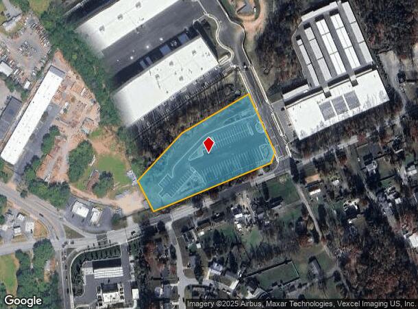
8271 Louie Pepper Dr
Washington-Arlington-Alexandria, DC-VA-MD-WV
Bellefonte
09-3744893
Prince George's
Industrialgeneral
Maryland
X
154
24033C0265E
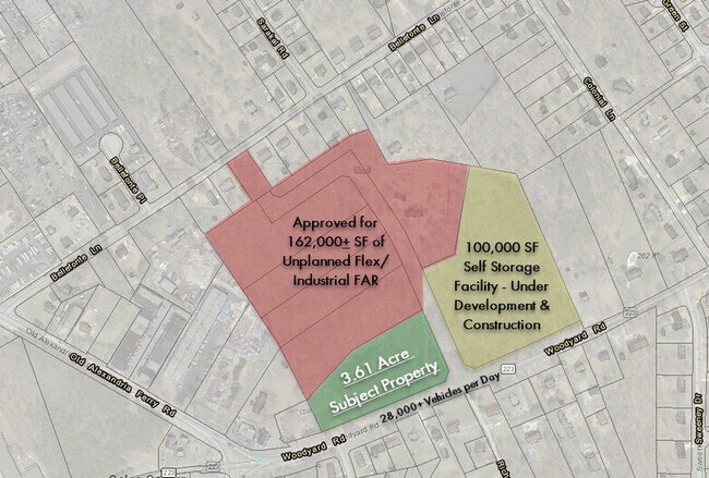
3.61 AC
2024
Branch Avenue Corridor
2025
Washington, DC
801214
DEMOGRAPHICS near 8271 Louie Pepper Dr
1 Mile
3 Mile
5 Mile
2024 Total Population
4,945
42,306
118,558
2029 Population
4,813
41,198
115,709
Pop Growth 2024-2029
(2.67%)
(2.62%)
(2.40%)
Average Age
44
43
42
2024 Total Households
1,747
14,402
42,918
HH Growth 2024-2029
(2.80%)
(2.76%)
(2.48%)
Median Household Inc
$120,815
$117,801
$110,482
Avg Household Size
2.70
2.80
2.70
2024 Avg HH Vehicles
2.00
2.00
2.00
Median Home Value
$424,499
$392,409
$385,140
Median Year Built
1991
1987
1984
Nearby Places
Map Layers
Map Styles
 Street
 Aerial
- Restaurants
- Banks
- Shops
- Fitness
- Groceries
PUBLIC TRANSPORTATION
AIRPORT
Ronald Reagan Washington Ntl
DRIVE
WALK
Distance
Ronald Reagan Washington Ntl
31 min
17.8 mi
Baltimore/Washington International Thurgood Marshall
DRIVE
WALK
Distance
Baltimore/Washington International Thurgood Marshall
57 min
39.0 mi
Washington Dulles International
DRIVE
WALK
Distance
Washington Dulles International
68 min
44.8 mi
Freight Ports
Port of Baltimore
DRIVE
WALK
Distance
Port of Baltimore
66 min
45.3 mi
SALE & LEASE HISTORY
LISTING DATE
SALE/LEASE

Sep 24, 2016
For Sale
Jan 20, 2020
For Sale
Nearby Properties
Address
Land Use
TOTAL SIZE
Lot Size
Zoning
Address
Land Use
TOTAL SIZE
Lot Size
Zoning
203.33 AC
IE
Address
Land Use
TOTAL SIZE
Lot Size
Zoning
353,064 SF
53.19 AC
CGO
Address
Land Use
TOTAL SIZE
Lot Size
Zoning
7,000 SF
354.62 AC
ROS
Address
Land Use
TOTAL SIZE
Lot Size
Zoning
111.87 AC
IE
Address
Land Use
TOTAL SIZE
Lot Size
Zoning
98.14 AC
IE
Address
Land Use
TOTAL SIZE
Lot Size
Zoning
341,372 SF
14.74 AC
RR
Address
Land Use
TOTAL SIZE
Lot Size
Zoning
73.26 AC
IE
Address
Land Use
TOTAL SIZE
Lot Size
Zoning
117.45 AC
IE
Address
Land Use
TOTAL SIZE
Lot Size
Zoning
223,219 SF
22 AC
CGO
Address
Land Use
TOTAL SIZE
Lot Size
Zoning
124.59 AC
IE
Address
Land Use
TOTAL SIZE
Lot Size
Zoning
74.38 AC
IE
Address
Land Use
TOTAL SIZE
Lot Size
Zoning
111.72 AC
IE
Address
Land Use
TOTAL SIZE
Lot Size
Zoning
269.41 AC
IE
Address
Land Use
TOTAL SIZE
Lot Size
Zoning
157.68 AC
IE
Address
Land Use
TOTAL SIZE
Lot Size
Zoning
138.27 AC
IE
Address
Land Use
TOTAL SIZE
Lot Size
Zoning
250.35 AC
IE
Address
Land Use
TOTAL SIZE
Lot Size
Zoning
207,504 SF
8.84 AC
I1
Address
Land Use
TOTAL SIZE
Lot Size
Zoning
116,550 SF
15.60 AC
IE
Address
Land Use
TOTAL SIZE
Lot Size
Zoning
102 AC
IE
Address
Land Use
TOTAL SIZE
Lot Size
Zoning
160,870 SF
3.75 AC
RMF48
Address
Land Use
TOTAL SIZE
Lot Size
Zoning
174,894 SF
7.54 AC
CGO
Address
Land Use
TOTAL SIZE
Lot Size
Zoning
55,724 SF
10.09 AC
IE
Address
Land Use
TOTAL SIZE
Lot Size
Zoning
67.32 AC
IE
Address
Land Use
TOTAL SIZE
Lot Size
Zoning
115,500 SF
3.10 AC
IE
Address
Land Use
TOTAL SIZE
Lot Size
Zoning
169.75 AC
IE
Address
Land Use
TOTAL SIZE
Lot Size
Zoning
83.26 AC
IE
Address
Land Use
TOTAL SIZE
Lot Size
Zoning
78,658 SF
9.13 AC
RR
Address
Land Use
TOTAL SIZE
Lot Size
Zoning
101,979 SF
2.11 AC
CGO
Address
Land Use
TOTAL SIZE
Lot Size
Zoning
161,410 SF
30 AC
RSF95
Address
Land Use
TOTAL SIZE
Lot Size
Zoning
200.65 AC
IE
The World's #1 Commercial Real Estate Marketplace
Connect with us
© 2025 CoStar Group
The information above has been obtained from sources believed reliable. While we do not doubt its accuracy we have not verified it and make no guarantee, warranty or representation about it. It is your responsibility to independently confirm its accuracy and completeness. Any projections, opinions, assumptions, or estimates used are for example only and do not represent the current or future performance of the property. The value of this transaction to you depends on tax and other factors which should be evaluated by your tax, financial, and legal advisors. You and your advisors should conduct a careful, independent investigation of the property to determine to your satisfaction the suitability of the property for your needs.