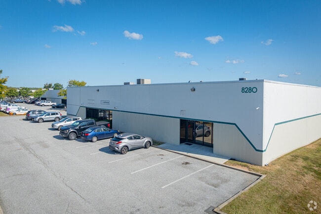
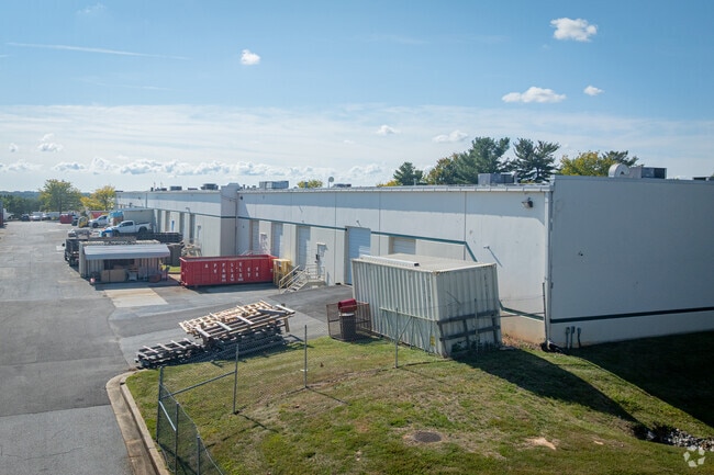
Property Record
8280 Patuxent Range Rd, Jessup, MD 20794

Property Detail
8280 Patuxent Range Rd
Baltimore-Columbia-Towson, MD
PAR F-1 4.280 A. 8280 PATUXENT RANGE RD BWIP ANNAPL JCT
06-600616
HOWARD
Commercialcondominium
Maryland
M2
f 1
B and X Area of moderate flood hazard, usually the area between the limits of the 100-year and 500-year floods.
4.29 AC
0
Route 1 Corridor
2025
Baltimore
606901
NEARBY LISTINGS FOR SALE OR LEASE
DEMOGRAPHICS near 8280 Patuxent Range Rd
1 mile
3 mile
5 mile
2025 Total Population
2,041
63,553
205,862
2030 Population
2,099
64,805
209,257
Pop Growth 2025-2030
+ 2.84%
+ 1.97%
+ 1.65%
Average Age
41
37
37
2025 Total Households
665
23,065
74,743
HH Growth 2025-2030
+ 2.86%
+ 1.81%
+ 1.60%
Median Household Inc
$69,374
$119,226
$118,644
Avg Household Size
2.70
2.60
2.70
2025 Avg HH Vehicles
2.00
2.00
2.00
Median Home Value
$241,935
$452,367
$456,086
Median Year Built
1995
1997
1990
Nearby Places
Map Layers
Map Styles
 Street
 Aerial
Layers
 Traffic
 Biking
Places
Listings with unknown addresses are not visible on the map
- Restaurants
- Banks
- Shops
- Fitness
- Groceries
PUBLIC TRANSPORTATION
COMMUTER RAIL
Jessup (Camden Line - Maryland Area Regional Commuter Trains (The MARC))
Drive
Walk
Distance
Jessup (Camden Line - Maryland Area Regional Commuter Trains (The MARC))
5 min
1.9 mi
Savage (Camden Line - Maryland Area Regional Commuter Trains (The MARC))
Drive
Walk
Distance
Savage (Camden Line - Maryland Area Regional Commuter Trains (The MARC))
5 min
2.5 mi
AIRPORT
Baltimore/Washington International Thurgood Marshall
Drive
Walk
Distance
Baltimore/Washington International Thurgood Marshall
19 min
10.6 mi
Ronald Reagan Washington Ntl
Drive
Walk
Distance
Ronald Reagan Washington Ntl
47 min
29.9 mi
Freight Ports
Port of Baltimore
Drive
Walk
Distance
Port of Baltimore
24 min
15.9 mi
SALE & LEASE HISTORY
LISTING DATE
SALE/LEASE

Mar 30, 2017
For Sale
Mar 13, 2017
For Sale
Jun 10, 2022
For Sale
Jun 10, 2022
For Sale
Jan 14, 2022
For Lease
Dec 22, 2021
For Sale
Dec 16, 2025
For Lease
Dec 09, 2025
For Sale
Aug 05, 2017
For Sale
Nearby Properties
Address
Land Use
TOTAL SIZE
Lot Size
Zoning
Address
Land Use
TOTAL SIZE
Lot Size
Zoning
1,007,900 SF
88.77 AC
M2
Address
Land Use
TOTAL SIZE
Lot Size
Zoning
594.68 AC
R1
Address
Land Use
TOTAL SIZE
Lot Size
Zoning
238,700 SF
7.43 AC
TOD
Address
Land Use
TOTAL SIZE
Lot Size
Zoning
732,668 SF
13.26 AC
MXDE
Address
Land Use
TOTAL SIZE
Lot Size
Zoning
853,520 SF
47.33 AC
M2
Address
Land Use
TOTAL SIZE
Lot Size
Zoning
31,730 SF
43.99 AC
RA15
Address
Land Use
TOTAL SIZE
Lot Size
Zoning
500,970 SF
18.88 AC
MXD-E
Address
Land Use
TOTAL SIZE
Lot Size
Zoning
796,368 SF
11.80 AC
R5
Address
Land Use
TOTAL SIZE
Lot Size
Zoning
376,918 SF
8.55 AC
W1
Address
Land Use
TOTAL SIZE
Lot Size
Zoning
560,407 SF
3.82 AC
Address
Land Use
TOTAL SIZE
Lot Size
Zoning
261,969 SF
12.13 AC
R5R10
Address
Land Use
TOTAL SIZE
Lot Size
Zoning
295,684 SF
33.25 AC
RSCMX
Address
Land Use
TOTAL SIZE
Lot Size
Zoning
77,028 SF
18.68 AC
NT
Address
Land Use
TOTAL SIZE
Lot Size
Zoning
307,626 SF
5.46 AC
CACLI
Address
Land Use
TOTAL SIZE
Lot Size
Zoning
234,264 SF
5.03 AC
W1
Address
Land Use
TOTAL SIZE
Lot Size
Zoning
221,100 SF
1.75 AC
MXD-E
Address
Land Use
TOTAL SIZE
Lot Size
Zoning
988,378 SF
115.55 AC
M1
Address
Land Use
TOTAL SIZE
Lot Size
Zoning
256,156 SF
14.56 AC
M1
Address
Land Use
TOTAL SIZE
Lot Size
Zoning
192,703 SF
6.67 AC
W-1
Address
Land Use
TOTAL SIZE
Lot Size
Zoning
490,875 SF
9.52 AC
MXD-E
Address
Land Use
TOTAL SIZE
Lot Size
Zoning
551,529 SF
9.52 AC
W1
Address
Land Use
TOTAL SIZE
Lot Size
Zoning
370,240 SF
4.18 AC
CACLI
Address
Land Use
TOTAL SIZE
Lot Size
Zoning
539,758 SF
48.32 AC
M1
Address
Land Use
TOTAL SIZE
Lot Size
Zoning
612,900 SF
37.43 AC
M2
Address
Land Use
TOTAL SIZE
Lot Size
Zoning
161,528 SF
10.86 AC
W1
Address
Land Use
TOTAL SIZE
Lot Size
Zoning
55,400 SF
10.19 AC
CACLI
Address
Land Use
TOTAL SIZE
Lot Size
Zoning
164,448 SF
3.87 AC
W1
Address
Land Use
TOTAL SIZE
Lot Size
Zoning
126,960 SF
13.72 AC
MXDR
Address
Land Use
TOTAL SIZE
Lot Size
Zoning
291,250 SF
30.09 AC
CECLI
Address
Land Use
TOTAL SIZE
Lot Size
Zoning
6,201 SF
71.87 AC
M 2
The World's #1 Commercial Real Estate Marketplace
Connect with us
© 2026 CoStar Group
The information above has been obtained from sources believed reliable. While we do not doubt its accuracy we have not verified it and make no guarantee, warranty or representation about it. It is your responsibility to independently confirm its accuracy and completeness. Any projections, opinions, assumptions, or estimates used are for example only and do not represent the current or future performance of the property. The value of this transaction to you depends on tax and other factors which should be evaluated by your tax, financial, and legal advisors. You and your advisors should conduct a careful, independent investigation of the property to determine to your satisfaction the suitability of the property for your needs.