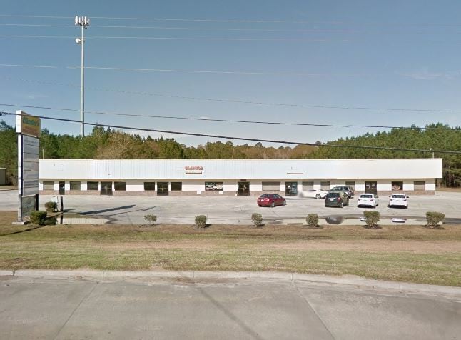
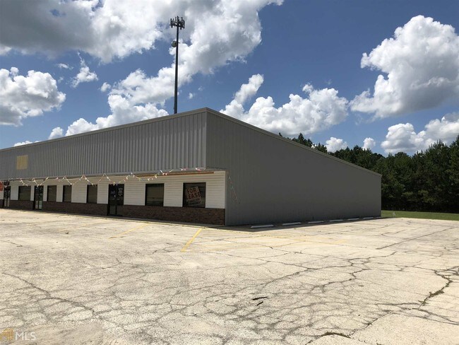
Property Record
8395 Us Highway 301, Claxton, GA 30417

Save to a Folder
{{folder.Name}}
{{folder.ListingIds.length}} Properties
{{folder.ListingIds.length}} Property
Create a New Folder
Property Detail
8395 Us Highway 301
024-008-007
PARCEL A-NATHAN KATZIF
Stripcommercialcenter
Evans
007
Georgia
B and X Area of moderate flood hazard, usually the area between the limits of the 100-year and 500-year floods.
5.11 AC
2025
Georgia South Area
2025
Other Market Areas
970300
Statesboro, GA
14,700 SF
NEARBY LISTINGS FOR SALE OR LEASE
DEMOGRAPHICS near 8395 Us Highway 301
1 mile
3 mile
5 mile
2025 Total Population
1,093
5,823
8,524
2030 Population
1,129
5,858
8,560
Pop Growth 2025-2030
+ 3.29%
+ 0.60%
+ 0.42%
Average Age
39
40
40
2025 Total Households
329
2,172
3,178
HH Growth 2025-2030
+ 2.74%
+ 0.41%
+ 0.38%
Median Household Inc
$52,636
$51,394
$53,759
Avg Household Size
2.30
2.40
2.40
2025 Avg HH Vehicles
1.00
2.00
2.00
Median Home Value
$328,082
$172,678
$159,612
Median Year Built
1983
1980
1984
Nearby Places
Map Layers
Map Styles
 Street
 Aerial
Layers
 Traffic
 Biking
Places
Listings with unknown addresses are not visible on the map
- Restaurants
- Banks
- Shops
- Fitness
- Groceries
SALE & LEASE HISTORY
LISTING DATE
SALE/LEASE

Sep 20, 2019
For Sale
Nearby Properties
Address
Land Use
TOTAL SIZE
Lot Size
Zoning
Address
Land Use
TOTAL SIZE
Lot Size
Zoning
119,515 SF
24.04 AC
007
Address
Land Use
TOTAL SIZE
Lot Size
Zoning
72,900 SF
10 AC
002
Address
Land Use
TOTAL SIZE
Lot Size
Zoning
75.88 AC
UNZONED RU
Address
Land Use
TOTAL SIZE
Lot Size
Zoning
59.18 AC
UNZONED RU
Address
Land Use
TOTAL SIZE
Lot Size
Zoning
89,432 SF
7.83 AC
002
Address
Land Use
TOTAL SIZE
Lot Size
Zoning
4.08 AC
COMMERCIAL
Address
Land Use
TOTAL SIZE
Lot Size
Zoning
23,383 SF
7.15 AC
002
Address
Land Use
TOTAL SIZE
Lot Size
Zoning
1,052 SF
4.11 AC
COMMERCIAL
Address
Land Use
TOTAL SIZE
Lot Size
Zoning
23,211 SF
2.16 AC
002
Address
Land Use
TOTAL SIZE
Lot Size
Zoning
34,250 SF
16.08 AC
007
Address
Land Use
TOTAL SIZE
Lot Size
Zoning
16,694 SF
3.60 AC
COMMERCIAL
Address
Land Use
TOTAL SIZE
Lot Size
Zoning
10,664 SF
1.87 AC
COMMERCIAL
Address
Land Use
TOTAL SIZE
Lot Size
Zoning
9,525 SF
1.25 AC
COMMERCIAL
Address
Land Use
TOTAL SIZE
Lot Size
Zoning
5.87 AC
UNZONED RU
Address
Land Use
TOTAL SIZE
Lot Size
Zoning
7.58 AC
UNZONED RU
Address
Land Use
TOTAL SIZE
Lot Size
Zoning
8,419 SF
1.45 AC
COMMERCIAL
Address
Land Use
TOTAL SIZE
Lot Size
Zoning
8,492 SF
1.29 AC
COMMERCIAL
Address
Land Use
TOTAL SIZE
Lot Size
Zoning
1,632 SF
227.14 AC
UNZONED RU
Address
Land Use
TOTAL SIZE
Lot Size
Zoning
6,222 SF
1.11 AC
002
Address
Land Use
TOTAL SIZE
Lot Size
Zoning
13,912 SF
1.03 AC
COMMERCIAL
Address
Land Use
TOTAL SIZE
Lot Size
Zoning
18,036 SF
2.09 AC
002
Address
Land Use
TOTAL SIZE
Lot Size
Zoning
7,400 SF
1.09 AC
002
Address
Land Use
TOTAL SIZE
Lot Size
Zoning
7,662 SF
0.31 AC
COMMERCIAL
Address
Land Use
TOTAL SIZE
Lot Size
Zoning
10,688 SF
1.03 AC
001
Address
Land Use
TOTAL SIZE
Lot Size
Zoning
12,200 SF
0.92 AC
002
Address
Land Use
TOTAL SIZE
Lot Size
Zoning
4.59 AC
COMMERCIAL
Address
Land Use
TOTAL SIZE
Lot Size
Zoning
1.12 AC
COMMERCIAL
Address
Land Use
TOTAL SIZE
Lot Size
Zoning
1.85 AC
COMMERCIAL
Address
Land Use
TOTAL SIZE
Lot Size
Zoning
12,576 SF
1.70 AC
007
The World's #1 Commercial Real Estate Marketplace
Connect with us
© 2026 CoStar Group
The information above has been obtained from sources believed reliable. While we do not doubt its accuracy we have not verified it and make no guarantee, warranty or representation about it. It is your responsibility to independently confirm its accuracy and completeness. Any projections, opinions, assumptions, or estimates used are for example only and do not represent the current or future performance of the property. The value of this transaction to you depends on tax and other factors which should be evaluated by your tax, financial, and legal advisors. You and your advisors should conduct a careful, independent investigation of the property to determine to your satisfaction the suitability of the property for your needs.