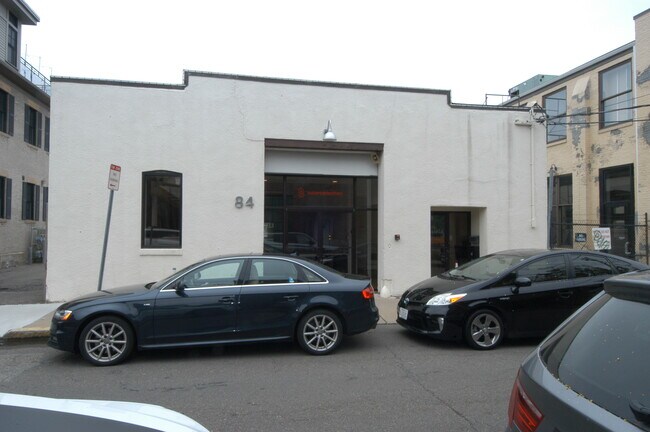
Property Record
84 Hamilton St, Cambridge, MA 02139

Save to a Folder
{{folder.Name}}
{{folder.ListingIds.length}} Properties
{{folder.ListingIds.length}} Property
Create a New Folder
Property Detail
84 Hamilton St
CAMB-000096-000000-000110
Middlesex
Officebuilding
Massachusetts
SD-10
110
B and X Area of moderate flood hazard, usually the area between the limits of the 100-year and 500-year floods.
0.13 AC
2025
Mid-Cambridge/Harvard Sq
2025
Boston
353200
Boston-Cambridge-Newton, MA-NH
3,800 SF
NEARBY LISTINGS FOR SALE OR LEASE
DEMOGRAPHICS near 84 Hamilton St
1 mile
3 mile
5 mile
2025 Total Population
69,644
565,259
1,046,411
2030 Population
72,105
584,112
1,075,946
Pop Growth 2025-2030
+ 3.53%
+ 3.34%
+ 2.82%
Average Age
32
36
37
2025 Total Households
24,651
244,271
432,274
HH Growth 2025-2030
+ 4.34%
+ 3.72%
+ 3.17%
Median Household Inc
$99,683
$107,759
$109,248
Avg Household Size
2.00
2.00
2.20
2025 Avg HH Vehicles
1.00
1.00
1.00
Median Home Value
$1,034,048
$987,453
$886,199
Median Year Built
1952
1951
1949
Nearby Places
Map Layers
Map Styles
 Street
 Aerial
Layers
 Traffic
 Biking
Places
Listings with unknown addresses are not visible on the map
- Restaurants
- Banks
- Shops
- Fitness
- Groceries
PUBLIC TRANSPORTATION
TRANSIT/SUBWAY
Central Square Station (Red Line - Massachusetts Bay Transportation Authority Subway (The T))
Drive
Walk
Distance
Central Square Station (Red Line - Massachusetts Bay Transportation Authority Subway (The T))
1 min
12 min
0.6 mi
Boston University West Station (Green Line - B - Massachusetts Bay Transportation Authority Subway (The T))
Drive
Walk
Distance
Boston University West Station (Green Line - B - Massachusetts Bay Transportation Authority Subway (The T))
3 min
15 min
0.8 mi
Boston University Central Station (Green Line - B - Massachusetts Bay Transportation Authority Subway (The T))
Drive
Walk
Distance
Boston University Central Station (Green Line - B - Massachusetts Bay Transportation Authority Subway (The T))
3 min
17 min
0.9 mi
Boston University East Station (Green Line - B - Massachusetts Bay Transportation Authority Subway (The T))
Drive
Walk
Distance
Boston University East Station (Green Line - B - Massachusetts Bay Transportation Authority Subway (The T))
3 min
19 min
1.0 mi
COMMUTER RAIL
Yawkey (Framingham/Worcester Line - Massachusetts Bay Transportation Authority Commuter Rail (Purple Line))
Drive
Walk
Distance
Yawkey (Framingham/Worcester Line - Massachusetts Bay Transportation Authority Commuter Rail (Purple Line))
5 min
2.9 mi
Boston Landing (Framingham/Worcester Line - MBTA)
Drive
Walk
Distance
Boston Landing (Framingham/Worcester Line - MBTA)
13 min
7.5 mi
AIRPORT
General Edward Lawrence Logan International
Drive
Walk
Distance
General Edward Lawrence Logan International
15 min
6.2 mi
Freight Ports
Port of Boston
Drive
Walk
Distance
Port of Boston
14 min
7.1 mi
SALE & LEASE HISTORY
LISTING DATE
SALE/LEASE

May 28, 2024
For Lease
May 03, 2024
For Sale
Apr 08, 2024
For Lease
Nearby Properties
Address
Land Use
TOTAL SIZE
Lot Size
Zoning
Address
Land Use
TOTAL SIZE
Lot Size
Zoning
909,764 SF
25.13 AC
E
Address
Land Use
TOTAL SIZE
Lot Size
Zoning
610,560 SF
4.01 AC
E
Address
Land Use
TOTAL SIZE
Lot Size
Zoning
439,500 SF
9.21 AC
E
Address
Land Use
TOTAL SIZE
Lot Size
Zoning
125,571 SF
3.25 AC
C-3
Address
Land Use
TOTAL SIZE
Lot Size
Zoning
150,192 SF
10.27 AC
E
Address
Land Use
TOTAL SIZE
Lot Size
Zoning
6.39 AC
C
Address
Land Use
TOTAL SIZE
Lot Size
Zoning
596,972 SF
7.32 AC
E
Address
Land Use
TOTAL SIZE
Lot Size
Zoning
530,200 SF
62.08 AC
E
Address
Land Use
TOTAL SIZE
Lot Size
Zoning
173,400 SF
1.14 AC
MXD
Address
Land Use
TOTAL SIZE
Lot Size
Zoning
142,458 SF
1.67 AC
C-3
Address
Land Use
TOTAL SIZE
Lot Size
Zoning
334,522 SF
1.26 AC
C
Address
Land Use
TOTAL SIZE
Lot Size
Zoning
312,269 SF
0.43 AC
C
Address
Land Use
TOTAL SIZE
Lot Size
Zoning
230,394 SF
0.60 AC
MXD
Address
Land Use
TOTAL SIZE
Lot Size
Zoning
46,259 SF
1.05 AC
E
Address
Land Use
TOTAL SIZE
Lot Size
Zoning
118,759 SF
0.92 AC
C
Address
Land Use
TOTAL SIZE
Lot Size
Zoning
304,349 SF
1.72 AC
Address
Land Use
TOTAL SIZE
Lot Size
Zoning
3.52 AC
C-3
Address
Land Use
TOTAL SIZE
Lot Size
Zoning
377,634 SF
4.86 AC
E
Address
Land Use
TOTAL SIZE
Lot Size
Zoning
1.13 AC
C
Address
Land Use
TOTAL SIZE
Lot Size
Zoning
239,377 SF
0.71 AC
MXD
Address
Land Use
TOTAL SIZE
Lot Size
Zoning
419,722 SF
2.03 AC
RC
Address
Land Use
TOTAL SIZE
Lot Size
Zoning
227,107 SF
7.70 AC
E
Address
Land Use
TOTAL SIZE
Lot Size
Zoning
2.81 AC
O-2
Address
Land Use
TOTAL SIZE
Lot Size
Zoning
448,796 SF
1.84 AC
C
Address
Land Use
TOTAL SIZE
Lot Size
Zoning
254,208 SF
3.83 AC
E
Address
Land Use
TOTAL SIZE
Lot Size
Zoning
4,355 SF
13.12 AC
E
Address
Land Use
TOTAL SIZE
Lot Size
Zoning
252,392 SF
0.52 AC
C
Address
Land Use
TOTAL SIZE
Lot Size
Zoning
237,935 SF
1.27 AC
C-3
Address
Land Use
TOTAL SIZE
Lot Size
Zoning
619,050 SF
0.45 AC
C
Address
Land Use
TOTAL SIZE
Lot Size
Zoning
6.14 AC
C
The World's #1 Commercial Real Estate Marketplace
Connect with us
© 2026 CoStar Group
The information above has been obtained from sources believed reliable. While we do not doubt its accuracy we have not verified it and make no guarantee, warranty or representation about it. It is your responsibility to independently confirm its accuracy and completeness. Any projections, opinions, assumptions, or estimates used are for example only and do not represent the current or future performance of the property. The value of this transaction to you depends on tax and other factors which should be evaluated by your tax, financial, and legal advisors. You and your advisors should conduct a careful, independent investigation of the property to determine to your satisfaction the suitability of the property for your needs.