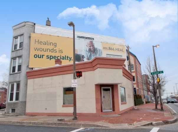
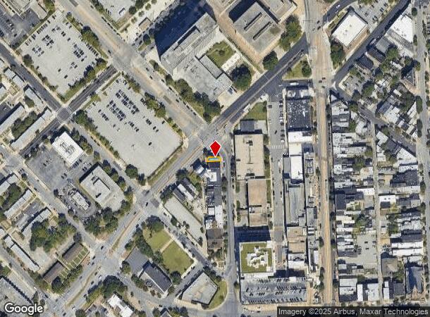
Property Record
846 N Eutaw St, Baltimore, MD 21201
Current Lease Availabilities
NEARBY LISTINGS FOR SALE OR LEASE
Property Detail
846 N Eutaw St
Baltimore-Columbia-Towson, MD
Baltimore City
0490-017
Maryland
Townhouserowhouse
0.02 AC
X
Baltimore Midtown
2400870018G
Baltimore
2,100 SF
DEMOGRAPHICS near 846 N Eutaw St
1 Mile
3 Mile
5 Mile
2024 Total Population
46,779
286,870
531,731
2029 Population
45,747
281,654
515,337
Pop Growth 2024-2029
(2.21%)
(1.82%)
(3.08%)
Average Age
37
38
39
2024 Total Households
25,681
131,161
228,604
HH Growth 2024-2029
(2.71%)
(2.28%)
(3.37%)
Median Household Inc
$49,191
$53,759
$54,598
Avg Household Size
1.70
2.10
2.20
2024 Avg HH Vehicles
1.00
1.00
1.00
Median Home Value
$260,381
$218,039
$195,615
Median Year Built
1954
1948
1949
Nearby Places
- Restaurants
- Banks
- Shops
- Fitness
- Groceries
PUBLIC TRANSPORTATION
TRANSIT/SUBWAY
State Center (Metro Subway - Maryland Transit Administration Metro Subway (Baltimore Metro))
DRIVE
WALK
Distance
State Center (Metro Subway - Maryland Transit Administration Metro Subway (Baltimore Metro))
0 min
3 min
0.1 mi
Cultural Center (Hunt Valley & BWI Marshall - Maryland Transit Administration Light Rail (Baltimore Light Rail), Penn Station & Camden Yards - Maryland Transit Administration Light Rail (Baltimore Light Rail), Timonium & Cromwell - Maryland Transit Administration Light Rail (Baltimore Light Rail))
DRIVE
WALK
Distance
Cultural Center (Hunt Valley & BWI Marshall - Maryland Transit Administration Light Rail (Baltimore Light Rail), Penn Station & Camden Yards - Maryland Transit Administration Light Rail (Baltimore Light Rail), Timonium & Cromwell - Maryland Transit Administration Light Rail (Baltimore Light Rail))
1 min
6 min
0.3 mi
Centre Street (Hunt Valley & BWI Marshall - Maryland Transit Administration Light Rail (Baltimore Light Rail), Penn Station & Camden Yards - Maryland Transit Administration Light Rail (Baltimore Light Rail), Timonium & Cromwell - Maryland Transit Administration Light Rail (Baltimore Light Rail))
DRIVE
WALK
Distance
Centre Street (Hunt Valley & BWI Marshall - Maryland Transit Administration Light Rail (Baltimore Light Rail), Penn Station & Camden Yards - Maryland Transit Administration Light Rail (Baltimore Light Rail), Timonium & Cromwell - Maryland Transit Administration Light Rail (Baltimore Light Rail))
1 min
7 min
0.3 mi
Lexington Market (Metro Subway - Maryland Transit Administration Metro Subway (Baltimore Metro))
DRIVE
WALK
Distance
Lexington Market (Metro Subway - Maryland Transit Administration Metro Subway (Baltimore Metro))
2 min
12 min
0.6 mi
University Of Baltimore/Mount Royal (Hunt Valley & BWI Marshall - Maryland Transit Administration Light Rail (Baltimore Light Rail), Penn Station & Camden Yards - Maryland Transit Administration Light Rail (Baltimore Light Rail), Timonium & Cromwell - Maryland Transit Administration Light Rail (Baltimore Light Rail))
DRIVE
WALK
Distance
University Of Baltimore/Mount Royal (Hunt Valley & BWI Marshall - Maryland Transit Administration Light Rail (Baltimore Light Rail), Penn Station & Camden Yards - Maryland Transit Administration Light Rail (Baltimore Light Rail), Timonium & Cromwell - Maryland Transit Administration Light Rail (Baltimore Light Rail))
2 min
12 min
0.6 mi
COMMUTER RAIL
Penn Station (Penn Line - Maryland Area Regional Commuter Trains (The MARC))
DRIVE
WALK
Distance
Penn Station (Penn Line - Maryland Area Regional Commuter Trains (The MARC))
4 min
14 min
0.7 mi
Camden Station (Camden Line - Maryland Area Regional Commuter Trains (The MARC))
DRIVE
WALK
Distance
Camden Station (Camden Line - Maryland Area Regional Commuter Trains (The MARC))
4 min
1.3 mi
AIRPORT
Baltimore/Washington International Thurgood Marshall
DRIVE
WALK
Distance
Baltimore/Washington International Thurgood Marshall
19 min
10.7 mi
Ronald Reagan Washington Ntl
DRIVE
WALK
Distance
Ronald Reagan Washington Ntl
65 min
43.1 mi
Freight Ports
Port of Baltimore
DRIVE
WALK
Distance
Port of Baltimore
5 min
1.5 mi
Nearby Properties
Address
Land Use
TOTAL SIZE
Lot Size
Zoning
Address
Land Use
TOTAL SIZE
Lot Size
Zoning
1,595,200 SF
20.36 AC
H
Address
Land Use
TOTAL SIZE
Lot Size
Zoning
1,871,691 SF
6.77 AC
C-5DC
Address
Land Use
TOTAL SIZE
Lot Size
Zoning
1,632,000 SF
106.32 AC
EC-2
Address
Land Use
TOTAL SIZE
Lot Size
Zoning
712,573 SF
1.32 AC
C-5DC
Address
Land Use
TOTAL SIZE
Lot Size
Zoning
20.26 AC
C-5DC
Address
Land Use
TOTAL SIZE
Lot Size
Zoning
308,887 SF
3.98 AC
C-5DC
Address
Land Use
TOTAL SIZE
Lot Size
Zoning
21.27 AC
C-5DC
Address
Land Use
TOTAL SIZE
Lot Size
Zoning
739,000 SF
2.79 AC
C-5DC
Address
Land Use
TOTAL SIZE
Lot Size
Zoning
3.89 AC
C-5DC
Address
Land Use
TOTAL SIZE
Lot Size
Zoning
830,720 SF
1.90 AC
I-MU
Address
Land Use
TOTAL SIZE
Lot Size
Zoning
400,000 SF
13.98 AC
0B051
Address
Land Use
TOTAL SIZE
Lot Size
Zoning
1,228,117 SF
9.43 AC
C-2
Address
Land Use
TOTAL SIZE
Lot Size
Zoning
256,816 SF
1.27 AC
EC-2
Address
Land Use
TOTAL SIZE
Lot Size
Zoning
654,224 SF
14.98 AC
C-5DC
Address
Land Use
TOTAL SIZE
Lot Size
Zoning
833,702 SF
1.74 AC
C-5DC
Address
Land Use
TOTAL SIZE
Lot Size
Zoning
911,487 SF
5.27 AC
C-5DC
Address
Land Use
TOTAL SIZE
Lot Size
Zoning
381,152 SF
3.46 AC
C-5DC
Address
Land Use
TOTAL SIZE
Lot Size
Zoning
2.61 AC
C-5DE
Address
Land Use
TOTAL SIZE
Lot Size
Zoning
236,614 SF
1.20 AC
BSC
Address
Land Use
TOTAL SIZE
Lot Size
Zoning
241,576 SF
6.13 AC
H
Address
Land Use
TOTAL SIZE
Lot Size
Zoning
199,435 SF
1.19 AC
BSC
Address
Land Use
TOTAL SIZE
Lot Size
Zoning
289,515 SF
1.10 AC
BSC
Address
Land Use
TOTAL SIZE
Lot Size
Zoning
10,386 SF
15.01 AC
C-5IH
Address
Land Use
TOTAL SIZE
Lot Size
Zoning
334,715 SF
1.77 AC
H
Address
Land Use
TOTAL SIZE
Lot Size
Zoning
656,306 SF
1.10 AC
C-5DC
Address
Land Use
TOTAL SIZE
Lot Size
Zoning
579,351 SF
0.96 AC
C-5DC
Address
Land Use
TOTAL SIZE
Lot Size
Zoning
189,700 SF
0.71 AC
TOD-4
Address
Land Use
TOTAL SIZE
Lot Size
Zoning
538,988 SF
8.40 AC
I-MU
Address
Land Use
TOTAL SIZE
Lot Size
Zoning
642,817 SF
1.91 AC
PC-2
Address
Land Use
TOTAL SIZE
Lot Size
Zoning
625,217 SF
2.12 AC
C-5DC
The World's #1 Commercial Real Estate Marketplace
Connect with us
© 2025 CoStar Group
The information above has been obtained from sources believed reliable. While we do not doubt its accuracy we have not verified it and make no guarantee, warranty or representation about it. It is your responsibility to independently confirm its accuracy and completeness. Any projections, opinions, assumptions, or estimates used are for example only and do not represent the current or future performance of the property. The value of this transaction to you depends on tax and other factors which should be evaluated by your tax, financial, and legal advisors. You and your advisors should conduct a careful, independent investigation of the property to determine to your satisfaction the suitability of the property for your needs.