Property Record
40 E 9Th St, Chicago, IL 60605

Current Lease Availabilities
NEARBY LISTINGS FOR SALE OR LEASE
Property Detail
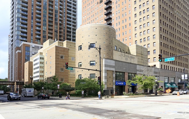
40 E 9Th St
Chicago
Burnham Park Plaza Condos
Chicago-Naperville-Elgin, IL-IN
Cook
17-15-304-052-1171
Illinois
Condominium
1.53 AC
X
South Loop
17031C0507J
DEMOGRAPHICS near 40 E 9Th St
1 Mile
3 Mile
5 Mile
2024 Total Population
58,693
370,684
753,542
2029 Population
58,511
364,733
730,264
Pop Growth 2024-2029
(0.31%)
(1.61%)
(3.09%)
Average Age
37
38
37
2024 Total Households
31,813
200,559
368,854
HH Growth 2024-2029
(0.39%)
(1.53%)
(2.87%)
Median Household Inc
$116,703
$104,207
$91,255
Avg Household Size
1.70
1.80
1.90
2024 Avg HH Vehicles
1.00
1.00
1.00
Median Home Value
$418,211
$463,446
$457,986
Median Year Built
2002
1989
1973
Nearby Places
Map Layers
Map Styles
 Street
 Aerial
- Restaurants
- Banks
- Shops
- Fitness
- Groceries
PUBLIC TRANSPORTATION
TRANSIT/SUBWAY
Harrison Station (Red Line - Chicago Transit Authority "L" Trains (The "L"))
DRIVE
WALK
Distance
Harrison Station (Red Line - Chicago Transit Authority "L" Trains (The "L"))
1 min
5 min
0.3 mi
Roosevelt Station (Green, Orange Lines) (Green Line - Chicago Transit Authority "L" Trains (The "L"), Orange Line - Chicago Transit Authority "L" Trains (The "L"))
DRIVE
WALK
Distance
Roosevelt Station (Green, Orange Lines) (Green Line - Chicago Transit Authority "L" Trains (The "L"), Orange Line - Chicago Transit Authority "L" Trains (The "L"))
1 min
5 min
0.3 mi
Roosevelt Station (Red Line) (Red Line - Chicago Transit Authority "L" Trains (The "L"))
DRIVE
WALK
Distance
Roosevelt Station (Red Line) (Red Line - Chicago Transit Authority "L" Trains (The "L"))
1 min
7 min
0.3 mi
Harold Washington Library-State/Van Buren (Brown Line - Chicago Transit Authority "L" Trains (The "L"), Orange Line - Chicago Transit Authority "L" Trains (The "L"), Pink Line - Chicago Transit Authority "L" Trains (The "L"), Purple Line - Chicago Transit Authority "L" Trains (The "L"))
DRIVE
WALK
Distance
Harold Washington Library-State/Van Buren (Brown Line - Chicago Transit Authority "L" Trains (The "L"), Orange Line - Chicago Transit Authority "L" Trains (The "L"), Pink Line - Chicago Transit Authority "L" Trains (The "L"), Purple Line - Chicago Transit Authority "L" Trains (The "L"))
1 min
10 min
0.5 mi
Lasalle Station (Blue Line) (Blue Line - Chicago Transit Authority "L" Trains (The "L"))
DRIVE
WALK
Distance
Lasalle Station (Blue Line) (Blue Line - Chicago Transit Authority "L" Trains (The "L"))
1 min
12 min
0.6 mi
COMMUTER RAIL
Museum Campus/11Th St Station (Metra Electric Line - Northeast Illinois Regional Commuter Railroad (Metra), South Shore Line - Northeast Illinois Regional Commuter Railroad (Metra))
DRIVE
WALK
Distance
Museum Campus/11Th St Station (Metra Electric Line - Northeast Illinois Regional Commuter Railroad (Metra), South Shore Line - Northeast Illinois Regional Commuter Railroad (Metra))
2 min
8 min
0.4 mi
Chicago Lasalle Station (Rock Island District Line - Northeast Illinois Regional Commuter Railroad (Metra))
DRIVE
WALK
Distance
Chicago Lasalle Station (Rock Island District Line - Northeast Illinois Regional Commuter Railroad (Metra))
2 min
12 min
0.7 mi
AIRPORT
Chicago Midway International
DRIVE
WALK
Distance
Chicago Midway International
17 min
10.3 mi
Chicago O'Hare International
DRIVE
WALK
Distance
Chicago O'Hare International
30 min
18.7 mi
Freight Ports
Port Milwaukee
DRIVE
WALK
Distance
Port Milwaukee
108 min
86.9 mi
Nearby Properties
Address
Land Use
TOTAL SIZE
Lot Size
Zoning
Address
Land Use
TOTAL SIZE
Lot Size
Zoning
4,667,723 SF
2.94 AC
DC-16
Address
Land Use
TOTAL SIZE
Lot Size
Zoning
3,457,865 SF
3.74 AC
PD 70
Address
Land Use
TOTAL SIZE
Lot Size
Zoning
1,546,909 SF
0.98 AC
PD 1369
Address
Land Use
TOTAL SIZE
Lot Size
Zoning
1,496,448 SF
2 AC
PD 376
Address
Land Use
TOTAL SIZE
Lot Size
Zoning
1,396,750 SF
4.09 AC
PD 98
Address
Land Use
TOTAL SIZE
Lot Size
Zoning
1,362,475 SF
1.97 AC
PD 1226
Address
Land Use
TOTAL SIZE
Lot Size
Zoning
2,343,906 SF
2.32 AC
PD 70
Address
Land Use
TOTAL SIZE
Lot Size
Zoning
4,296,046 SF
6.15 AC
DC-16
Address
Land Use
TOTAL SIZE
Lot Size
Zoning
3,914,400 SF
5.70 AC
DC-16
Address
Land Use
TOTAL SIZE
Lot Size
Zoning
1,810,145 SF
1.03 AC
PD 365
Address
Land Use
TOTAL SIZE
Lot Size
Zoning
3,090,691 SF
3.30 AC
PD 377,PD
Address
Land Use
TOTAL SIZE
Lot Size
Zoning
1,215,367 SF
3.76 AC
PD 675
Address
Land Use
TOTAL SIZE
Lot Size
Zoning
0.82 AC
PD 1115
Address
Land Use
TOTAL SIZE
Lot Size
Zoning
0.88 AC
DC-16,PD 9
Address
Land Use
TOTAL SIZE
Lot Size
Zoning
2,750,656 SF
6.29 AC
PD 1065
Address
Land Use
TOTAL SIZE
Lot Size
Zoning
831,084 SF
2.05 AC
PD 316
Address
Land Use
TOTAL SIZE
Lot Size
Zoning
1,888,207 SF
2.03 AC
PD 264
Address
Land Use
TOTAL SIZE
Lot Size
Zoning
1,600,546 SF
1.04 AC
PD 191
Address
Land Use
TOTAL SIZE
Lot Size
Zoning
1,231,710 SF
2.01 AC
PD 27
Address
Land Use
TOTAL SIZE
Lot Size
Zoning
590,844 SF
0.80 AC
PD 26
Address
Land Use
TOTAL SIZE
Lot Size
Zoning
2,429,909 SF
2.93 AC
PD 882
Address
Land Use
TOTAL SIZE
Lot Size
Zoning
2,456,900 SF
0.96 AC
PD 256
Address
Land Use
TOTAL SIZE
Lot Size
Zoning
2,612,517 SF
1.28 AC
PD 256
Address
Land Use
TOTAL SIZE
Lot Size
Zoning
2.06 AC
DX-16
Address
Land Use
TOTAL SIZE
Lot Size
Zoning
1,272,928 SF
2.33 AC
PD 368
Address
Land Use
TOTAL SIZE
Lot Size
Zoning
1.23 AC
PD 291
Address
Land Use
TOTAL SIZE
Lot Size
Zoning
1,502,279 SF
3.79 AC
PD 98
Address
Land Use
TOTAL SIZE
Lot Size
Zoning
1.54 AC
PD 743
Address
Land Use
TOTAL SIZE
Lot Size
Zoning
1,559,966 SF
1.38 AC
DC-12
Address
Land Use
TOTAL SIZE
Lot Size
Zoning
1,493,502 SF
1.31 AC
PD 70
The World's #1 Commercial Real Estate Marketplace
Connect with us
© 2026 CoStar Group
The information above has been obtained from sources believed reliable. While we do not doubt its accuracy we have not verified it and make no guarantee, warranty or representation about it. It is your responsibility to independently confirm its accuracy and completeness. Any projections, opinions, assumptions, or estimates used are for example only and do not represent the current or future performance of the property. The value of this transaction to you depends on tax and other factors which should be evaluated by your tax, financial, and legal advisors. You and your advisors should conduct a careful, independent investigation of the property to determine to your satisfaction the suitability of the property for your needs.