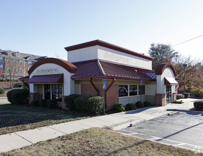
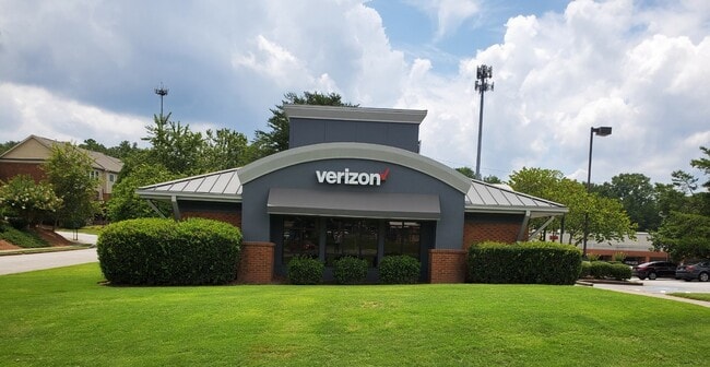
Property Record
8514 Holcomb Bridge Rd, Alpharetta, GA 30022
NEARBY LISTINGS FOR SALE OR LEASE
Property Detail
8514 Holcomb Bridge Rd
12-3080-0878-025-8
Fulton
Storebuilding
Georgia
X
878
13089C0010K
0.80 AC
2024
Roswell/Alpharetta
2025
Atlanta
011439
Atlanta-Sandy Springs-Roswell, GA
2,775 SF
DEMOGRAPHICS near 8514 Holcomb Bridge Rd
1 Mile
3 Mile
5 Mile
2024 Total Population
7,619
71,156
206,040
2029 Population
7,757
72,700
209,631
Pop Growth 2024-2029
+ 1.81%
+ 2.17%
+ 1.74%
Average Age
41
41
39
2024 Total Households
3,264
27,949
80,698
HH Growth 2024-2029
+ 1.87%
+ 2.28%
+ 1.79%
Median Household Inc
$97,599
$105,490
$95,983
Avg Household Size
2.30
2.50
2.50
2024 Avg HH Vehicles
2.00
2.00
2.00
Median Home Value
$513,210
$489,686
$477,402
Median Year Built
1986
1986
1987
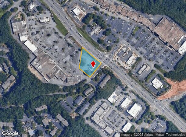
Nearby Places
Map Layers
Map Styles
 Street
 Aerial
- Restaurants
- Banks
- Shops
- Fitness
- Groceries
PUBLIC TRANSPORTATION
AIRPORT
Hartsfield - Jackson Atlanta International
DRIVE
WALK
Distance
Hartsfield - Jackson Atlanta International
47 min
33.3 mi
Freight Ports
Georgia Ports - Savannah
DRIVE
WALK
Distance
Georgia Ports - Savannah
303 min
267.7 mi
SALE & LEASE HISTORY
LISTING DATE
SALE/LEASE

Oct 27, 2020
For Lease
Jan 14, 2021
For Lease
Nearby Properties
Address
Land Use
TOTAL SIZE
Lot Size
Zoning
Address
Land Use
TOTAL SIZE
Lot Size
Zoning
599,105 SF
9.13 AC
M1
Address
Land Use
TOTAL SIZE
Lot Size
Zoning
9,544,248 SF
74.91 AC
R4
Address
Land Use
TOTAL SIZE
Lot Size
Zoning
545,074 SF
53.40 AC
RM8
Address
Land Use
TOTAL SIZE
Lot Size
Zoning
1,196,908 SF
30.28 AC
OI
Address
Land Use
TOTAL SIZE
Lot Size
Zoning
1,423,656 SF
15.44 AC
OI
Address
Land Use
TOTAL SIZE
Lot Size
Zoning
4,821,900 SF
20.58 AC
R4C
Address
Land Use
TOTAL SIZE
Lot Size
Zoning
459,745 SF
50.72 AC
RM10
Address
Land Use
TOTAL SIZE
Lot Size
Zoning
6,769,095 SF
21.82 AC
OI
Address
Land Use
TOTAL SIZE
Lot Size
Zoning
211,069 SF
14.91 AC
OI
Address
Land Use
TOTAL SIZE
Lot Size
Zoning
390,776 SF
43.96 AC
RM8
Address
Land Use
TOTAL SIZE
Lot Size
Zoning
205,850 SF
24.63 AC
RM10
Address
Land Use
TOTAL SIZE
Lot Size
Zoning
204,333 SF
39.43 AC
RM10
Address
Land Use
TOTAL SIZE
Lot Size
Zoning
1,592,455 SF
21.50 AC
R3
Address
Land Use
TOTAL SIZE
Lot Size
Zoning
336,694 SF
32.05 AC
RM10
Address
Land Use
TOTAL SIZE
Lot Size
Zoning
228,548 SF
16.50 AC
RM10
Address
Land Use
TOTAL SIZE
Lot Size
Zoning
1,676,766 SF
23 AC
OIC
Address
Land Use
TOTAL SIZE
Lot Size
Zoning
2,849,264 SF
21 AC
OI
Address
Land Use
TOTAL SIZE
Lot Size
Zoning
270,326 SF
31.96 AC
RM8
Address
Land Use
TOTAL SIZE
Lot Size
Zoning
195,885 SF
11.73 AC
RM13
Address
Land Use
TOTAL SIZE
Lot Size
Zoning
161,306 SF
13.42 AC
R100
Address
Land Use
TOTAL SIZE
Lot Size
Zoning
1,438,388 SF
27.46 AC
OI
Address
Land Use
TOTAL SIZE
Lot Size
Zoning
2,066,346 SF
22.96 AC
R4C
Address
Land Use
TOTAL SIZE
Lot Size
Zoning
192,401 SF
19 AC
RM10
Address
Land Use
TOTAL SIZE
Lot Size
Zoning
197,180 SF
21.48 AC
RM13
Address
Land Use
TOTAL SIZE
Lot Size
Zoning
285,310 SF
30.56 AC
RM10
Address
Land Use
TOTAL SIZE
Lot Size
Zoning
515,328 SF
3.71 AC
M1
Address
Land Use
TOTAL SIZE
Lot Size
Zoning
1,994,949 SF
14.41 AC
R4C
Address
Land Use
TOTAL SIZE
Lot Size
Zoning
51.89 AC
OI
Address
Land Use
TOTAL SIZE
Lot Size
Zoning
51,930 SF
61.63 AC
R1
Address
Land Use
TOTAL SIZE
Lot Size
Zoning
5,720 SF
222.73 AC
RA200
The World's #1 Commercial Real Estate Marketplace
Connect with us
© 2025 CoStar Group
The information above has been obtained from sources believed reliable. While we do not doubt its accuracy we have not verified it and make no guarantee, warranty or representation about it. It is your responsibility to independently confirm its accuracy and completeness. Any projections, opinions, assumptions, or estimates used are for example only and do not represent the current or future performance of the property. The value of this transaction to you depends on tax and other factors which should be evaluated by your tax, financial, and legal advisors. You and your advisors should conduct a careful, independent investigation of the property to determine to your satisfaction the suitability of the property for your needs.