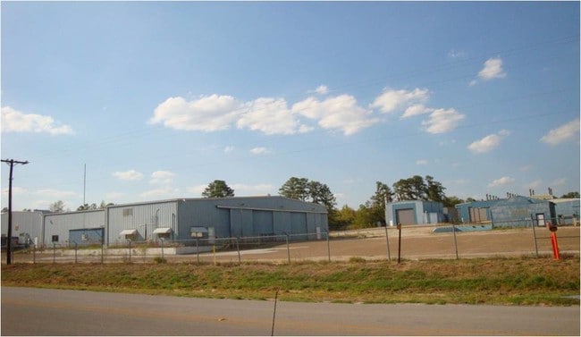
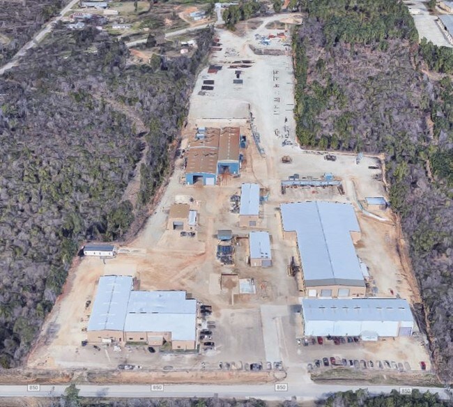
Property Record
8521 Fm 850, Tyler, TX 75705

Property Detail
8521 Fm 850
1-00000-0191-01-049010
ABST A0191 P CHERINOTRACT 49A,52.2 (PT 19.683 AC NET/SEE TR 80A&80A.2)
Assemblylightindustrial
Smith
B and X Area of moderate flood hazard, usually the area between the limits of the 100-year and 500-year floods.
Texas
2025
11.19 AC
2025
Tyler
001806
Other Market Areas
24,495 SF
Tyler, TX
NEARBY LISTINGS FOR SALE OR LEASE
DEMOGRAPHICS near 8521 Fm 850
1 mile
3 mile
5 mile
2025 Total Population
1,486
28,904
87,126
2030 Population
1,577
30,598
91,955
Pop Growth 2025-2030
+ 6.12%
+ 5.86%
+ 5.54%
Average Age
35
35
37
2025 Total Households
548
9,865
32,148
HH Growth 2025-2030
+ 5.66%
+ 5.68%
+ 5.12%
Median Household Inc
$54,909
$58,985
$60,162
Avg Household Size
2.70
2.60
2.50
2025 Avg HH Vehicles
2.00
2.00
2.00
Median Home Value
$81,446
$174,620
$193,847
Median Year Built
1994
1973
1972
Nearby Places
Map Layers
Map Styles
 Street
 Aerial
Layers
 Traffic
 Biking
Places
Listings with unknown addresses are not visible on the map
- Restaurants
- Banks
- Shops
- Fitness
- Groceries
PUBLIC TRANSPORTATION
AIRPORT
Tyler Pounds Regional
Drive
Walk
Distance
Tyler Pounds Regional
21 min
11.6 mi
Freight Ports
Port of Shreveport
Drive
Walk
Distance
Port of Shreveport
121 min
102.2 mi
SALE & LEASE HISTORY
LISTING DATE
SALE/LEASE

Sep 22, 2017
For Sale
May 14, 2019
For Lease
Apr 25, 2019
For Sale
Nearby Properties
Address
Land Use
TOTAL SIZE
Lot Size
Zoning
Address
Land Use
TOTAL SIZE
Lot Size
Zoning
14,000 SF
144.13 AC
M2
Address
Land Use
TOTAL SIZE
Lot Size
Zoning
12.64 AC
Address
Land Use
TOTAL SIZE
Lot Size
Zoning
503,620 SF
11.42 AC
Address
Land Use
TOTAL SIZE
Lot Size
Zoning
1.47 AC
RMF
Address
Land Use
TOTAL SIZE
Lot Size
Zoning
9.98 AC
Address
Land Use
TOTAL SIZE
Lot Size
Zoning
Address
Land Use
TOTAL SIZE
Lot Size
Zoning
Address
Land Use
TOTAL SIZE
Lot Size
Zoning
37.07 AC
Address
Land Use
TOTAL SIZE
Lot Size
Zoning
16.53 AC
Address
Land Use
TOTAL SIZE
Lot Size
Zoning
1.78 AC
DBAC
Address
Land Use
TOTAL SIZE
Lot Size
Zoning
Address
Land Use
TOTAL SIZE
Lot Size
Zoning
448,500 SF
2.90 AC
INT
Address
Land Use
TOTAL SIZE
Lot Size
Zoning
238,658 SF
1.97 AC
INT
Address
Land Use
TOTAL SIZE
Lot Size
Zoning
25 AC
INT
Address
Land Use
TOTAL SIZE
Lot Size
Zoning
213,323 SF
1.21 AC
Address
Land Use
TOTAL SIZE
Lot Size
Zoning
2.40 AC
Address
Land Use
TOTAL SIZE
Lot Size
Zoning
Address
Land Use
TOTAL SIZE
Lot Size
Zoning
12,810 SF
12.07 AC
R1A
Address
Land Use
TOTAL SIZE
Lot Size
Zoning
20,071 SF
7.43 AC
Address
Land Use
TOTAL SIZE
Lot Size
Zoning
8,279 SF
14.06 AC
RMF
Address
Land Use
TOTAL SIZE
Lot Size
Zoning
111,030 SF
1.02 AC
Address
Land Use
TOTAL SIZE
Lot Size
Zoning
2,676 SF
8.28 AC
RMF
Address
Land Use
TOTAL SIZE
Lot Size
Zoning
Address
Land Use
TOTAL SIZE
Lot Size
Zoning
83,450 SF
Address
Land Use
TOTAL SIZE
Lot Size
Zoning
1.54 AC
Address
Land Use
TOTAL SIZE
Lot Size
Zoning
2,499 SF
7.77 AC
RMF
Address
Land Use
TOTAL SIZE
Lot Size
Zoning
7,343 SF
3.12 AC
Address
Land Use
TOTAL SIZE
Lot Size
Zoning
27,520 SF
5.91 AC
RMF
Address
Land Use
TOTAL SIZE
Lot Size
Zoning
47,996 SF
3.66 AC
Address
Land Use
TOTAL SIZE
Lot Size
Zoning
4,781 SF
6.32 AC
RMF
The World's #1 Commercial Real Estate Marketplace
Connect with us
© 2026 CoStar Group
The information above has been obtained from sources believed reliable. While we do not doubt its accuracy we have not verified it and make no guarantee, warranty or representation about it. It is your responsibility to independently confirm its accuracy and completeness. Any projections, opinions, assumptions, or estimates used are for example only and do not represent the current or future performance of the property. The value of this transaction to you depends on tax and other factors which should be evaluated by your tax, financial, and legal advisors. You and your advisors should conduct a careful, independent investigation of the property to determine to your satisfaction the suitability of the property for your needs.