Property Record
854 N Easton Rd, Doylestown, PA 18902
NEARBY LISTINGS FOR SALE OR LEASE
Property Detail
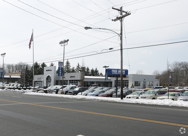
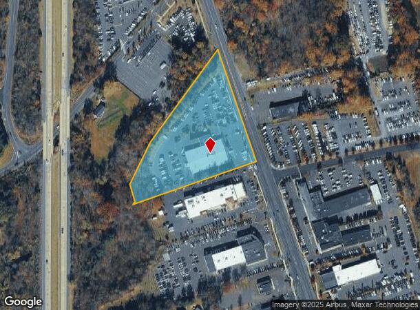
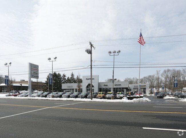
854 N Easton Rd
34-011-117-004
Site Dev Fred Beans Do
Vehiclerentalsvehiclesales
4.289AC WS N EASTON RD 33 8 S OF T401 529 ON N EASTON RD
A
Bucks
42017C0284K
Pennsylvania
2024
4.29 AC
2025
Upper Bucks County
104203
Philadelphia
12,625 SF
Philadelphia-Camden-Wilmington, PA-NJ-DE-MD
DEMOGRAPHICS near 854 N Easton Rd
1 Mile
3 Mile
5 Mile
2024 Total Population
5,247
35,293
71,515
2029 Population
5,172
35,295
71,358
Pop Growth 2024-2029
(1.43%)
+ 0.01%
(0.22%)
Average Age
40
44
43
2024 Total Households
2,017
14,086
26,345
HH Growth 2024-2029
(1.49%)
+ 0.28%
(0.06%)
Median Household Inc
$117,646
$120,188
$129,633
Avg Household Size
2.60
2.40
2.60
2024 Avg HH Vehicles
2.00
2.00
2.00
Median Home Value
$484,656
$560,172
$535,059
Median Year Built
1993
1982
1983
Nearby Places
Map Layers
Map Styles
 Street
 Aerial
- Restaurants
- Banks
- Shops
- Fitness
- Groceries
PUBLIC TRANSPORTATION
COMMUTER RAIL
Doylestown (R5 - Southeastern Pennsylvania Transportation Authority Regional Rail (SEPTA Regional Rail))
DRIVE
WALK
Distance
Doylestown (R5 - Southeastern Pennsylvania Transportation Authority Regional Rail (SEPTA Regional Rail))
7 min
2.4 mi
Delaware Valley College (R5 - Southeastern Pennsylvania Transportation Authority Regional Rail (SEPTA Regional Rail))
DRIVE
WALK
Distance
Delaware Valley College (R5 - Southeastern Pennsylvania Transportation Authority Regional Rail (SEPTA Regional Rail))
9 min
4.4 mi
AIRPORT
Trenton Mercer
DRIVE
WALK
Distance
Trenton Mercer
40 min
22.6 mi
Lehigh Valley International
DRIVE
WALK
Distance
Lehigh Valley International
58 min
32.3 mi
Philadelphia International
DRIVE
WALK
Distance
Philadelphia International
75 min
49.7 mi
Freight Ports
Port of Philadelphia
DRIVE
WALK
Distance
Port of Philadelphia
55 min
30.9 mi
Nearby Properties
Address
Land Use
TOTAL SIZE
Lot Size
Zoning
Address
Land Use
TOTAL SIZE
Lot Size
Zoning
72,937 SF
42.19 AC
CR
Address
Land Use
TOTAL SIZE
Lot Size
Zoning
254,699 SF
22.06 AC
RC
Address
Land Use
TOTAL SIZE
Lot Size
Zoning
192,365 SF
30.81 AC
C2
Address
Land Use
TOTAL SIZE
Lot Size
Zoning
8,120 SF
56.80 AC
C3
Address
Land Use
TOTAL SIZE
Lot Size
Zoning
30,939 SF
28.69 AC
I
Address
Land Use
TOTAL SIZE
Lot Size
Zoning
90,000 SF
7.25 AC
R2
Address
Land Use
TOTAL SIZE
Lot Size
Zoning
91,222 SF
13.75 AC
R2
Address
Land Use
TOTAL SIZE
Lot Size
Zoning
109,660 SF
9.81 AC
R3
Address
Land Use
TOTAL SIZE
Lot Size
Zoning
97,496 SF
12.67 AC
R3
Address
Land Use
TOTAL SIZE
Lot Size
Zoning
60,500 SF
5.90 AC
C2
Address
Land Use
TOTAL SIZE
Lot Size
Zoning
230,150 SF
12.10 AC
CR-H
Address
Land Use
TOTAL SIZE
Lot Size
Zoning
77,964 SF
9.79 AC
R3
Address
Land Use
TOTAL SIZE
Lot Size
Zoning
54,090 SF
7.25 AC
R4
Address
Land Use
TOTAL SIZE
Lot Size
Zoning
32,319 SF
7.30 AC
C1
Address
Land Use
TOTAL SIZE
Lot Size
Zoning
5,588 SF
0.82 AC
FC
Address
Land Use
TOTAL SIZE
Lot Size
Zoning
50,049 SF
5.45 AC
PC1
Address
Land Use
TOTAL SIZE
Lot Size
Zoning
16,828 SF
3.28 AC
R2
Address
Land Use
TOTAL SIZE
Lot Size
Zoning
515 SF
128.48 AC
R1
Address
Land Use
TOTAL SIZE
Lot Size
Zoning
51,286 SF
12.56 AC
R1
Address
Land Use
TOTAL SIZE
Lot Size
Zoning
42,587 SF
12.09 AC
R1
Address
Land Use
TOTAL SIZE
Lot Size
Zoning
21,285 SF
118.88 AC
R1
Address
Land Use
TOTAL SIZE
Lot Size
Zoning
32,298 SF
3.97 AC
R3
Address
Land Use
TOTAL SIZE
Lot Size
Zoning
25,479 SF
15.35 AC
I
Address
Land Use
TOTAL SIZE
Lot Size
Zoning
234,274 SF
24.12 AC
C4
Address
Land Use
TOTAL SIZE
Lot Size
Zoning
36,635 SF
2.97 AC
CR-H
Address
Land Use
TOTAL SIZE
Lot Size
Zoning
85,416 SF
4.30 AC
PC1
Address
Land Use
TOTAL SIZE
Lot Size
Zoning
34,068 SF
1.09 AC
R2
Address
Land Use
TOTAL SIZE
Lot Size
Zoning
15,336 SF
9.10 AC
R3
Address
Land Use
TOTAL SIZE
Lot Size
Zoning
38,530 SF
2.38 AC
RC1
Address
Land Use
TOTAL SIZE
Lot Size
Zoning
190,326 SF
8.95 AC
C1
The World's #1 Commercial Real Estate Marketplace
Connect with us
© 2025 CoStar Group
The information above has been obtained from sources believed reliable. While we do not doubt its accuracy we have not verified it and make no guarantee, warranty or representation about it. It is your responsibility to independently confirm its accuracy and completeness. Any projections, opinions, assumptions, or estimates used are for example only and do not represent the current or future performance of the property. The value of this transaction to you depends on tax and other factors which should be evaluated by your tax, financial, and legal advisors. You and your advisors should conduct a careful, independent investigation of the property to determine to your satisfaction the suitability of the property for your needs.