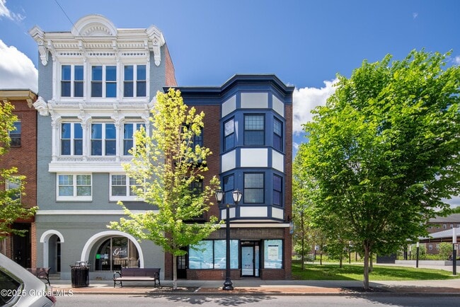
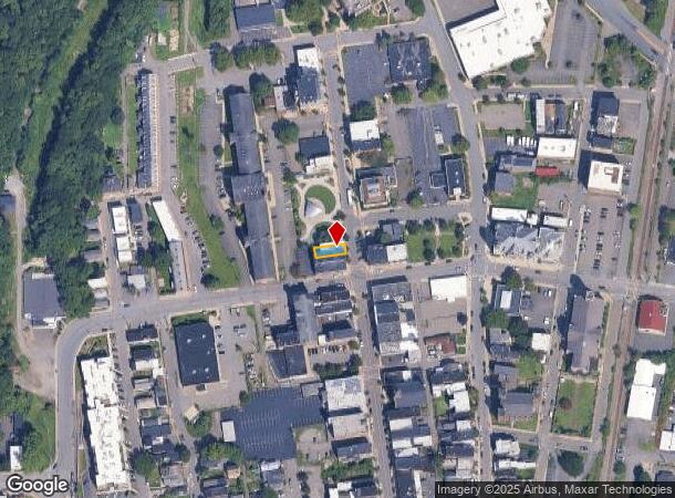
Property Record
86 Remsen St, Cohoes, NY 12047

NEARBY LISTINGS FOR SALE OR LEASE
Property Detail
86 Remsen St
010300-010-059-0001-021-000-0000
Map Of Certain Lands Of Harmony Mills Of
Commercialofficeresidentialmixeduse
Albany
X
New York
36001C0089D
21.000
2025
0.05 AC
2024
E Outer Albany County
012900
Albany/Schenectady/Troy
4,532 SF
Albany-Schenectady-Troy, NY
DEMOGRAPHICS near 86 Remsen St
1 Mile
3 Mile
5 Mile
2024 Total Population
13,239
67,201
138,828
2029 Population
12,842
66,259
137,585
Pop Growth 2024-2029
(3.00%)
(1.40%)
(0.90%)
Average Age
40
40
40
2024 Total Households
6,463
29,758
58,777
HH Growth 2024-2029
(3.23%)
(1.55%)
(0.99%)
Median Household Inc
$57,684
$58,921
$66,367
Avg Household Size
2.00
2.20
2.20
2024 Avg HH Vehicles
1.00
1.00
1.00
Median Home Value
$174,640
$212,108
$231,807
Median Year Built
1948
1955
1961
Nearby Places
- Restaurants
- Banks
- Shops
- Fitness
- Groceries
PUBLIC TRANSPORTATION
AIRPORT
Albany International
DRIVE
WALK
Distance
Albany International
13 min
6.4 mi
Freight Ports
Albany, NY Port
DRIVE
WALK
Distance
Albany, NY Port
19 min
11.3 mi
SALE & LEASE HISTORY
LISTING DATE
SALE/LEASE

Mar 11, 2025
For Sale
Jun 22, 2020
For Lease
Jun 13, 2025
For Sale
Nearby Properties
Address
Land Use
TOTAL SIZE
Lot Size
Zoning
Address
Land Use
TOTAL SIZE
Lot Size
Zoning
9,643 SF
5.36 AC
CI
Address
Land Use
TOTAL SIZE
Lot Size
Zoning
5,000 SF
48.44 AC
CR
Address
Land Use
TOTAL SIZE
Lot Size
Zoning
150,000 SF
45.60 AC
07 - MIXED
Address
Land Use
TOTAL SIZE
Lot Size
Zoning
38,176 SF
8.99 AC
06 - INDUS
Address
Land Use
TOTAL SIZE
Lot Size
Zoning
242,630 SF
18.50 AC
16
Address
Land Use
TOTAL SIZE
Lot Size
Zoning
501,506 SF
48 AC
01 - NOT Z
Address
Land Use
TOTAL SIZE
Lot Size
Zoning
77,193 SF
28.41 AC
SF
Address
Land Use
TOTAL SIZE
Lot Size
Zoning
353,510 SF
2.94 AC
WMU
Address
Land Use
TOTAL SIZE
Lot Size
Zoning
Address
Land Use
TOTAL SIZE
Lot Size
Zoning
10,271 SF
11.22 AC
05 - COMME
Address
Land Use
TOTAL SIZE
Lot Size
Zoning
16,698 SF
46.45 AC
MF
Address
Land Use
TOTAL SIZE
Lot Size
Zoning
193,144 SF
41.18 AC
Address
Land Use
TOTAL SIZE
Lot Size
Zoning
251,672 SF
16.18 AC
06 - INDUS
Address
Land Use
TOTAL SIZE
Lot Size
Zoning
135,396 SF
19.81 AC
12
Address
Land Use
TOTAL SIZE
Lot Size
Zoning
346,727 SF
15.06 AC
03 - MULTI
Address
Land Use
TOTAL SIZE
Lot Size
Zoning
4,680 SF
26.74 AC
Address
Land Use
TOTAL SIZE
Lot Size
Zoning
1.30 AC
Address
Land Use
TOTAL SIZE
Lot Size
Zoning
210,415 SF
1.69 AC
MF
Address
Land Use
TOTAL SIZE
Lot Size
Zoning
Address
Land Use
TOTAL SIZE
Lot Size
Zoning
73,736 SF
7.58 AC
14
Address
Land Use
TOTAL SIZE
Lot Size
Zoning
9,792 SF
7.98 AC
R3
Address
Land Use
TOTAL SIZE
Lot Size
Zoning
723,643 SF
27.56 AC
Address
Land Use
TOTAL SIZE
Lot Size
Zoning
77,928 SF
2.25 AC
WMU
Address
Land Use
TOTAL SIZE
Lot Size
Zoning
93,373 SF
4.50 AC
02 - SINGL
Address
Land Use
TOTAL SIZE
Lot Size
Zoning
5,500 SF
15.31 AC
MU2
Address
Land Use
TOTAL SIZE
Lot Size
Zoning
148,200 SF
7.43 AC
06 - INDUS
Address
Land Use
TOTAL SIZE
Lot Size
Zoning
1,500 SF
7.01 AC
WMU
Address
Land Use
TOTAL SIZE
Lot Size
Zoning
154,587 SF
3.79 AC
CC
Address
Land Use
TOTAL SIZE
Lot Size
Zoning
78,000 SF
7.60 AC
LI
Address
Land Use
TOTAL SIZE
Lot Size
Zoning
8,270 SF
16.74 AC
A1
The World's #1 Commercial Real Estate Marketplace
Connect with us
© 2025 CoStar Group
The information above has been obtained from sources believed reliable. While we do not doubt its accuracy we have not verified it and make no guarantee, warranty or representation about it. It is your responsibility to independently confirm its accuracy and completeness. Any projections, opinions, assumptions, or estimates used are for example only and do not represent the current or future performance of the property. The value of this transaction to you depends on tax and other factors which should be evaluated by your tax, financial, and legal advisors. You and your advisors should conduct a careful, independent investigation of the property to determine to your satisfaction the suitability of the property for your needs.