Property Record
8777 Brighton Rd, Henderson, CO 80640


Property Detail
8777 Brighton Rd
1721-29-2-00-004
SECT,TWN,RNG:29-2-67 DESC: TP OF THE NE4 NW4 OF SEC 29 DESC AS FOLS BEG AT THE W 1/16TH COR OF SECS 29 AND 20 FROM WHENCE THE N4 COR OF SD SEC 29 BRS S 89D 52M 33S E 1335/25 FT TH S 00D 06M 47S W 60 FT TO THE POB TH S 89D 52M 33S E 602/53 FT TO W ROW
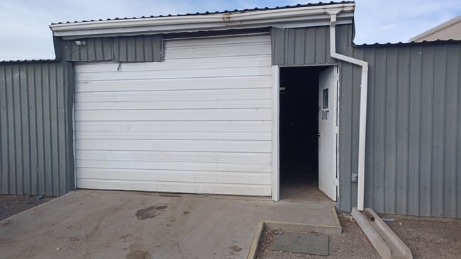
Warehouse
Adams
I2
Colorado
B and X Area of moderate flood hazard, usually the area between the limits of the 100-year and 500-year floods.
3.36 AC
2024
North Denver
2025
Denver
008802
Denver-Aurora-Centennial, CO
52,872 SF
NEARBY LISTINGS FOR SALE OR LEASE
DEMOGRAPHICS near 8777 Brighton Rd
1 mile
3 mile
5 mile
2025 Total Population
2,314
68,681
207,358
2030 Population
2,359
70,883
214,878
Pop Growth 2025-2030
+ 1.94%
+ 3.21%
+ 3.63%
Average Age
35
36
36
2025 Total Households
626
22,134
69,939
HH Growth 2025-2030
+ 2.24%
+ 3.50%
+ 3.91%
Median Household Inc
$70,679
$85,684
$90,227
Avg Household Size
3.40
3.00
2.90
2025 Avg HH Vehicles
3.00
2.00
2.00
Median Home Value
$87,606
$408,081
$448,248
Median Year Built
1988
1980
1986
Nearby Places
Map Layers
Map Styles
 Street
 Aerial
Transit
 Traffic
 Biking
Places
Listings with unknown addresses are not visible on the map
- Restaurants
- Banks
- Shops
- Fitness
- Groceries
PUBLIC TRANSPORTATION
AIRPORT
Denver International
Drive
Walk
Distance
Denver International
29 min
21.1 mi
SALE & LEASE HISTORY
LISTING DATE
SALE/LEASE

Mar 21, 2023
For Sale
Jan 05, 2020
For Lease
Dec 02, 2016
For Lease
Nearby Properties
Address
Land Use
TOTAL SIZE
Lot Size
Zoning
Address
Land Use
TOTAL SIZE
Lot Size
Zoning
295,558 SF
13.41 AC
Address
Land Use
TOTAL SIZE
Lot Size
Zoning
106,680 SF
17.39 AC
Address
Land Use
TOTAL SIZE
Lot Size
Zoning
140,328 SF
6.54 AC
PUD
Address
Land Use
TOTAL SIZE
Lot Size
Zoning
17,063 SF
2.01 AC
Address
Land Use
TOTAL SIZE
Lot Size
Zoning
649,540 SF
33.65 AC
Address
Land Use
TOTAL SIZE
Lot Size
Zoning
74,106 SF
3.95 AC
PUD
Address
Land Use
TOTAL SIZE
Lot Size
Zoning
296,000 SF
52.44 AC
A3
Address
Land Use
TOTAL SIZE
Lot Size
Zoning
549,866 SF
33.82 AC
Address
Land Use
TOTAL SIZE
Lot Size
Zoning
91,326 SF
5.09 AC
Address
Land Use
TOTAL SIZE
Lot Size
Zoning
94,213 SF
3.84 AC
A1
Address
Land Use
TOTAL SIZE
Lot Size
Zoning
85,738 SF
4.43 AC
Address
Land Use
TOTAL SIZE
Lot Size
Zoning
282,144 SF
4.01 AC
Address
Land Use
TOTAL SIZE
Lot Size
Zoning
616.10 AC
A3
Address
Land Use
TOTAL SIZE
Lot Size
Zoning
328,674 SF
47.13 AC
Address
Land Use
TOTAL SIZE
Lot Size
Zoning
329,940 SF
10.31 AC
Address
Land Use
TOTAL SIZE
Lot Size
Zoning
11,200 SF
36.45 AC
A1
Address
Land Use
TOTAL SIZE
Lot Size
Zoning
250,523 SF
70.73 AC
I1
Address
Land Use
TOTAL SIZE
Lot Size
Zoning
109,372 SF
13.18 AC
Address
Land Use
TOTAL SIZE
Lot Size
Zoning
172,816 SF
59.89 AC
Address
Land Use
TOTAL SIZE
Lot Size
Zoning
459,283 SF
16.88 AC
Address
Land Use
TOTAL SIZE
Lot Size
Zoning
258,279 SF
70.11 AC
I2
Address
Land Use
TOTAL SIZE
Lot Size
Zoning
219,959 SF
10 AC
Address
Land Use
TOTAL SIZE
Lot Size
Zoning
208,864 SF
19.26 AC
Address
Land Use
TOTAL SIZE
Lot Size
Zoning
312,218 SF
31.14 AC
Address
Land Use
TOTAL SIZE
Lot Size
Zoning
2,240 SF
128.54 AC
A1
Address
Land Use
TOTAL SIZE
Lot Size
Zoning
373,767 SF
18.87 AC
Address
Land Use
TOTAL SIZE
Lot Size
Zoning
199,500 SF
15.03 AC
Address
Land Use
TOTAL SIZE
Lot Size
Zoning
204,000 SF
9.96 AC
Address
Land Use
TOTAL SIZE
Lot Size
Zoning
71,966 SF
11.65 AC
R1C
Address
Land Use
TOTAL SIZE
Lot Size
Zoning
119,680 SF
10.10 AC
C5
The World's #1 Commercial Real Estate Marketplace
Connect with us
© 2026 CoStar Group
The information above has been obtained from sources believed reliable. While we do not doubt its accuracy we have not verified it and make no guarantee, warranty or representation about it. It is your responsibility to independently confirm its accuracy and completeness. Any projections, opinions, assumptions, or estimates used are for example only and do not represent the current or future performance of the property. The value of this transaction to you depends on tax and other factors which should be evaluated by your tax, financial, and legal advisors. You and your advisors should conduct a careful, independent investigation of the property to determine to your satisfaction the suitability of the property for your needs.