Property Record
8848 E Kings Canyon Rd, Sanger, CA 93657

Save to a Folder
{{folder.Name}}
{{folder.ListingIds.length}} Properties
{{folder.ListingIds.length}} Property
Create a New Folder
Property Detail
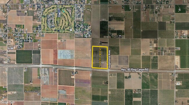
8848 E Kings Canyon Rd
313-030-50
11.36 AC IN E1/2 OF SE1/4 SEC 1 T14R21
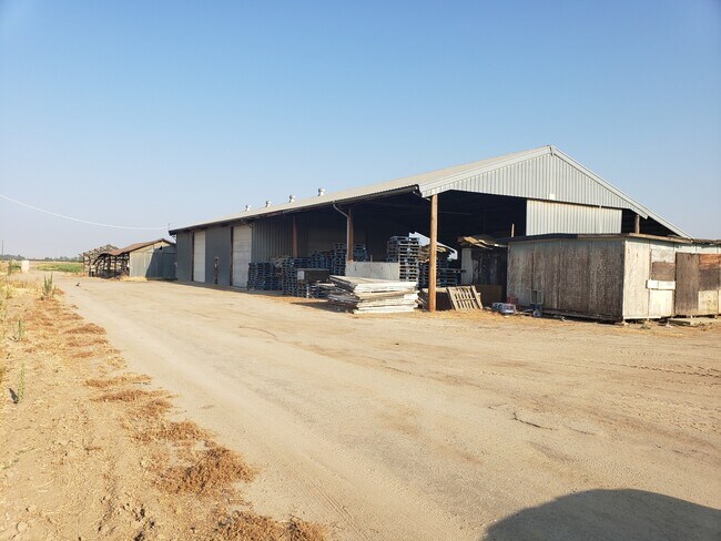
Farms
FRESNO
AE20
California
B and X Area of moderate flood hazard, usually the area between the limits of the 100-year and 500-year floods.
11.36 AC
2025
E Outlying Fresno County
2025
Fresno
006202
Fresno, CA
NEARBY LISTINGS FOR SALE OR LEASE
DEMOGRAPHICS near 8848 E Kings Canyon Rd
1 mile
3 mile
5 mile
2025 Total Population
417
16,616
116,694
2030 Population
432
17,254
119,601
Pop Growth 2025-2030
+ 3.60%
+ 3.84%
+ 2.49%
Average Age
39
36
36
2025 Total Households
129
4,680
34,089
HH Growth 2025-2030
+ 3.88%
+ 3.85%
+ 2.48%
Median Household Inc
$118,749
$112,799
$102,073
Avg Household Size
3.10
3.50
3.40
2025 Avg HH Vehicles
2.00
2.00
2.00
Median Home Value
$632,812
$452,769
$459,256
Median Year Built
1981
2005
2000
Nearby Places
Map Layers
Map Styles
 Street
 Aerial
Layers
 Traffic
 Biking
Places
Listings with unknown addresses are not visible on the map
- Restaurants
- Banks
- Shops
- Fitness
- Groceries
PUBLIC TRANSPORTATION
COMMUTER RAIL
Fresno (San Joaquins - Amtrak)
Drive
Walk
Distance
Fresno (San Joaquins - Amtrak)
12 min
9.8 mi
AIRPORT
Fresno Yosemite International
Drive
Walk
Distance
Fresno Yosemite International
10 min
6.8 mi
Freight Ports
Port of Stockton
Drive
Walk
Distance
Port of Stockton
161 min
136.8 mi
SALE & LEASE HISTORY
LISTING DATE
SALE/LEASE

Aug 25, 2021
For Sale
Aug 23, 2021
For Sale
Nearby Properties
Address
Land Use
TOTAL SIZE
Lot Size
Zoning
Address
Land Use
TOTAL SIZE
Lot Size
Zoning
177,312 SF
28.12 AC
R1
Address
Land Use
TOTAL SIZE
Lot Size
Zoning
216,342 SF
28.49 AC
Address
Land Use
TOTAL SIZE
Lot Size
Zoning
102,765 SF
8.90 AC
M1
Address
Land Use
TOTAL SIZE
Lot Size
Zoning
76,720 SF
10.78 AC
Address
Land Use
TOTAL SIZE
Lot Size
Zoning
69,015 SF
8.15 AC
C1
Address
Land Use
TOTAL SIZE
Lot Size
Zoning
150,080 SF
7.99 AC
M1
Address
Land Use
TOTAL SIZE
Lot Size
Zoning
25,600 SF
1.99 AC
IL
Address
Land Use
TOTAL SIZE
Lot Size
Zoning
158.81 AC
AE20
Address
Land Use
TOTAL SIZE
Lot Size
Zoning
924 SF
154 AC
AE20
Address
Land Use
TOTAL SIZE
Lot Size
Zoning
16,671 SF
1.53 AC
C2
Address
Land Use
TOTAL SIZE
Lot Size
Zoning
12,527 SF
3.97 AC
C2
Address
Land Use
TOTAL SIZE
Lot Size
Zoning
153,312 SF
15.02 AC
IL
Address
Land Use
TOTAL SIZE
Lot Size
Zoning
156.04 AC
AE20
Address
Land Use
TOTAL SIZE
Lot Size
Zoning
32,070 SF
109.34 AC
RR
Address
Land Use
TOTAL SIZE
Lot Size
Zoning
73,577 SF
25.18 AC
AE20
Address
Land Use
TOTAL SIZE
Lot Size
Zoning
27,340 SF
1.62 AC
M1
Address
Land Use
TOTAL SIZE
Lot Size
Zoning
51,744 SF
3.24 AC
M1
Address
Land Use
TOTAL SIZE
Lot Size
Zoning
5,088 SF
31.46 AC
AE20
Address
Land Use
TOTAL SIZE
Lot Size
Zoning
28,304 SF
2.56 AC
IL
Address
Land Use
TOTAL SIZE
Lot Size
Zoning
1,058 SF
77.22 AC
AE20
Address
Land Use
TOTAL SIZE
Lot Size
Zoning
890 SF
39.26 AC
AE20
Address
Land Use
TOTAL SIZE
Lot Size
Zoning
4,828 SF
29.30 AC
AE20
Address
Land Use
TOTAL SIZE
Lot Size
Zoning
94,589 SF
20.81 AC
AE20
Address
Land Use
TOTAL SIZE
Lot Size
Zoning
40 AC
AE20
Address
Land Use
TOTAL SIZE
Lot Size
Zoning
39.55 AC
AE20
Address
Land Use
TOTAL SIZE
Lot Size
Zoning
15,500 SF
0.91 AC
M1
Address
Land Use
TOTAL SIZE
Lot Size
Zoning
35,000 SF
2.77 AC
IL
The World's #1 Commercial Real Estate Marketplace
Connect with us
© 2026 CoStar Group
The information above has been obtained from sources believed reliable. While we do not doubt its accuracy we have not verified it and make no guarantee, warranty or representation about it. It is your responsibility to independently confirm its accuracy and completeness. Any projections, opinions, assumptions, or estimates used are for example only and do not represent the current or future performance of the property. The value of this transaction to you depends on tax and other factors which should be evaluated by your tax, financial, and legal advisors. You and your advisors should conduct a careful, independent investigation of the property to determine to your satisfaction the suitability of the property for your needs.