Property Record
885 Louis Dr, Warminster, PA 18974

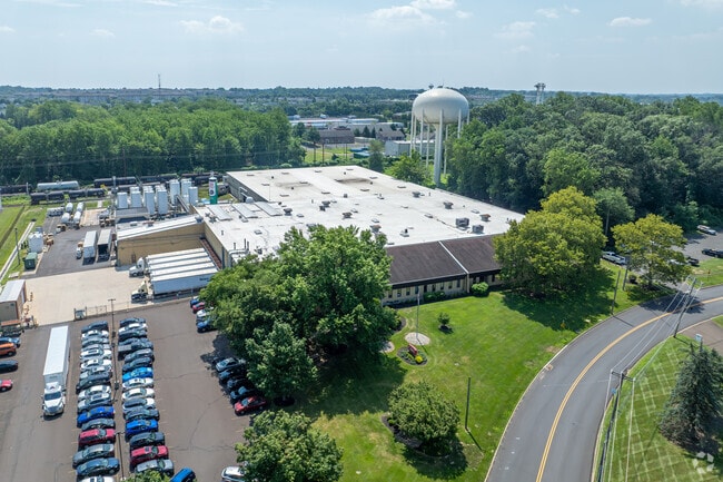
Property Detail
885 Louis Dr
49-009-079-008
4.544AC LOT#1A SS LOUIS D R 2407FT E OF STREET RD
Warehouse
Bucks
I
Pennsylvania
B and X Area of moderate flood hazard, usually the area between the limits of the 100-year and 500-year floods.
1
2024
6.41 AC
2025
Bucks
101609
Philadelphia
96,927 SF
Philadelphia-Camden-Wilmington, PA-NJ-DE-MD
NEARBY LISTINGS FOR SALE OR LEASE
DEMOGRAPHICS near 885 Louis Dr
1 mile
3 mile
5 mile
2025 Total Population
10,161
82,962
169,633
2030 Population
10,349
84,225
172,210
Pop Growth 2025-2030
+ 1.85%
+ 1.52%
+ 1.52%
Average Age
49
45
44
2025 Total Households
4,528
33,338
65,270
HH Growth 2025-2030
+ 1.57%
+ 1.64%
+ 1.71%
Median Household Inc
$91,007
$98,211
$109,401
Avg Household Size
2.20
2.40
2.50
2025 Avg HH Vehicles
2.00
2.00
2.00
Median Home Value
$418,896
$432,185
$457,755
Median Year Built
1984
1970
1972
Nearby Places
Map Layers
Map Styles
 Street
 Aerial
Layers
 Traffic
 Biking
Places
Listings with unknown addresses are not visible on the map
- Restaurants
- Banks
- Shops
- Fitness
- Groceries
PUBLIC TRANSPORTATION
COMMUTER RAIL
Warminster (R2 - Southeastern Pennsylvania Transportation Authority Regional Rail (SEPTA Regional Rail))
Drive
Walk
Distance
Warminster (R2 - Southeastern Pennsylvania Transportation Authority Regional Rail (SEPTA Regional Rail))
4 min
1.1 mi
Hatboro (R2 - Southeastern Pennsylvania Transportation Authority Regional Rail (SEPTA Regional Rail))
Drive
Walk
Distance
Hatboro (R2 - Southeastern Pennsylvania Transportation Authority Regional Rail (SEPTA Regional Rail))
7 min
2.9 mi
AIRPORT
Trenton Mercer
Drive
Walk
Distance
Trenton Mercer
36 min
19.6 mi
Philadelphia International
Drive
Walk
Distance
Philadelphia International
60 min
37.5 mi
Lehigh Valley International
Drive
Walk
Distance
Lehigh Valley International
75 min
43.0 mi
Freight Ports
Port of Philadelphia
Drive
Walk
Distance
Port of Philadelphia
39 min
20.0 mi
Nearby Properties
Address
Land Use
TOTAL SIZE
Lot Size
Zoning
Address
Land Use
TOTAL SIZE
Lot Size
Zoning
377,044 SF
58.73 AC
INST
Address
Land Use
TOTAL SIZE
Lot Size
Zoning
571,213 SF
67.31 AC
M
Address
Land Use
TOTAL SIZE
Lot Size
Zoning
251,655 SF
48.95 AC
SC
Address
Land Use
TOTAL SIZE
Lot Size
Zoning
256,679 SF
14 AC
MI
Address
Land Use
TOTAL SIZE
Lot Size
Zoning
420,736 SF
29.47 AC
LI
Address
Land Use
TOTAL SIZE
Lot Size
Zoning
344,636 SF
25.02 AC
R7
Address
Land Use
TOTAL SIZE
Lot Size
Zoning
110,198 SF
12.18 AC
R2
Address
Land Use
TOTAL SIZE
Lot Size
Zoning
182,364 SF
21.06 AC
M
Address
Land Use
TOTAL SIZE
Lot Size
Zoning
160,798 SF
37.55 AC
R4
Address
Land Use
TOTAL SIZE
Lot Size
Zoning
240,682 SF
4.81 AC
HI
Address
Land Use
TOTAL SIZE
Lot Size
Zoning
60,945 SF
74.12 AC
Address
Land Use
TOTAL SIZE
Lot Size
Zoning
125,387 SF
4.10 AC
RC2
Address
Land Use
TOTAL SIZE
Lot Size
Zoning
106,412 SF
13.52 AC
M
Address
Land Use
TOTAL SIZE
Lot Size
Zoning
162,363 SF
2.72 AC
HI
Address
Land Use
TOTAL SIZE
Lot Size
Zoning
91,446 SF
2.53 AC
R7
Address
Land Use
TOTAL SIZE
Lot Size
Zoning
269,481 SF
23.79 AC
SC1
Address
Land Use
TOTAL SIZE
Lot Size
Zoning
257,048 SF
36.13 AC
C
Address
Land Use
TOTAL SIZE
Lot Size
Zoning
74,764 SF
10.17 AC
SC
Address
Land Use
TOTAL SIZE
Lot Size
Zoning
58,318 SF
20.12 AC
R4
Address
Land Use
TOTAL SIZE
Lot Size
Zoning
29,308 SF
15.96 AC
I
Address
Land Use
TOTAL SIZE
Lot Size
Zoning
87,120 SF
1.51 AC
RC2
Address
Land Use
TOTAL SIZE
Lot Size
Zoning
72,852 SF
21.24 AC
R2
Address
Land Use
TOTAL SIZE
Lot Size
Zoning
59,133 SF
6.67 AC
LC3
Address
Land Use
TOTAL SIZE
Lot Size
Zoning
56,668 SF
3.68 AC
R4
Address
Land Use
TOTAL SIZE
Lot Size
Zoning
25,572 SF
3.42 AC
R2
Address
Land Use
TOTAL SIZE
Lot Size
Zoning
19,474 SF
17 AC
R4
Address
Land Use
TOTAL SIZE
Lot Size
Zoning
90,670 SF
9.93 AC
M
Address
Land Use
TOTAL SIZE
Lot Size
Zoning
37,806 SF
21.50 AC
R5
Address
Land Use
TOTAL SIZE
Lot Size
Zoning
25,021 SF
10.82 AC
I
The World's #1 Commercial Real Estate Marketplace
Connect with us
© 2026 CoStar Group
The information above has been obtained from sources believed reliable. While we do not doubt its accuracy we have not verified it and make no guarantee, warranty or representation about it. It is your responsibility to independently confirm its accuracy and completeness. Any projections, opinions, assumptions, or estimates used are for example only and do not represent the current or future performance of the property. The value of this transaction to you depends on tax and other factors which should be evaluated by your tax, financial, and legal advisors. You and your advisors should conduct a careful, independent investigation of the property to determine to your satisfaction the suitability of the property for your needs.