Property Record
8855 Immokalee Rd, Naples, FL 34120

Save to a Folder
{{folder.Name}}
{{folder.ListingIds.length}} Properties
{{folder.ListingIds.length}} Property
Create a New Folder
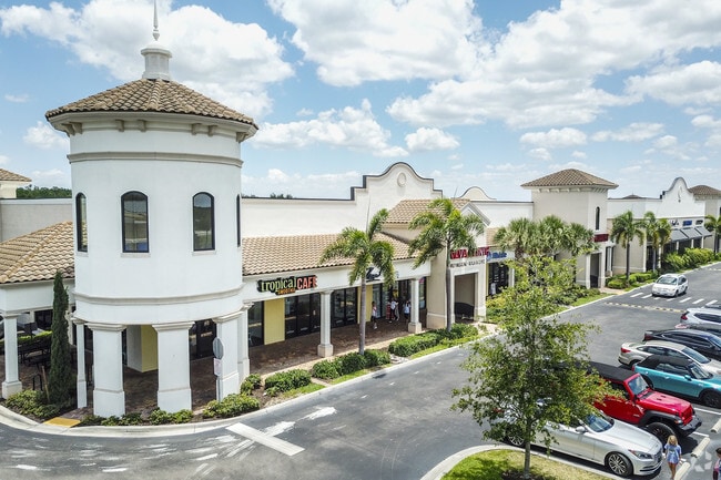
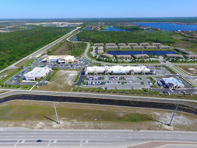
Property Detail
8855 Immokalee Rd
25118010080
CAMERON COMMONS UNIT ONE TRACT 4
Regionalshoppingcenterormallwithanchorstore
COLLIER
PUD
Florida
AE The base floodplain where base flood elevations are provided. AE Zones are now used on new format FIRMs instead of A1-A30 Zones.
1
2024
4.86 AC
2025
Outlying Collier County
011210
Southwest Florida
31,854 SF
Naples-Marco Island, FL
NEARBY LISTINGS FOR SALE OR LEASE
DEMOGRAPHICS near 8855 Immokalee Rd
1 mile
3 mile
5 mile
2025 Total Population
6,828
35,524
83,665
2030 Population
7,396
38,308
90,641
Pop Growth 2025-2030
+ 8.32%
+ 7.84%
+ 8.34%
Average Age
41
46
50
2025 Total Households
2,511
13,844
35,292
HH Growth 2025-2030
+ 7.73%
+ 7.20%
+ 7.94%
Median Household Inc
$104,366
$106,325
$106,227
Avg Household Size
2.60
2.50
2.30
2025 Avg HH Vehicles
2.00
2.00
2.00
Median Home Value
$659,139
$704,261
$691,338
Median Year Built
2009
2007
2005
Nearby Places
Map Layers
Map Styles
 Street
 Aerial
Layers
 Traffic
 Biking
Places
Listings with unknown addresses are not visible on the map
- Restaurants
- Banks
- Shops
- Fitness
- Groceries
PUBLIC TRANSPORTATION
AIRPORT
Southwest Florida International
Drive
Walk
Distance
Southwest Florida International
35 min
26.5 mi
Freight Ports
Port Everglades
Drive
Walk
Distance
Port Everglades
124 min
107.8 mi
SALE & LEASE HISTORY
LISTING DATE
SALE/LEASE

Sep 25, 2016
For Lease
Nov 27, 2018
For Lease
Jan 13, 2020
For Lease
Nearby Properties
Address
Land Use
TOTAL SIZE
Lot Size
Zoning
Address
Land Use
TOTAL SIZE
Lot Size
Zoning
465,208 SF
17.72 AC
Address
Land Use
TOTAL SIZE
Lot Size
Zoning
463,985 SF
28.48 AC
Address
Land Use
TOTAL SIZE
Lot Size
Zoning
312,140 SF
15 AC
Address
Land Use
TOTAL SIZE
Lot Size
Zoning
275,219 SF
16.20 AC
Address
Land Use
TOTAL SIZE
Lot Size
Zoning
376,493 SF
65.03 AC
RSF-3
Address
Land Use
TOTAL SIZE
Lot Size
Zoning
52,982 SF
10.58 AC
Address
Land Use
TOTAL SIZE
Lot Size
Zoning
142,737 SF
37.48 AC
A
Address
Land Use
TOTAL SIZE
Lot Size
Zoning
50,994 SF
37.60 AC
A-MHO
Address
Land Use
TOTAL SIZE
Lot Size
Zoning
41,465 SF
3.36 AC
PUD
Address
Land Use
TOTAL SIZE
Lot Size
Zoning
115,552 SF
13.20 AC
PUD
Address
Land Use
TOTAL SIZE
Lot Size
Zoning
104,470 SF
13.06 AC
PUD
Address
Land Use
TOTAL SIZE
Lot Size
Zoning
22,099 SF
7.73 AC
PUD
Address
Land Use
TOTAL SIZE
Lot Size
Zoning
113,867 SF
6.90 AC
PUD
Address
Land Use
TOTAL SIZE
Lot Size
Zoning
86,254 SF
18.57 AC
A
Address
Land Use
TOTAL SIZE
Lot Size
Zoning
54,140 SF
50.66 AC
PUD
Address
Land Use
TOTAL SIZE
Lot Size
Zoning
46,820 SF
7.02 AC
PUD
Address
Land Use
TOTAL SIZE
Lot Size
Zoning
39,728 SF
5.74 AC
Address
Land Use
TOTAL SIZE
Lot Size
Zoning
61,688 SF
2.65 AC
Address
Land Use
TOTAL SIZE
Lot Size
Zoning
40,045 SF
35.33 AC
A-MHO
Address
Land Use
TOTAL SIZE
Lot Size
Zoning
59,616 SF
2.51 AC
Address
Land Use
TOTAL SIZE
Lot Size
Zoning
84,474 SF
18.16 AC
PUD
Address
Land Use
TOTAL SIZE
Lot Size
Zoning
35,947 SF
17.33 AC
A
Address
Land Use
TOTAL SIZE
Lot Size
Zoning
80,145 SF
9.30 AC
PUD
Address
Land Use
TOTAL SIZE
Lot Size
Zoning
110,133 SF
2.30 AC
Address
Land Use
TOTAL SIZE
Lot Size
Zoning
92,070 SF
2.37 AC
Address
Land Use
TOTAL SIZE
Lot Size
Zoning
104,640 SF
1.82 AC
Address
Land Use
TOTAL SIZE
Lot Size
Zoning
42,231 SF
1,027.79 AC
A-MHO
Address
Land Use
TOTAL SIZE
Lot Size
Zoning
61,585 SF
4.15 AC
PUD
Address
Land Use
TOTAL SIZE
Lot Size
Zoning
34,040 SF
2.74 AC
Address
Land Use
TOTAL SIZE
Lot Size
Zoning
36,740 SF
3.43 AC
The World's #1 Commercial Real Estate Marketplace
Connect with us
© 2026 CoStar Group
The information above has been obtained from sources believed reliable. While we do not doubt its accuracy we have not verified it and make no guarantee, warranty or representation about it. It is your responsibility to independently confirm its accuracy and completeness. Any projections, opinions, assumptions, or estimates used are for example only and do not represent the current or future performance of the property. The value of this transaction to you depends on tax and other factors which should be evaluated by your tax, financial, and legal advisors. You and your advisors should conduct a careful, independent investigation of the property to determine to your satisfaction the suitability of the property for your needs.