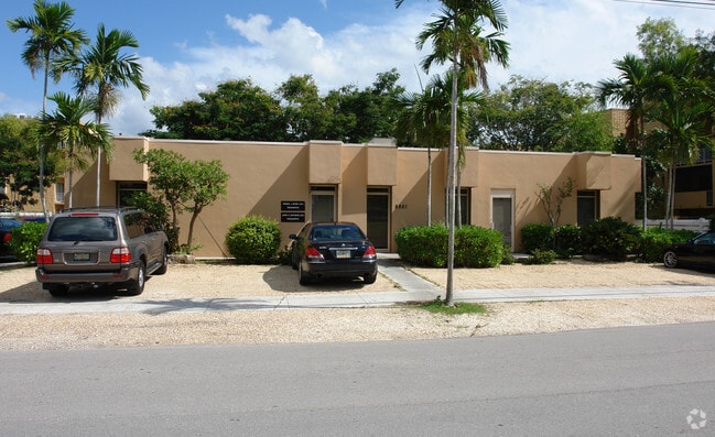
Property Record
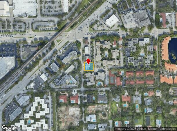
8861 Sw 69Th Ct, Pinecrest, FL 33156

NEARBY LISTINGS FOR SALE OR LEASE
Property Detail
8861 Sw 69Th Ct
Miami-Miami Beach-Kendall, FL
North Kendall
20-5002-005-0040
2 55 40 .24 AC NORTH KENDALL PB 44-93 LOT 3 LESS N19.35FT & LOT 4 LESS S40.81FT BLK 1 F/A/U 30-5002-005-0040 OR 18487-0975 0199 4
Officebuilding
Miami/Dade
X
Florida
12086C0458L
3,4
2024
0.25 AC
2025
Kendall
007807
South Florida
2,970 SF
DEMOGRAPHICS near 8861 Sw 69Th Ct
1 Mile
3 Mile
5 Mile
2024 Total Population
25,003
95,896
272,161
2029 Population
24,918
94,233
265,909
Pop Growth 2024-2029
(0.34%)
(1.73%)
(2.30%)
Average Age
41
41
43
2024 Total Households
12,123
36,736
100,498
HH Growth 2024-2029
(0.56%)
(1.92%)
(2.44%)
Median Household Inc
$65,590
$92,441
$85,492
Avg Household Size
2.00
2.50
2.60
2024 Avg HH Vehicles
1.00
2.00
2.00
Median Home Value
$447,311
$718,856
$542,502
Median Year Built
1983
1974
1972
Nearby Places
Map Layers
Map Styles
 Street
 Aerial
- Restaurants
- Banks
- Shops
- Fitness
- Groceries
PUBLIC TRANSPORTATION
TRANSIT/SUBWAY
Dadeland South (Metrorail Green Line - Miami-Dade Transit (Metrorail/Metromover))
DRIVE
WALK
Distance
Dadeland South (Metrorail Green Line - Miami-Dade Transit (Metrorail/Metromover))
2 min
9 min
0.5 mi
Dadeland North (Metrorail Green Line - Miami-Dade Transit (Metrorail/Metromover))
DRIVE
WALK
Distance
Dadeland North (Metrorail Green Line - Miami-Dade Transit (Metrorail/Metromover))
2 min
15 min
0.7 mi
COMMUTER RAIL
Dadeland North (Metrorail Green Line - Miami-Dade Transit (Metrorail/Metromover))
DRIVE
WALK
Distance
Dadeland North (Metrorail Green Line - Miami-Dade Transit (Metrorail/Metromover))
2 min
7 min
0.4 mi
Dadeland South (Metrorail Green Line - Miami-Dade Transit (Metrorail/Metromover))
DRIVE
WALK
Distance
Dadeland South (Metrorail Green Line - Miami-Dade Transit (Metrorail/Metromover))
2 min
10 min
0.5 mi
AIRPORT
Miami International
DRIVE
WALK
Distance
Miami International
21 min
10.7 mi
Fort Lauderdale/Hollywood International
DRIVE
WALK
Distance
Fort Lauderdale/Hollywood International
49 min
32.8 mi
Nearby Properties
Address
Land Use
TOTAL SIZE
Lot Size
Zoning
Address
Land Use
TOTAL SIZE
Lot Size
Zoning
2,238,641 SF
39 AC
6114
Address
Land Use
TOTAL SIZE
Lot Size
Zoning
1,018,683 SF
11.46 AC
5000
Address
Land Use
TOTAL SIZE
Lot Size
Zoning
883,561 SF
5.63 AC
8200
Address
Land Use
TOTAL SIZE
Lot Size
Zoning
1,527,515 SF
55.17 AC
5000
Address
Land Use
TOTAL SIZE
Lot Size
Zoning
877,136 SF
2.96 AC
6112
Address
Land Use
TOTAL SIZE
Lot Size
Zoning
715,755 SF
2.66 AC
5005
Address
Land Use
TOTAL SIZE
Lot Size
Zoning
973,728 SF
76.18 AC
8200
Address
Land Use
TOTAL SIZE
Lot Size
Zoning
766,093 SF
8.91 AC
5000
Address
Land Use
TOTAL SIZE
Lot Size
Zoning
764,501 SF
1.81 AC
6114
Address
Land Use
TOTAL SIZE
Lot Size
Zoning
644,929 SF
1.10 AC
6114
Address
Land Use
TOTAL SIZE
Lot Size
Zoning
759,863 SF
7.02 AC
6506
Address
Land Use
TOTAL SIZE
Lot Size
Zoning
634,144 SF
3.12 AC
6114
Address
Land Use
TOTAL SIZE
Lot Size
Zoning
500,332 SF
3.46 AC
6000
Address
Land Use
TOTAL SIZE
Lot Size
Zoning
521,667 SF
1.08 AC
6112
Address
Land Use
TOTAL SIZE
Lot Size
Zoning
532,779 SF
0000
Address
Land Use
TOTAL SIZE
Lot Size
Zoning
365,003 SF
15.05 AC
8200
Address
Land Use
TOTAL SIZE
Lot Size
Zoning
14.30 AC
0700
Address
Land Use
TOTAL SIZE
Lot Size
Zoning
859,337 SF
0.13 AC
7100
Address
Land Use
TOTAL SIZE
Lot Size
Zoning
516,656 SF
9.65 AC
6300
Address
Land Use
TOTAL SIZE
Lot Size
Zoning
364,114 SF
20 AC
3100
Address
Land Use
TOTAL SIZE
Lot Size
Zoning
432,416 SF
1.67 AC
5004
Address
Land Use
TOTAL SIZE
Lot Size
Zoning
452,547 SF
0.90 AC
6114
Address
Land Use
TOTAL SIZE
Lot Size
Zoning
705,929 SF
7.05 AC
9600
Address
Land Use
TOTAL SIZE
Lot Size
Zoning
553,491 SF
10.64 AC
3900
Address
Land Use
TOTAL SIZE
Lot Size
Zoning
370,938 SF
1.58 AC
6112
Address
Land Use
TOTAL SIZE
Lot Size
Zoning
277,025 SF
0.01 AC
6114
Address
Land Use
TOTAL SIZE
Lot Size
Zoning
129,079 SF
4 AC
6114
Address
Land Use
TOTAL SIZE
Lot Size
Zoning
327,378 SF
0.14 AC
7600
Address
Land Use
TOTAL SIZE
Lot Size
Zoning
309,432 SF
272.32 AC
8900
Address
Land Use
TOTAL SIZE
Lot Size
Zoning
304,771 SF
1.81 AC
5003
The World's #1 Commercial Real Estate Marketplace
Connect with us
© 2026 CoStar Group
The information above has been obtained from sources believed reliable. While we do not doubt its accuracy we have not verified it and make no guarantee, warranty or representation about it. It is your responsibility to independently confirm its accuracy and completeness. Any projections, opinions, assumptions, or estimates used are for example only and do not represent the current or future performance of the property. The value of this transaction to you depends on tax and other factors which should be evaluated by your tax, financial, and legal advisors. You and your advisors should conduct a careful, independent investigation of the property to determine to your satisfaction the suitability of the property for your needs.