Property Record
8913 E Interstate 20 E, Midland, TX 79706
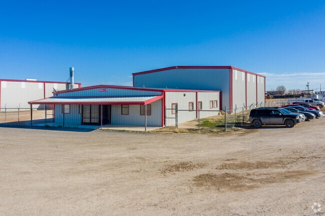

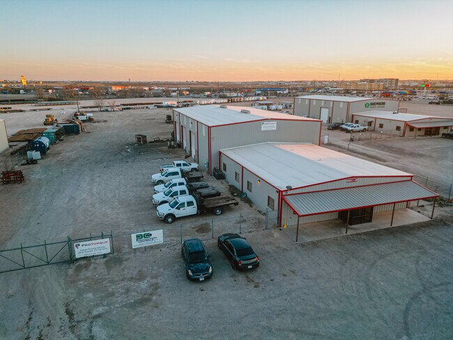
Property Detail
8913 E Interstate 20 E
Midland, TX
ACRES: 3.440 S/2 SEC: 16 BLK: 40-T2S AKA TR 25
R000211-701
MIDLAND
Officebuilding
Texas
2025
3.44 AC
2025
Midland & Odessa
010127
Other Market Areas
2,500 SF
NEARBY LISTINGS FOR SALE OR LEASE
DEMOGRAPHICS near 8913 E Interstate 20 E
1 mile
3 mile
5 mile
2024 Total Population
257
20,563
62,012
2029 Population
274
21,347
63,791
Pop Growth 2024-2029
+ 6.61%
+ 3.81%
+ 2.87%
Average Age
31
34
35
2024 Total Households
92
6,635
21,242
HH Growth 2024-2029
+ 7.61%
+ 4.17%
+ 3.21%
Median Household Inc
$29,999
$44,035
$62,545
Avg Household Size
2.80
2.90
2.80
2024 Avg HH Vehicles
2.00
2.00
2.00
Median Home Value
$323,684
$214,186
$235,209
Median Year Built
2002
1987
1977
Nearby Places
Map Layers
Map Styles
 Street
 Aerial
Transit
 Traffic
 Biking
Places
Listings with unknown addresses are not visible on the map
- Restaurants
- Banks
- Shops
- Fitness
- Groceries
PUBLIC TRANSPORTATION
AIRPORT
Midland International Air And Space Port
Drive
Walk
Distance
Midland International Air And Space Port
18 min
10.9 mi
SALE & LEASE HISTORY
LISTING DATE
SALE/LEASE

Jul 22, 2019
For Lease
Nearby Properties
Address
Land Use
TOTAL SIZE
Lot Size
Zoning
Address
Land Use
TOTAL SIZE
Lot Size
Zoning
145,200 SF
293.40 AC
IP3
Address
Land Use
TOTAL SIZE
Lot Size
Zoning
12,420 SF
40.94 AC
Address
Land Use
TOTAL SIZE
Lot Size
Zoning
1,338 SF
16.81 AC
IP3
Address
Land Use
TOTAL SIZE
Lot Size
Zoning
25,899 SF
13.68 AC
Address
Land Use
TOTAL SIZE
Lot Size
Zoning
300,000 SF
20.01 AC
Address
Land Use
TOTAL SIZE
Lot Size
Zoning
11,100 SF
71.86 AC
Address
Land Use
TOTAL SIZE
Lot Size
Zoning
2,850 SF
321.48 AC
IP3
Address
Land Use
TOTAL SIZE
Lot Size
Zoning
40,960 SF
18.61 AC
Address
Land Use
TOTAL SIZE
Lot Size
Zoning
175.09 AC
Address
Land Use
TOTAL SIZE
Lot Size
Zoning
21,269 SF
3 AC
FD
Address
Land Use
TOTAL SIZE
Lot Size
Zoning
22,600 SF
4.74 AC
FD
Address
Land Use
TOTAL SIZE
Lot Size
Zoning
20,790 SF
19.47 AC
IP3
Address
Land Use
TOTAL SIZE
Lot Size
Zoning
28,350 SF
11.69 AC
IP2
Address
Land Use
TOTAL SIZE
Lot Size
Zoning
205,991 SF
23.82 AC
Address
Land Use
TOTAL SIZE
Lot Size
Zoning
800 SF
29.62 AC
Address
Land Use
TOTAL SIZE
Lot Size
Zoning
2,400 SF
6.50 AC
Address
Land Use
TOTAL SIZE
Lot Size
Zoning
27,700 SF
5.58 AC
Address
Land Use
TOTAL SIZE
Lot Size
Zoning
6,000 SF
38.47 AC
Address
Land Use
TOTAL SIZE
Lot Size
Zoning
3,500 SF
12 AC
Address
Land Use
TOTAL SIZE
Lot Size
Zoning
924 SF
5.36 AC
IP2
Address
Land Use
TOTAL SIZE
Lot Size
Zoning
22,807 SF
5.53 AC
IP2
Address
Land Use
TOTAL SIZE
Lot Size
Zoning
42,500 SF
14.95 AC
Address
Land Use
TOTAL SIZE
Lot Size
Zoning
23,300 SF
8 AC
Address
Land Use
TOTAL SIZE
Lot Size
Zoning
2,000 SF
12 AC
Address
Land Use
TOTAL SIZE
Lot Size
Zoning
318.31 AC
Address
Land Use
TOTAL SIZE
Lot Size
Zoning
119.26 AC
Address
Land Use
TOTAL SIZE
Lot Size
Zoning
486.40 AC
Address
Land Use
TOTAL SIZE
Lot Size
Zoning
18,410 SF
8.40 AC
Address
Land Use
TOTAL SIZE
Lot Size
Zoning
9,318 SF
10 AC
O1
Address
Land Use
TOTAL SIZE
Lot Size
Zoning
114.74 AC
The World's #1 Commercial Real Estate Marketplace
Connect with us
© 2026 CoStar Group
The information above has been obtained from sources believed reliable. While we do not doubt its accuracy we have not verified it and make no guarantee, warranty or representation about it. It is your responsibility to independently confirm its accuracy and completeness. Any projections, opinions, assumptions, or estimates used are for example only and do not represent the current or future performance of the property. The value of this transaction to you depends on tax and other factors which should be evaluated by your tax, financial, and legal advisors. You and your advisors should conduct a careful, independent investigation of the property to determine to your satisfaction the suitability of the property for your needs.