Property Record
899 S 6Th Ave, Wauchula, FL 33873

NEARBY LISTINGS FOR SALE OR LEASE
Property Detail
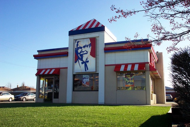
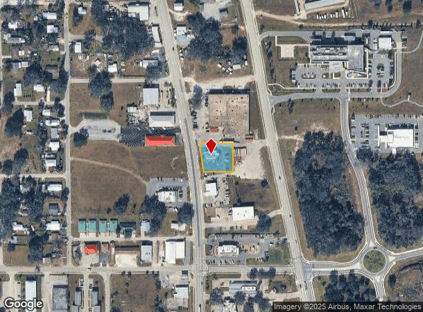
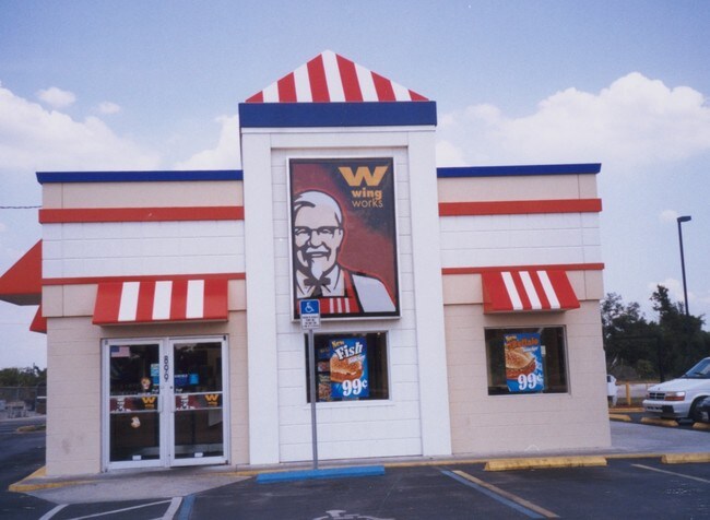
899 S 6Th Ave
1034-25-0000-00780-0000
Lake View High Pines
Restaurantdrivein
.56 AC COM AT NW COR OF S1/2 OF SW1/4 OF NW1/4 & RUN S 74.2 FT W 11.45 FT TO A PT ON E/LY R/W OF US 17 FOR POB E 168 FT SE/LY 143.45 FT W 168 FT NW/LY 144.93 FT TO POB 10 34S 25E 147P340 REGISTRARS NO.40-103 293P55 DC-322P728 418P398-426 (PROBATE) 41
X
Hardee
12049C0191D
Florida
2025
0.56 AC
2025
Florida Central South Area
970401
Other Market Areas
1,800 SF
DEMOGRAPHICS near 899 S 6Th Ave
1 mile
3 mile
5 mile
2024 Total Population
4,793
9,558
14,770
2029 Population
4,880
9,730
15,022
Pop Growth 2024-2029
+ 1.82%
+ 1.80%
+ 1.71%
Average Age
36
37
37
2024 Total Households
1,576
3,194
4,982
HH Growth 2024-2029
+ 1.90%
+ 1.91%
+ 1.83%
Median Household Inc
$25,613
$34,015
$41,155
Avg Household Size
2.90
2.90
2.90
2024 Avg HH Vehicles
2.00
2.00
2.00
Median Home Value
$88,597
$119,488
$139,301
Median Year Built
1979
1978
1979
Nearby Places
Map Layers
Map Styles
 Street
 Aerial
Transit
 Traffic
 Biking
Places
Listings with unknown addresses are not visible on the map
- Restaurants
- Banks
- Shops
- Fitness
- Groceries
Nearby Properties
Address
Land Use
TOTAL SIZE
Lot Size
Zoning
Address
Land Use
TOTAL SIZE
Lot Size
Zoning
25 AC
F-R
Address
Land Use
TOTAL SIZE
Lot Size
Zoning
22.21 AC
P-SP
Address
Land Use
TOTAL SIZE
Lot Size
Zoning
47,399 SF
55.51 AC
C-2
Address
Land Use
TOTAL SIZE
Lot Size
Zoning
50,071 SF
9.78 AC
C-2
Address
Land Use
TOTAL SIZE
Lot Size
Zoning
59,117 SF
70 AC
A-1
Address
Land Use
TOTAL SIZE
Lot Size
Zoning
107,610 SF
14.32 AC
C-1
Address
Land Use
TOTAL SIZE
Lot Size
Zoning
45,018 SF
17.48 AC
P-SP
Address
Land Use
TOTAL SIZE
Lot Size
Zoning
40,161 SF
4.48 AC
C-1
Address
Land Use
TOTAL SIZE
Lot Size
Zoning
16,132 SF
71.75 AC
F-R
Address
Land Use
TOTAL SIZE
Lot Size
Zoning
104,690 SF
9.96 AC
F-R
Address
Land Use
TOTAL SIZE
Lot Size
Zoning
89,500 SF
6.80 AC
C-2
Address
Land Use
TOTAL SIZE
Lot Size
Zoning
54,007 SF
9 AC
P-SP
Address
Land Use
TOTAL SIZE
Lot Size
Zoning
13.28 AC
F-R
Address
Land Use
TOTAL SIZE
Lot Size
Zoning
47,374 SF
1.79 AC
P-SP
Address
Land Use
TOTAL SIZE
Lot Size
Zoning
28.95 AC
P-SP
Address
Land Use
TOTAL SIZE
Lot Size
Zoning
432 SF
9.75 AC
P-SP
Address
Land Use
TOTAL SIZE
Lot Size
Zoning
37,017 SF
100 AC
P-R
Address
Land Use
TOTAL SIZE
Lot Size
Zoning
60,546 SF
14.57 AC
R-3
Address
Land Use
TOTAL SIZE
Lot Size
Zoning
35,140 SF
2.02 AC
P-SP
Address
Land Use
TOTAL SIZE
Lot Size
Zoning
65,778 SF
7.46 AC
F-R
Address
Land Use
TOTAL SIZE
Lot Size
Zoning
330.48 AC
A-1
Address
Land Use
TOTAL SIZE
Lot Size
Zoning
53,214 SF
12.50 AC
R-1A
Address
Land Use
TOTAL SIZE
Lot Size
Zoning
26,155 SF
8.86 AC
A-1
Address
Land Use
TOTAL SIZE
Lot Size
Zoning
80,371 SF
7.52 AC
C-2
Address
Land Use
TOTAL SIZE
Lot Size
Zoning
38,275 SF
18.72 AC
C-2
Address
Land Use
TOTAL SIZE
Lot Size
Zoning
54,583 SF
7.91 AC
C-2
Address
Land Use
TOTAL SIZE
Lot Size
Zoning
6,970 SF
53.50 AC
A-1
Address
Land Use
TOTAL SIZE
Lot Size
Zoning
35,537 SF
30 AC
F-R
Address
Land Use
TOTAL SIZE
Lot Size
Zoning
27,168 SF
3.62 AC
C-1
Address
Land Use
TOTAL SIZE
Lot Size
Zoning
29,145 SF
0.80 AC
HC-1
The World's #1 Commercial Real Estate Marketplace
Connect with us
© 2026 CoStar Group
The information above has been obtained from sources believed reliable. While we do not doubt its accuracy we have not verified it and make no guarantee, warranty or representation about it. It is your responsibility to independently confirm its accuracy and completeness. Any projections, opinions, assumptions, or estimates used are for example only and do not represent the current or future performance of the property. The value of this transaction to you depends on tax and other factors which should be evaluated by your tax, financial, and legal advisors. You and your advisors should conduct a careful, independent investigation of the property to determine to your satisfaction the suitability of the property for your needs.