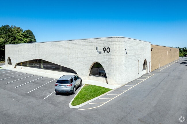
Property Record
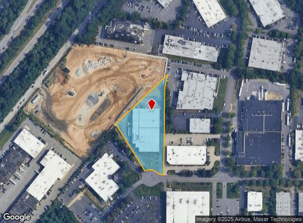
90 Davids Dr, Hauppauge, NY 11788
NEARBY LISTINGS FOR SALE OR LEASE
Property Detail
90 Davids Dr
0800-182-00-01-00-033-084
Suffolk
Industrialgeneral
New York
X
33
36103C0635H
2.30 AC
2024
Hauppauge
2024
Long Island (New York)
135209
Nassau County-Suffolk County, NY
DEMOGRAPHICS near 90 Davids Dr
1 Mile
3 Mile
5 Mile
2024 Total Population
4,826
79,120
236,180
2029 Population
4,749
77,267
230,419
Pop Growth 2024-2029
(1.60%)
(2.34%)
(2.44%)
Average Age
42
40
40
2024 Total Households
1,551
21,959
68,154
HH Growth 2024-2029
(1.87%)
(2.47%)
(2.56%)
Median Household Inc
$156,680
$137,877
$128,479
Avg Household Size
3.00
3.30
3.20
2024 Avg HH Vehicles
3.00
2.00
2.00
Median Home Value
$628,557
$578,463
$537,203
Median Year Built
1965
1965
1965
Nearby Places
- Restaurants
- Banks
- Shops
- Fitness
- Groceries
PUBLIC TRANSPORTATION
COMMUTER RAIL
Brentwood Station (Ronkonkoma Branch - Long Island Rail Road)
DRIVE
WALK
Distance
Brentwood Station (Ronkonkoma Branch - Long Island Rail Road)
11 min
3.8 mi
Deer Park Station (Ronkonkoma Branch - Long Island Rail Road)
DRIVE
WALK
Distance
Deer Park Station (Ronkonkoma Branch - Long Island Rail Road)
11 min
6.8 mi
AIRPORT
Long Island MacArthur
DRIVE
WALK
Distance
Long Island MacArthur
19 min
10.4 mi
John F Kennedy International
DRIVE
WALK
Distance
John F Kennedy International
53 min
39.7 mi
Freight Ports
Port of New Haven
DRIVE
WALK
Distance
Port of New Haven
134 min
53.9 mi
SALE & LEASE HISTORY
LISTING DATE
SALE/LEASE

Sep 29, 2021
For Lease
Feb 27, 2023
For Lease
Aug 12, 2020
For Sale
Apr 02, 2020
For Lease
Nearby Properties
Address
Land Use
TOTAL SIZE
Lot Size
Zoning
Address
Land Use
TOTAL SIZE
Lot Size
Zoning
301 SF
3.70 AC
Address
Land Use
TOTAL SIZE
Lot Size
Zoning
97.50 AC
AAA
Address
Land Use
TOTAL SIZE
Lot Size
Zoning
4.81 AC
AAA
Address
Land Use
TOTAL SIZE
Lot Size
Zoning
371.18 AC
AAA
Address
Land Use
TOTAL SIZE
Lot Size
Zoning
4.39 AC
AAA
Address
Land Use
TOTAL SIZE
Lot Size
Zoning
196.07 AC
AAA
Address
Land Use
TOTAL SIZE
Lot Size
Zoning
23.91 AC
IND1
Address
Land Use
TOTAL SIZE
Lot Size
Zoning
117.66 AC
AAA
Address
Land Use
TOTAL SIZE
Lot Size
Zoning
109.45 AC
AAA
Address
Land Use
TOTAL SIZE
Lot Size
Zoning
19.70 AC
A
Address
Land Use
TOTAL SIZE
Lot Size
Zoning
30.50 AC
A
Address
Land Use
TOTAL SIZE
Lot Size
Zoning
10.20 AC
B
Address
Land Use
TOTAL SIZE
Lot Size
Zoning
10.90 AC
AAA
Address
Land Use
TOTAL SIZE
Lot Size
Zoning
4,624 SF
9.73 AC
A
Address
Land Use
TOTAL SIZE
Lot Size
Zoning
8.83 AC
Address
Land Use
TOTAL SIZE
Lot Size
Zoning
79.78 AC
AAA
Address
Land Use
TOTAL SIZE
Lot Size
Zoning
13.82 AC
BUS1
Address
Land Use
TOTAL SIZE
Lot Size
Zoning
52.32 AC
AAA
Address
Land Use
TOTAL SIZE
Lot Size
Zoning
3.98 AC
GSE
Address
Land Use
TOTAL SIZE
Lot Size
Zoning
13.28 AC
IND1
Address
Land Use
TOTAL SIZE
Lot Size
Zoning
11.20 AC
A
Address
Land Use
TOTAL SIZE
Lot Size
Zoning
102.58 AC
AAA
Address
Land Use
TOTAL SIZE
Lot Size
Zoning
7.70 AC
IND1
Address
Land Use
TOTAL SIZE
Lot Size
Zoning
1.84 AC
A
Address
Land Use
TOTAL SIZE
Lot Size
Zoning
1.88 AC
AAA
Address
Land Use
TOTAL SIZE
Lot Size
Zoning
9.89 AC
IND1
Address
Land Use
TOTAL SIZE
Lot Size
Zoning
8.59 AC
A
Address
Land Use
TOTAL SIZE
Lot Size
Zoning
8.12 AC
CA
Address
Land Use
TOTAL SIZE
Lot Size
Zoning
70 SF
7.99 AC
IND1
Address
Land Use
TOTAL SIZE
Lot Size
Zoning
7.10 AC
IND1
The World's #1 Commercial Real Estate Marketplace
Connect with us
© 2025 CoStar Group
The information above has been obtained from sources believed reliable. While we do not doubt its accuracy we have not verified it and make no guarantee, warranty or representation about it. It is your responsibility to independently confirm its accuracy and completeness. Any projections, opinions, assumptions, or estimates used are for example only and do not represent the current or future performance of the property. The value of this transaction to you depends on tax and other factors which should be evaluated by your tax, financial, and legal advisors. You and your advisors should conduct a careful, independent investigation of the property to determine to your satisfaction the suitability of the property for your needs.