Property Record
904 E Pulaski Hwy, Elkton, MD 21921
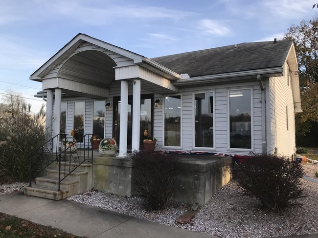

This Property Is For Sale
Property Detail
904 E Pulaski Hwy
03-026647
.723 ACRE 904 EAST PULASKI HIGHWAY E OF ELKTON
Commercialofficeresidentialmixeduse
Cecil
BI
Maryland
B and X Area of moderate flood hazard, usually the area between the limits of the 100-year and 500-year floods.
0.72 AC
2025
Cecil County
2025
Baltimore
030505
Philadelphia-Camden-Wilmington, PA-NJ-DE-MD
2,204 SF
NEARBY LISTINGS FOR SALE OR LEASE
DEMOGRAPHICS near 904 E Pulaski Hwy
1 mile
3 mile
5 mile
2025 Total Population
6,627
32,663
75,869
2030 Population
6,671
33,375
77,666
Pop Growth 2025-2030
+ 0.66%
+ 2.18%
+ 2.37%
Average Age
39
39
40
2025 Total Households
2,468
11,981
28,569
HH Growth 2025-2030
+ 0.53%
+ 2.20%
+ 2.45%
Median Household Inc
$83,526
$86,153
$90,743
Avg Household Size
2.60
2.60
2.60
2025 Avg HH Vehicles
2.00
2.00
2.00
Median Home Value
$268,069
$351,183
$356,211
Median Year Built
1985
1991
1990
Nearby Places
Map Layers
Map Styles
 Street
 Aerial
Transit
 Traffic
 Biking
Places
Listings with unknown addresses are not visible on the map
- Restaurants
- Banks
- Shops
- Fitness
- Groceries
PUBLIC TRANSPORTATION
COMMUTER RAIL
Newark (R2 - Southeastern Pennsylvania Transportation Authority Regional Rail (SEPTA Regional Rail))
Drive
Walk
Distance
Newark (R2 - Southeastern Pennsylvania Transportation Authority Regional Rail (SEPTA Regional Rail))
11 min
7.6 mi
Freight Ports
Port of Wilmington, RI
Drive
Walk
Distance
Port of Wilmington, RI
28 min
19.5 mi
Nearby Properties
Address
Land Use
TOTAL SIZE
Lot Size
Zoning
Address
Land Use
TOTAL SIZE
Lot Size
Zoning
766,520 SF
69.52 AC
BI
Address
Land Use
TOTAL SIZE
Lot Size
Zoning
193,004 SF
3.67 AC
C1
Address
Land Use
TOTAL SIZE
Lot Size
Zoning
200,880 SF
49.83 AC
R3
Address
Land Use
TOTAL SIZE
Lot Size
Zoning
263,500 SF
15.28 AC
BI
Address
Land Use
TOTAL SIZE
Lot Size
Zoning
20,973 SF
75.14 AC
M1
Address
Land Use
TOTAL SIZE
Lot Size
Zoning
266,818 SF
64.16 AC
BP
Address
Land Use
TOTAL SIZE
Lot Size
Zoning
62,900 SF
30.54 AC
S
Address
Land Use
TOTAL SIZE
Lot Size
Zoning
41,000 SF
32.49 AC
M1
Address
Land Use
TOTAL SIZE
Lot Size
Zoning
82,688 SF
11.30 AC
BI
Address
Land Use
TOTAL SIZE
Lot Size
Zoning
65,668 SF
4.52 AC
C2
Address
Land Use
TOTAL SIZE
Lot Size
Zoning
267,840 SF
20.35 AC
BI
Address
Land Use
TOTAL SIZE
Lot Size
Zoning
161,018 SF
97.88 AC
OR
Address
Land Use
TOTAL SIZE
Lot Size
Zoning
226,878 SF
73.68 AC
CR
Address
Land Use
TOTAL SIZE
Lot Size
Zoning
131,806 SF
21.97 AC
BI
Address
Land Use
TOTAL SIZE
Lot Size
Zoning
31,350 SF
8.89 AC
R2
Address
Land Use
TOTAL SIZE
Lot Size
Zoning
205,955 SF
24.91 AC
BI
Address
Land Use
TOTAL SIZE
Lot Size
Zoning
17.50 AC
R3
Address
Land Use
TOTAL SIZE
Lot Size
Zoning
2,189 SF
37.37 AC
BI
Address
Land Use
TOTAL SIZE
Lot Size
Zoning
85,924 SF
2.95 AC
C1
Address
Land Use
TOTAL SIZE
Lot Size
Zoning
159,038 SF
22.52 AC
R3
Address
Land Use
TOTAL SIZE
Lot Size
Zoning
56,815 SF
2.40 AC
C1
Address
Land Use
TOTAL SIZE
Lot Size
Zoning
64,800 SF
14.01 AC
C3
Address
Land Use
TOTAL SIZE
Lot Size
Zoning
32,997 SF
6.77 AC
R3 C2
Address
Land Use
TOTAL SIZE
Lot Size
Zoning
277,806 SF
31.82 AC
C2
Address
Land Use
TOTAL SIZE
Lot Size
Zoning
11,200 SF
64.19 AC
BI
Address
Land Use
TOTAL SIZE
Lot Size
Zoning
8,000 SF
11.51 AC
C2
Address
Land Use
TOTAL SIZE
Lot Size
Zoning
65,332 SF
10.56 AC
R3 RP
Address
Land Use
TOTAL SIZE
Lot Size
Zoning
35,617 SF
4.15 AC
C2
Address
Land Use
TOTAL SIZE
Lot Size
Zoning
82,079 SF
13.60 AC
R2
Address
Land Use
TOTAL SIZE
Lot Size
Zoning
62,609 SF
15 AC
R2
The World's #1 Commercial Real Estate Marketplace
Connect with us
© 2026 CoStar Group
The information above has been obtained from sources believed reliable. While we do not doubt its accuracy we have not verified it and make no guarantee, warranty or representation about it. It is your responsibility to independently confirm its accuracy and completeness. Any projections, opinions, assumptions, or estimates used are for example only and do not represent the current or future performance of the property. The value of this transaction to you depends on tax and other factors which should be evaluated by your tax, financial, and legal advisors. You and your advisors should conduct a careful, independent investigation of the property to determine to your satisfaction the suitability of the property for your needs.