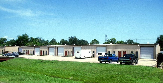
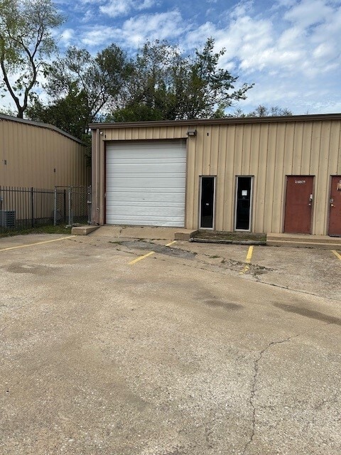
Property Record
9050 Emnora Ln, Houston, TX 77080

Current Lease Availabilities
NEARBY LISTINGS FOR SALE OR LEASE
Property Detail
9050 Emnora Ln
0681440010009
Spring Branch Estates Sec 2
Warehouse
TRS B4 & B5 BLK 1 SPRING BRANCH ESTATES SEC 2
X
Harris
48201C0635M
Texas
2024
0.72 AC
2025
Northwest Inner Loop
521300
Houston
13,320 SF
Houston-The Woodlands-Sugar Land, TX
DEMOGRAPHICS near 9050 Emnora Ln
1 Mile
3 Mile
5 Mile
2024 Total Population
23,623
144,293
315,759
2029 Population
24,433
148,419
324,726
Pop Growth 2024-2029
+ 3.43%
+ 2.86%
+ 2.84%
Average Age
36
37
38
2024 Total Households
8,315
52,798
122,388
HH Growth 2024-2029
+ 3.56%
+ 2.94%
+ 2.92%
Median Household Inc
$54,977
$56,261
$66,657
Avg Household Size
2.70
2.60
2.50
2024 Avg HH Vehicles
2.00
2.00
2.00
Median Home Value
$304,833
$319,231
$370,985
Median Year Built
1976
1976
1978
Nearby Places
Map Layers
Map Styles
 Street
 Aerial
- Restaurants
- Banks
- Shops
- Fitness
- Groceries
PUBLIC TRANSPORTATION
AIRPORT
George Bush Intcntl/Houston
DRIVE
WALK
Distance
George Bush Intcntl/Houston
34 min
23.0 mi
William P Hobby
DRIVE
WALK
Distance
William P Hobby
40 min
24.8 mi
Freight Ports
Port of Houston
DRIVE
WALK
Distance
Port of Houston
33 min
21.6 mi
Nearby Properties
Address
Land Use
TOTAL SIZE
Lot Size
Zoning
Address
Land Use
TOTAL SIZE
Lot Size
Zoning
935,613 SF
27.93 AC
Address
Land Use
TOTAL SIZE
Lot Size
Zoning
797,516 SF
2.91 AC
Address
Land Use
TOTAL SIZE
Lot Size
Zoning
797,509 SF
3.11 AC
Address
Land Use
TOTAL SIZE
Lot Size
Zoning
730,107 SF
2.92 AC
Address
Land Use
TOTAL SIZE
Lot Size
Zoning
730,107 SF
2.57 AC
Address
Land Use
TOTAL SIZE
Lot Size
Zoning
542,880 SF
1.22 AC
Address
Land Use
TOTAL SIZE
Lot Size
Zoning
743,954 SF
2.97 AC
Address
Land Use
TOTAL SIZE
Lot Size
Zoning
487,073 SF
44.12 AC
Address
Land Use
TOTAL SIZE
Lot Size
Zoning
507,014 SF
2.93 AC
Address
Land Use
TOTAL SIZE
Lot Size
Zoning
357,280 SF
1.72 AC
Address
Land Use
TOTAL SIZE
Lot Size
Zoning
497,932 SF
3.97 AC
Address
Land Use
TOTAL SIZE
Lot Size
Zoning
656,741 SF
1.88 AC
Address
Land Use
TOTAL SIZE
Lot Size
Zoning
224,114 SF
4.24 AC
Address
Land Use
TOTAL SIZE
Lot Size
Zoning
793,669 SF
121.83 AC
Address
Land Use
TOTAL SIZE
Lot Size
Zoning
504,256 SF
6.09 AC
Address
Land Use
TOTAL SIZE
Lot Size
Zoning
199,423 SF
Address
Land Use
TOTAL SIZE
Lot Size
Zoning
726,444 SF
7.29 AC
Address
Land Use
TOTAL SIZE
Lot Size
Zoning
324,600 SF
2.06 AC
Address
Land Use
TOTAL SIZE
Lot Size
Zoning
350,655 SF
16.76 AC
Address
Land Use
TOTAL SIZE
Lot Size
Zoning
475,272 SF
4.73 AC
Address
Land Use
TOTAL SIZE
Lot Size
Zoning
643,804 SF
31.40 AC
Address
Land Use
TOTAL SIZE
Lot Size
Zoning
342,163 SF
8.50 AC
Address
Land Use
TOTAL SIZE
Lot Size
Zoning
427,921 SF
18.14 AC
Address
Land Use
TOTAL SIZE
Lot Size
Zoning
251,980 SF
2.55 AC
Address
Land Use
TOTAL SIZE
Lot Size
Zoning
151,313 SF
1.21 AC
Address
Land Use
TOTAL SIZE
Lot Size
Zoning
153,000 SF
1.36 AC
Address
Land Use
TOTAL SIZE
Lot Size
Zoning
293,407 SF
9.19 AC
Address
Land Use
TOTAL SIZE
Lot Size
Zoning
386,682 SF
2.11 AC
Address
Land Use
TOTAL SIZE
Lot Size
Zoning
802,913 SF
27.11 AC
Address
Land Use
TOTAL SIZE
Lot Size
Zoning
281,843 SF
13.97 AC
The World's #1 Commercial Real Estate Marketplace
Connect with us
© 2025 CoStar Group
The information above has been obtained from sources believed reliable. While we do not doubt its accuracy we have not verified it and make no guarantee, warranty or representation about it. It is your responsibility to independently confirm its accuracy and completeness. Any projections, opinions, assumptions, or estimates used are for example only and do not represent the current or future performance of the property. The value of this transaction to you depends on tax and other factors which should be evaluated by your tax, financial, and legal advisors. You and your advisors should conduct a careful, independent investigation of the property to determine to your satisfaction the suitability of the property for your needs.