Property Record
9058 Rose St, Bellflower, CA 90706


Save to a Folder
{{folder.Name}}
{{folder.ListingIds.length}} Properties
{{folder.ListingIds.length}} Property
Create a New Folder
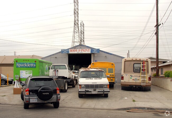
Property Detail
9058 Rose St
Los Angeles-Long Beach-Glendale, CA
CALIFORNIA CO-OPERATIVE COLONY TRACT LOT COM S 89 4726 W 705 FT FROM SE COR OF LOT 6 BLK 30 TH S 89 4726 W 53 FT TH N 0 1610 W 200.6 FT TH N 89 4220 E 53 FT TH S 0 1610 E TO BEG PART OF LOT 6 BLK 30
7162-004-005
Los Angeles
Foodprocessing
California
BFM1*
6
2025
0.24 AC
2025
Cerritos/Norwalk
554403
Los Angeles
5,040 SF
NEARBY LISTINGS FOR SALE OR LEASE
DEMOGRAPHICS near 9058 Rose St
1 mile
3 mile
5 mile
2025 Total Population
35,508
269,683
656,401
2030 Population
34,897
266,352
647,312
Pop Growth 2025-2030
(1.72%)
(1.24%)
(1.38%)
Average Age
39
39
39
2025 Total Households
10,667
82,861
194,486
HH Growth 2025-2030
(2.01%)
(1.49%)
(1.61%)
Median Household Inc
$88,747
$88,662
$91,607
Avg Household Size
3.10
3.10
3.20
2025 Avg HH Vehicles
2.00
2.00
2.00
Median Home Value
$701,087
$726,227
$736,307
Median Year Built
1960
1959
1958
Nearby Places
Map Layers
Map Styles
 Street
 Aerial
Layers
 Traffic
 Biking
Places
Listings with unknown addresses are not visible on the map
- Restaurants
- Banks
- Shops
- Fitness
- Groceries
PUBLIC TRANSPORTATION
COMMUTER RAIL
Norwalk/Santa Fe Springs (91 Line - Southern California Regional Rail Authority (Metrolink), Orange County Line - Southern California Regional Rail Authority (Metrolink))
Drive
Walk
Distance
Norwalk/Santa Fe Springs (91 Line - Southern California Regional Rail Authority (Metrolink), Orange County Line - Southern California Regional Rail Authority (Metrolink))
14 min
8.1 mi
AIRPORT
Long Beach (Daugherty Field)
Drive
Walk
Distance
Long Beach (Daugherty Field)
11 min
5.6 mi
Los Angeles International
Drive
Walk
Distance
Los Angeles International
29 min
20.3 mi
John Wayne/Orange County
Drive
Walk
Distance
John Wayne/Orange County
33 min
25.4 mi
SALE & LEASE HISTORY
LISTING DATE
SALE/LEASE

Jul 12, 2024
For Sale
Nearby Properties
Address
Land Use
TOTAL SIZE
Lot Size
Zoning
Address
Land Use
TOTAL SIZE
Lot Size
Zoning
324,400 SF
55.03 AC
CECR
Address
Land Use
TOTAL SIZE
Lot Size
Zoning
202,924 SF
99.50 AC
LKC4*
Address
Land Use
TOTAL SIZE
Lot Size
Zoning
556,348 SF
26.38 AC
PAM2
Address
Land Use
TOTAL SIZE
Lot Size
Zoning
730,731 SF
14.89 AC
BFCG*
Address
Land Use
TOTAL SIZE
Lot Size
Zoning
353,001 SF
4.81 AC
CEM
Address
Land Use
TOTAL SIZE
Lot Size
Zoning
373,498 SF
5.20 AC
LBR4R
Address
Land Use
TOTAL SIZE
Lot Size
Zoning
395,436 SF
17.22 AC
LBMG
Address
Land Use
TOTAL SIZE
Lot Size
Zoning
160,112 SF
3.94 AC
LBPPD1
Address
Land Use
TOTAL SIZE
Lot Size
Zoning
108,931 SF
5.76 AC
LBPPD1
Address
Land Use
TOTAL SIZE
Lot Size
Zoning
97,250 SF
4.86 AC
LBPPD1
Address
Land Use
TOTAL SIZE
Lot Size
Zoning
1,097,606 SF
52.50 AC
LBPD
Address
Land Use
TOTAL SIZE
Lot Size
Zoning
247,536 SF
5.79 AC
CECR
Address
Land Use
TOTAL SIZE
Lot Size
Zoning
91,545 SF
2.86 AC
LBPPD1
Address
Land Use
TOTAL SIZE
Lot Size
Zoning
292,696 SF
11.48 AC
LBR4
Address
Land Use
TOTAL SIZE
Lot Size
Zoning
132,404 SF
4.84 AC
LBIG
Address
Land Use
TOTAL SIZE
Lot Size
Zoning
233,030 SF
10.95 AC
LBR4
Address
Land Use
TOTAL SIZE
Lot Size
Zoning
108,564 SF
2.48 AC
LBR4N
Address
Land Use
TOTAL SIZE
Lot Size
Zoning
80,114 SF
1.27 AC
LKC4*
Address
Land Use
TOTAL SIZE
Lot Size
Zoning
299,406 SF
1.72 AC
LKC4*
Address
Land Use
TOTAL SIZE
Lot Size
Zoning
76,570 SF
6.46 AC
LBPPD1
Address
Land Use
TOTAL SIZE
Lot Size
Zoning
1,004,620 SF
19.73 AC
CECR
Address
Land Use
TOTAL SIZE
Lot Size
Zoning
132,019 SF
5.22 AC
LKMFR*
Address
Land Use
TOTAL SIZE
Lot Size
Zoning
96,849 SF
7.56 AC
LKC3YY
Address
Land Use
TOTAL SIZE
Lot Size
Zoning
183,128 SF
10.77 AC
PAM2*
Address
Land Use
TOTAL SIZE
Lot Size
Zoning
193,300 SF
4.22 AC
CECR
Address
Land Use
TOTAL SIZE
Lot Size
Zoning
131,914 SF
10.15 AC
CECR
Address
Land Use
TOTAL SIZE
Lot Size
Zoning
160,769 SF
5.90 AC
LKC4*
Address
Land Use
TOTAL SIZE
Lot Size
Zoning
157,755 SF
9.90 AC
LBIG
The World's #1 Commercial Real Estate Marketplace
Connect with us
© 2026 CoStar Group
The information above has been obtained from sources believed reliable. While we do not doubt its accuracy we have not verified it and make no guarantee, warranty or representation about it. It is your responsibility to independently confirm its accuracy and completeness. Any projections, opinions, assumptions, or estimates used are for example only and do not represent the current or future performance of the property. The value of this transaction to you depends on tax and other factors which should be evaluated by your tax, financial, and legal advisors. You and your advisors should conduct a careful, independent investigation of the property to determine to your satisfaction the suitability of the property for your needs.