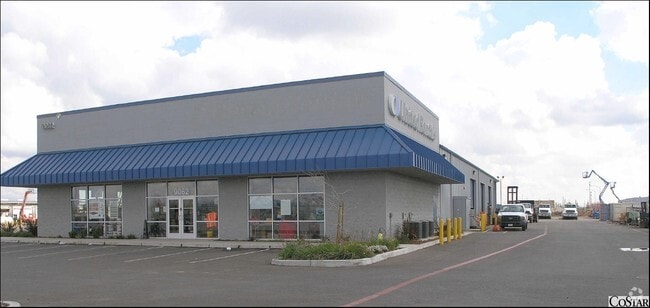
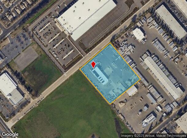
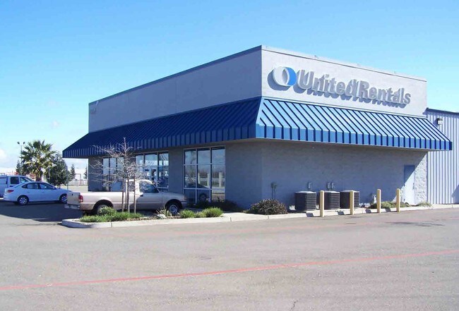
Property Record
9062 Union Park Way, Elk Grove, CA 95624

NEARBY LISTINGS FOR SALE OR LEASE
Property Detail
9062 Union Park Way
Sacramento--Roseville--Arden-Arcade, CA
Natomas Central
134-0620-029
PCL 4 & POR OF PCL 5, PM 92-14, DES AS BEG ATSW COR OF SD LOT 4 TH FR SD POB N40D4917W 483.51FT., TH N49D1043E 399.82FT.,
Vehiclerentalsvehiclesales
Sacramento
X
California
06067C0338H
4
2024
4.27 AC
2025
Elk Grove/Laguna
009310
Sacramento
12,950 SF
DEMOGRAPHICS near 9062 Union Park Way
1 Mile
3 Mile
5 Mile
2024 Total Population
6,330
58,094
153,834
2029 Population
6,591
59,180
155,243
Pop Growth 2024-2029
+ 4.12%
+ 1.87%
+ 0.92%
Average Age
37
39
39
2024 Total Households
1,954
18,274
46,783
HH Growth 2024-2029
+ 3.84%
+ 1.81%
+ 0.88%
Median Household Inc
$110,853
$110,859
$107,998
Avg Household Size
3.20
3.10
3.20
2024 Avg HH Vehicles
2.00
2.00
2.00
Median Home Value
$509,479
$600,383
$563,384
Median Year Built
1995
2000
2000
Nearby Places
Map Layers
Map Styles
 Street
 Aerial
- Restaurants
- Banks
- Shops
- Fitness
- Groceries
PUBLIC TRANSPORTATION
AIRPORT
Sacramento International
DRIVE
WALK
Distance
Sacramento International
40 min
29.2 mi
Freight Ports
Port of Stockton
DRIVE
WALK
Distance
Port of Stockton
47 min
36.9 mi
SALE & LEASE HISTORY
LISTING DATE
SALE/LEASE

Sep 24, 2016
For Sale
Nearby Properties
Address
Land Use
TOTAL SIZE
Lot Size
Zoning
Address
Land Use
TOTAL SIZE
Lot Size
Zoning
43.54 AC
LI
Address
Land Use
TOTAL SIZE
Lot Size
Zoning
7.65 AC
RD-20
Address
Land Use
TOTAL SIZE
Lot Size
Zoning
43.06 AC
LRSPA
Address
Land Use
TOTAL SIZE
Lot Size
Zoning
221,556 SF
20.10 AC
HI
Address
Land Use
TOTAL SIZE
Lot Size
Zoning
152,217 SF
17.42 AC
SC
Address
Land Use
TOTAL SIZE
Lot Size
Zoning
9.02 AC
SPASEPA
Address
Land Use
TOTAL SIZE
Lot Size
Zoning
64,579 SF
5.41 AC
LRSPA
Address
Land Use
TOTAL SIZE
Lot Size
Zoning
242,577 SF
0.10 AC
RD-20
Address
Land Use
TOTAL SIZE
Lot Size
Zoning
105,511 SF
4.79 AC
BP
Address
Land Use
TOTAL SIZE
Lot Size
Zoning
111,489 SF
4.96 AC
MP
Address
Land Use
TOTAL SIZE
Lot Size
Zoning
76,090 SF
3.32 AC
RD-25
Address
Land Use
TOTAL SIZE
Lot Size
Zoning
221,954 SF
7.71 AC
RD-15
Address
Land Use
TOTAL SIZE
Lot Size
Zoning
4.88 AC
RD-25
Address
Land Use
TOTAL SIZE
Lot Size
Zoning
102,526 SF
4.06 AC
MP
Address
Land Use
TOTAL SIZE
Lot Size
Zoning
100 SF
50.85 AC
LRSPA
Address
Land Use
TOTAL SIZE
Lot Size
Zoning
68,190 SF
3.75 AC
BP
Address
Land Use
TOTAL SIZE
Lot Size
Zoning
68,217 SF
8.95 AC
RD-20
Address
Land Use
TOTAL SIZE
Lot Size
Zoning
7.10 AC
GC
Address
Land Use
TOTAL SIZE
Lot Size
Zoning
5.38 AC
SC
Address
Land Use
TOTAL SIZE
Lot Size
Zoning
148,119 SF
11.23 AC
SC
Address
Land Use
TOTAL SIZE
Lot Size
Zoning
63,550 SF
5.53 AC
AC
Address
Land Use
TOTAL SIZE
Lot Size
Zoning
21.18 AC
HI
Address
Land Use
TOTAL SIZE
Lot Size
Zoning
53,949 SF
5.33 AC
AC
Address
Land Use
TOTAL SIZE
Lot Size
Zoning
15.50 AC
LRSPA
Address
Land Use
TOTAL SIZE
Lot Size
Zoning
1.99 AC
GC
Address
Land Use
TOTAL SIZE
Lot Size
Zoning
14.46 AC
LRSPA
Address
Land Use
TOTAL SIZE
Lot Size
Zoning
13.28 AC
LRSPA
Address
Land Use
TOTAL SIZE
Lot Size
Zoning
125,640 SF
10.25 AC
SC
Address
Land Use
TOTAL SIZE
Lot Size
Zoning
150,210 SF
6.25 AC
LI
Address
Land Use
TOTAL SIZE
Lot Size
Zoning
94,365 SF
6.49 AC
RD-20
The World's #1 Commercial Real Estate Marketplace
Connect with us
© 2025 CoStar Group
The information above has been obtained from sources believed reliable. While we do not doubt its accuracy we have not verified it and make no guarantee, warranty or representation about it. It is your responsibility to independently confirm its accuracy and completeness. Any projections, opinions, assumptions, or estimates used are for example only and do not represent the current or future performance of the property. The value of this transaction to you depends on tax and other factors which should be evaluated by your tax, financial, and legal advisors. You and your advisors should conduct a careful, independent investigation of the property to determine to your satisfaction the suitability of the property for your needs.