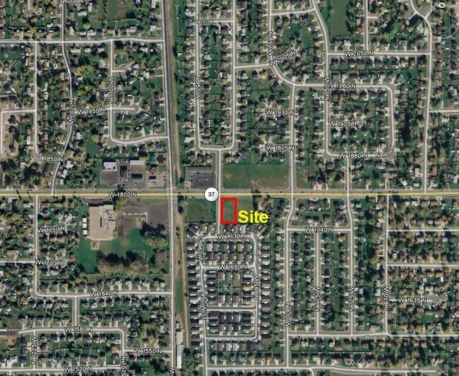
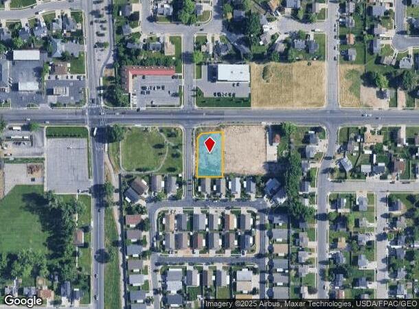
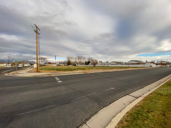
Property Record
909 W 1800 N, Clinton, UT 84015
NEARBY LISTINGS FOR SALE OR LEASE
Property Detail
909 W 1800 N
13-078-0059
BEG AT A PT ON THE S LINE OF 1800 NORTH STR WH IS S 89^56'08" E 527.00 FT ALG THE 1/4 SEC LINE & S 00^03'52" W 42.00 FT FR THE W 1/4 COR OF SEC 26-T5N-R2W, SLM; & RUN TH S 00^03'52" W 211.00 FT TO THE
Miscellaneous
Davis
X
Utah
49057C0425F
0.52 AC
2025
Davis/Weber Counties
2025
Salt Lake City
125502
Ogden-Clearfield, UT
DEMOGRAPHICS near 909 W 1800 N
1 Mile
3 Mile
5 Mile
2024 Total Population
15,905
93,056
213,759
2029 Population
16,612
99,072
228,594
Pop Growth 2024-2029
+ 4.45%
+ 6.46%
+ 6.94%
Average Age
35
34
34
2024 Total Households
4,972
29,164
67,522
HH Growth 2024-2029
+ 4.53%
+ 6.66%
+ 7.09%
Median Household Inc
$77,886
$79,613
$81,302
Avg Household Size
3.20
3.10
3.10
2024 Avg HH Vehicles
2.00
2.00
2.00
Median Home Value
$344,956
$352,485
$370,469
Median Year Built
1983
1989
1994
Nearby Places
Map Layers
Map Styles
 Street
 Aerial
- Restaurants
- Banks
- Shops
- Fitness
- Groceries
PUBLIC TRANSPORTATION
COMMUTER RAIL
Clearfield (FrontRunner North - Utah Transit Authority (UTA))
DRIVE
WALK
Distance
Clearfield (FrontRunner North - Utah Transit Authority (UTA))
9 min
4.5 mi
Roy (FrontRunner North - Utah Transit Authority (UTA))
DRIVE
WALK
Distance
Roy (FrontRunner North - Utah Transit Authority (UTA))
11 min
5.2 mi
AIRPORT
Salt Lake City International
DRIVE
WALK
Distance
Salt Lake City International
41 min
33.2 mi
SALE & LEASE HISTORY
LISTING DATE
SALE/LEASE

Nov 17, 2020
For Lease
Jan 27, 2017
For Sale
Nearby Properties
Address
Land Use
TOTAL SIZE
Lot Size
Zoning
Address
Land Use
TOTAL SIZE
Lot Size
Zoning
399,630 SF
31.55 AC
I
Address
Land Use
TOTAL SIZE
Lot Size
Zoning
664,440 SF
37.07 AC
Address
Land Use
TOTAL SIZE
Lot Size
Zoning
151,064 SF
48.81 AC
Address
Land Use
TOTAL SIZE
Lot Size
Zoning
123,824 SF
41.89 AC
M1
Address
Land Use
TOTAL SIZE
Lot Size
Zoning
125,164 SF
7.12 AC
Address
Land Use
TOTAL SIZE
Lot Size
Zoning
7,492 SF
8.96 AC
Address
Land Use
TOTAL SIZE
Lot Size
Zoning
121,332 SF
44.40 AC
Address
Land Use
TOTAL SIZE
Lot Size
Zoning
91,750 SF
6.76 AC
C2
Address
Land Use
TOTAL SIZE
Lot Size
Zoning
63,828 SF
5.30 AC
PF
Address
Land Use
TOTAL SIZE
Lot Size
Zoning
76,778 SF
5.51 AC
Address
Land Use
TOTAL SIZE
Lot Size
Zoning
5,481 SF
15.54 AC
Address
Land Use
TOTAL SIZE
Lot Size
Zoning
74,995 SF
6.07 AC
Address
Land Use
TOTAL SIZE
Lot Size
Zoning
223,079 SF
22.55 AC
Address
Land Use
TOTAL SIZE
Lot Size
Zoning
503,599 SF
47.71 AC
M1
Address
Land Use
TOTAL SIZE
Lot Size
Zoning
57,165 SF
8.50 AC
GC
Address
Land Use
TOTAL SIZE
Lot Size
Zoning
147,184 SF
2.53 AC
Address
Land Use
TOTAL SIZE
Lot Size
Zoning
293,860 SF
20.61 AC
M1
Address
Land Use
TOTAL SIZE
Lot Size
Zoning
11,877 SF
5.44 AC
CC
Address
Land Use
TOTAL SIZE
Lot Size
Zoning
121,173 SF
11.74 AC
CC
Address
Land Use
TOTAL SIZE
Lot Size
Zoning
69,331 SF
7.46 AC
R2
Address
Land Use
TOTAL SIZE
Lot Size
Zoning
62,246 SF
5.37 AC
PZ
Address
Land Use
TOTAL SIZE
Lot Size
Zoning
21,980 SF
11.68 AC
Address
Land Use
TOTAL SIZE
Lot Size
Zoning
140,015 SF
12.14 AC
PZ
Address
Land Use
TOTAL SIZE
Lot Size
Zoning
121,026 SF
4.78 AC
Address
Land Use
TOTAL SIZE
Lot Size
Zoning
88,125 SF
7.17 AC
PZ
Address
Land Use
TOTAL SIZE
Lot Size
Zoning
58,287 SF
5.18 AC
Address
Land Use
TOTAL SIZE
Lot Size
Zoning
50,440 SF
5.26 AC
The World's #1 Commercial Real Estate Marketplace
Connect with us
© 2025 CoStar Group
The information above has been obtained from sources believed reliable. While we do not doubt its accuracy we have not verified it and make no guarantee, warranty or representation about it. It is your responsibility to independently confirm its accuracy and completeness. Any projections, opinions, assumptions, or estimates used are for example only and do not represent the current or future performance of the property. The value of this transaction to you depends on tax and other factors which should be evaluated by your tax, financial, and legal advisors. You and your advisors should conduct a careful, independent investigation of the property to determine to your satisfaction the suitability of the property for your needs.