Property Record
910 Carlow Dr, Bolingbrook, IL 60490
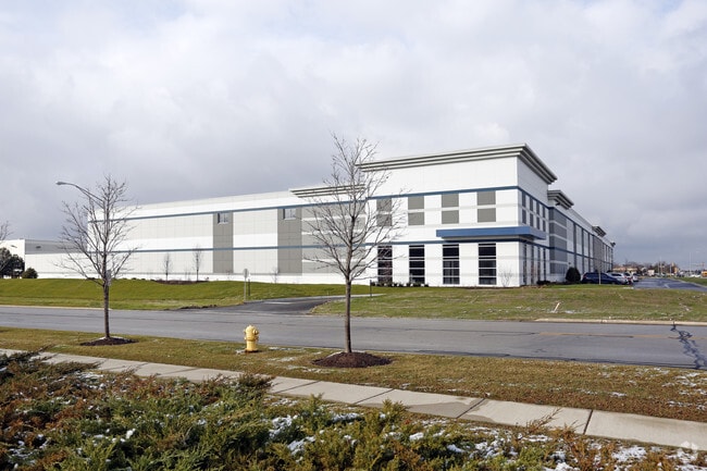


Property Detail
910 Carlow Dr
Chicago-Naperville-Elgin, IL-IN
LOT 2 IN CARLOW CORPORATE CENTER NORTH UNIT 6, A RESUB OF LOT 1 IN CARLOW CORPORATE CENTER NORTH UNIT 4, BEING A SUB OF PRT O
12-02-30-202-011
WILL
Industrialgeneral
Illinois
A Areas with a 1% annual chance of flooding and a 26% chance of flooding over the life of a 30-year mortgage.
2
2025
7.29 AC
2024
South I-55 Corridor
880125
Chicago
113,472 SF
NEARBY LISTINGS FOR SALE OR LEASE
DEMOGRAPHICS near 910 Carlow Dr
1 mile
3 mile
5 mile
2025 Total Population
4,064
67,896
178,139
2030 Population
4,092
68,629
179,820
Pop Growth 2025-2030
+ 0.69%
+ 1.08%
+ 0.94%
Average Age
37
40
39
2025 Total Households
1,183
22,347
58,248
HH Growth 2025-2030
+ 0.85%
+ 1.19%
+ 1.06%
Median Household Inc
$146,513
$104,894
$118,037
Avg Household Size
3.40
3.00
3.00
2025 Avg HH Vehicles
2.00
2.00
2.00
Median Home Value
$369,785
$308,697
$344,854
Median Year Built
2001
1994
1993
Nearby Places
Map Layers
Map Styles
 Street
 Aerial
Layers
 Traffic
 Biking
Places
Listings with unknown addresses are not visible on the map
- Restaurants
- Banks
- Shops
- Fitness
- Groceries
PUBLIC TRANSPORTATION
COMMUTER RAIL
Romeoville (Heritage Corridor - Metra)
Drive
Walk
Distance
Romeoville (Heritage Corridor - Metra)
14 min
6.0 mi
AIRPORT
Chicago Midway International
Drive
Walk
Distance
Chicago Midway International
32 min
23.3 mi
Chicago O'Hare International
Drive
Walk
Distance
Chicago O'Hare International
49 min
34.8 mi
Freight Ports
Port Milwaukee
Drive
Walk
Distance
Port Milwaukee
131 min
106.5 mi
Nearby Properties
Address
Land Use
TOTAL SIZE
Lot Size
Zoning
Address
Land Use
TOTAL SIZE
Lot Size
Zoning
49.82 AC
Address
Land Use
TOTAL SIZE
Lot Size
Zoning
1,107,073 SF
35.03 AC
Address
Land Use
TOTAL SIZE
Lot Size
Zoning
Address
Land Use
TOTAL SIZE
Lot Size
Zoning
747,420 SF
49.43 AC
Address
Land Use
TOTAL SIZE
Lot Size
Zoning
62.35 AC
Address
Land Use
TOTAL SIZE
Lot Size
Zoning
13.71 AC
Address
Land Use
TOTAL SIZE
Lot Size
Zoning
37.47 AC
Address
Land Use
TOTAL SIZE
Lot Size
Zoning
28.82 AC
Address
Land Use
TOTAL SIZE
Lot Size
Zoning
766,789 SF
52.04 AC
Address
Land Use
TOTAL SIZE
Lot Size
Zoning
751,809 SF
36.59 AC
Address
Land Use
TOTAL SIZE
Lot Size
Zoning
806,164 SF
35.45 AC
Address
Land Use
TOTAL SIZE
Lot Size
Zoning
800,000 SF
43.13 AC
Address
Land Use
TOTAL SIZE
Lot Size
Zoning
715,638 SF
35.12 AC
Address
Land Use
TOTAL SIZE
Lot Size
Zoning
172,838 SF
14.76 AC
Address
Land Use
TOTAL SIZE
Lot Size
Zoning
Address
Land Use
TOTAL SIZE
Lot Size
Zoning
698,727 SF
40.97 AC
Address
Land Use
TOTAL SIZE
Lot Size
Zoning
723,073 SF
37.46 AC
Address
Land Use
TOTAL SIZE
Lot Size
Zoning
652,056 SF
26.43 AC
Address
Land Use
TOTAL SIZE
Lot Size
Zoning
691,629 SF
32.73 AC
Address
Land Use
TOTAL SIZE
Lot Size
Zoning
615,239 SF
33.44 AC
Address
Land Use
TOTAL SIZE
Lot Size
Zoning
660,649 SF
29.66 AC
Address
Land Use
TOTAL SIZE
Lot Size
Zoning
23.85 AC
Address
Land Use
TOTAL SIZE
Lot Size
Zoning
649,933 SF
31.18 AC
Address
Land Use
TOTAL SIZE
Lot Size
Zoning
Address
Land Use
TOTAL SIZE
Lot Size
Zoning
604,084 SF
32.65 AC
Address
Land Use
TOTAL SIZE
Lot Size
Zoning
602,328 SF
30.50 AC
Address
Land Use
TOTAL SIZE
Lot Size
Zoning
965,899 SF
22.17 AC
Address
Land Use
TOTAL SIZE
Lot Size
Zoning
12.52 AC
Address
Land Use
TOTAL SIZE
Lot Size
Zoning
33.74 AC
Address
Land Use
TOTAL SIZE
Lot Size
Zoning
12.84 AC
The World's #1 Commercial Real Estate Marketplace
Connect with us
© 2026 CoStar Group
The information above has been obtained from sources believed reliable. While we do not doubt its accuracy we have not verified it and make no guarantee, warranty or representation about it. It is your responsibility to independently confirm its accuracy and completeness. Any projections, opinions, assumptions, or estimates used are for example only and do not represent the current or future performance of the property. The value of this transaction to you depends on tax and other factors which should be evaluated by your tax, financial, and legal advisors. You and your advisors should conduct a careful, independent investigation of the property to determine to your satisfaction the suitability of the property for your needs.