Property Record
9234 W Loop 1604 N, San Antonio, TX 78254
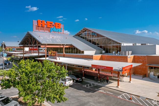

Property Detail
9234 W Loop 1604 N
San Antonio-New Braunfels, TX
NCB 14614 (SA #32 BANDERA SUBD), BLOCK 11 LOT IRR PART OF 7 2024-MAP/LEGAL UPDATE PER PLAT 20003/637-6432013- NEW PER PLAT 9636/152-159 FILED 1-13-2012
14614-011-0070
BEXAR
Departmentstore
Texas
AE The base floodplain where base flood elevations are provided. AE Zones are now used on new format FIRMs instead of A1-A30 Zones.
7
2024
37.26 AC
2025
Northwest
181726
San Antonio
237,499 SF
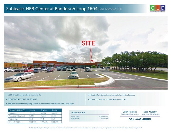
NEARBY LISTINGS FOR SALE OR LEASE
DEMOGRAPHICS near 9234 W Loop 1604 N
1 mile
3 mile
5 mile
2025 Total Population
10,835
98,645
247,588
2030 Population
11,073
102,470
259,176
Pop Growth 2025-2030
+ 2.20%
+ 3.88%
+ 4.68%
Average Age
38
37
37
2025 Total Households
3,969
34,906
91,521
HH Growth 2025-2030
+ 1.97%
+ 3.94%
+ 4.90%
Median Household Inc
$101,234
$99,626
$85,834
Avg Household Size
2.70
2.80
2.60
2025 Avg HH Vehicles
2.00
2.00
2.00
Median Home Value
$322,815
$309,354
$293,311
Median Year Built
2002
1997
1997
Nearby Places
Map Layers
Map Styles
 Street
 Aerial
Layers
 Traffic
 Biking
Places
Listings with unknown addresses are not visible on the map
- Restaurants
- Banks
- Shops
- Fitness
- Groceries
PUBLIC TRANSPORTATION
AIRPORT
San Antonio International
Drive
Walk
Distance
San Antonio International
18 min
17.1 mi
Freight Ports
Calhoun Port
Drive
Walk
Distance
Calhoun Port
1 min
140.9 mi
SALE & LEASE HISTORY
LISTING DATE
SALE/LEASE

Sep 25, 2016
For Lease
Apr 11, 2018
For Lease
Nearby Properties
Address
Land Use
TOTAL SIZE
Lot Size
Zoning
Address
Land Use
TOTAL SIZE
Lot Size
Zoning
520,686 SF
53.63 AC
Address
Land Use
TOTAL SIZE
Lot Size
Zoning
413,362 SF
33.77 AC
Address
Land Use
TOTAL SIZE
Lot Size
Zoning
149,500 SF
9.36 AC
Address
Land Use
TOTAL SIZE
Lot Size
Zoning
305,600 SF
30.64 AC
Address
Land Use
TOTAL SIZE
Lot Size
Zoning
284,890 SF
18.83 AC
Address
Land Use
TOTAL SIZE
Lot Size
Zoning
307,272 SF
24.14 AC
Address
Land Use
TOTAL SIZE
Lot Size
Zoning
331,020 SF
20.13 AC
Address
Land Use
TOTAL SIZE
Lot Size
Zoning
220,719 SF
25.86 AC
Address
Land Use
TOTAL SIZE
Lot Size
Zoning
289,158 SF
31.78 AC
Address
Land Use
TOTAL SIZE
Lot Size
Zoning
217,267 SF
17.63 AC
Address
Land Use
TOTAL SIZE
Lot Size
Zoning
229,430 SF
11.92 AC
Address
Land Use
TOTAL SIZE
Lot Size
Zoning
255,890 SF
14.23 AC
Address
Land Use
TOTAL SIZE
Lot Size
Zoning
232,610 SF
13.16 AC
Address
Land Use
TOTAL SIZE
Lot Size
Zoning
230,048 SF
10.70 AC
Address
Land Use
TOTAL SIZE
Lot Size
Zoning
185,896 SF
26.12 AC
Address
Land Use
TOTAL SIZE
Lot Size
Zoning
458,331 SF
4.99 AC
Address
Land Use
TOTAL SIZE
Lot Size
Zoning
1,080 SF
92.05 AC
Address
Land Use
TOTAL SIZE
Lot Size
Zoning
193,004 SF
16.43 AC
Address
Land Use
TOTAL SIZE
Lot Size
Zoning
228,364 SF
16.14 AC
Address
Land Use
TOTAL SIZE
Lot Size
Zoning
191,361 SF
15.02 AC
Address
Land Use
TOTAL SIZE
Lot Size
Zoning
246,381 SF
10.56 AC
Address
Land Use
TOTAL SIZE
Lot Size
Zoning
215,505 SF
11.21 AC
Address
Land Use
TOTAL SIZE
Lot Size
Zoning
194,289 SF
13.32 AC
Address
Land Use
TOTAL SIZE
Lot Size
Zoning
37,500 SF
3.58 AC
Address
Land Use
TOTAL SIZE
Lot Size
Zoning
248,352 SF
14.72 AC
Address
Land Use
TOTAL SIZE
Lot Size
Zoning
235,417 SF
12.64 AC
Address
Land Use
TOTAL SIZE
Lot Size
Zoning
74,514 SF
15.57 AC
Address
Land Use
TOTAL SIZE
Lot Size
Zoning
169,822 SF
7 AC
Address
Land Use
TOTAL SIZE
Lot Size
Zoning
253,680 SF
20.55 AC
The World's #1 Commercial Real Estate Marketplace
Connect with us
© 2026 CoStar Group
The information above has been obtained from sources believed reliable. While we do not doubt its accuracy we have not verified it and make no guarantee, warranty or representation about it. It is your responsibility to independently confirm its accuracy and completeness. Any projections, opinions, assumptions, or estimates used are for example only and do not represent the current or future performance of the property. The value of this transaction to you depends on tax and other factors which should be evaluated by your tax, financial, and legal advisors. You and your advisors should conduct a careful, independent investigation of the property to determine to your satisfaction the suitability of the property for your needs.