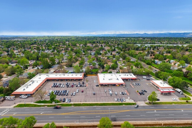
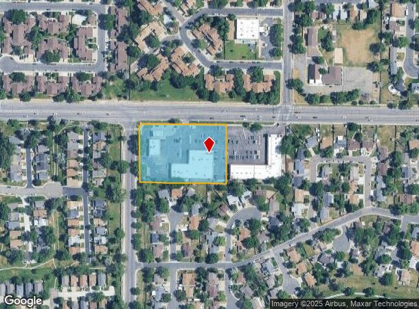
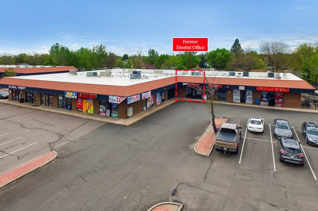
Property Record
9102 W 88Th Ave, Arvada, CO 80005
NEARBY LISTINGS FOR SALE OR LEASE
Property Detail
9102 W 88Th Ave
Denver-Aurora-Lakewood, CO
Trailside Commercial Subdivision
29-271-02-060
SECTION 27 TOWNSHIP 02 RANGE 69 QTR NE SUBDIVISIONCD 758500 SUBDIVISIONNAME TRAILSIDE COMMERCIAL SUBDIVISION BLOCK LOT 0001 SIZE: 98358 TRACT VALUE: 2.258
Commercialnec
Jefferson
X
Colorado
08059C0201G
1
2023
2.26 AC
2024
Northwest
009834
Denver
19,220 SF
DEMOGRAPHICS near 9102 W 88Th Ave
1 Mile
3 Mile
5 Mile
2024 Total Population
13,138
92,444
260,858
2029 Population
12,874
91,484
263,517
Pop Growth 2024-2029
(2.01%)
(1.04%)
+ 1.02%
Average Age
43
41
40
2024 Total Households
5,631
36,855
103,975
HH Growth 2024-2029
(2.10%)
(1.01%)
+ 1.09%
Median Household Inc
$95,120
$94,656
$85,910
Avg Household Size
2.30
2.40
2.40
2024 Avg HH Vehicles
2.00
2.00
2.00
Median Home Value
$434,299
$478,476
$467,307
Median Year Built
1977
1978
1980
Nearby Places
- Restaurants
- Banks
- Shops
- Fitness
- Groceries
PUBLIC TRANSPORTATION
COMMUTER RAIL
Olde Town Arvada E-Bound (Union Station to Wheat Ridge Ward Station - Regional Transportation District)
DRIVE
WALK
Distance
Olde Town Arvada E-Bound (Union Station to Wheat Ridge Ward Station - Regional Transportation District)
10 min
5.2 mi
Olde Town Arvada W-Bound (Union Station to Wheat Ridge Ward Station - Regional Transportation District)
DRIVE
WALK
Distance
Olde Town Arvada W-Bound (Union Station to Wheat Ridge Ward Station - Regional Transportation District)
11 min
5.6 mi
AIRPORT
Denver International
DRIVE
WALK
Distance
Denver International
41 min
30.5 mi
Freight Ports
Tulsa Port Of Catoosa
DRIVE
WALK
Distance
Tulsa Port Of Catoosa
738 min
716.0 mi
SALE & LEASE HISTORY
LISTING DATE
SALE/LEASE

Sep 22, 2023
For Lease
Jul 17, 2017
For Lease
Apr 21, 2017
For Lease
Nearby Properties
Address
Land Use
TOTAL SIZE
Lot Size
Zoning
Address
Land Use
TOTAL SIZE
Lot Size
Zoning
431,902 SF
17.63 AC
Address
Land Use
TOTAL SIZE
Lot Size
Zoning
211,191 SF
30.46 AC
Address
Land Use
TOTAL SIZE
Lot Size
Zoning
253,643 SF
50.87 AC
A2
Address
Land Use
TOTAL SIZE
Lot Size
Zoning
209,009 SF
22.30 AC
Address
Land Use
TOTAL SIZE
Lot Size
Zoning
53,602 SF
2.37 AC
Address
Land Use
TOTAL SIZE
Lot Size
Zoning
674,481 SF
21.06 AC
Address
Land Use
TOTAL SIZE
Lot Size
Zoning
250,701 SF
14.14 AC
Address
Land Use
TOTAL SIZE
Lot Size
Zoning
70,338 SF
2.57 AC
Address
Land Use
TOTAL SIZE
Lot Size
Zoning
121,639 SF
25.99 AC
Address
Land Use
TOTAL SIZE
Lot Size
Zoning
114,230 SF
2.88 AC
Address
Land Use
TOTAL SIZE
Lot Size
Zoning
310,000 SF
26.51 AC
Address
Land Use
TOTAL SIZE
Lot Size
Zoning
315,637 SF
8.56 AC
Address
Land Use
TOTAL SIZE
Lot Size
Zoning
155,081 SF
7.42 AC
Address
Land Use
TOTAL SIZE
Lot Size
Zoning
559,786 SF
26.52 AC
Address
Land Use
TOTAL SIZE
Lot Size
Zoning
115,054 SF
21.38 AC
Address
Land Use
TOTAL SIZE
Lot Size
Zoning
102,598 SF
7.52 AC
Address
Land Use
TOTAL SIZE
Lot Size
Zoning
269,040 SF
16.05 AC
Address
Land Use
TOTAL SIZE
Lot Size
Zoning
99,957 SF
13.26 AC
Address
Land Use
TOTAL SIZE
Lot Size
Zoning
115,723 SF
24.06 AC
Address
Land Use
TOTAL SIZE
Lot Size
Zoning
162,509 SF
11.84 AC
Address
Land Use
TOTAL SIZE
Lot Size
Zoning
149,115 SF
18 AC
Address
Land Use
TOTAL SIZE
Lot Size
Zoning
22,173 SF
6.02 AC
Address
Land Use
TOTAL SIZE
Lot Size
Zoning
264,405 SF
10.82 AC
Address
Land Use
TOTAL SIZE
Lot Size
Zoning
116,262 SF
8.14 AC
Address
Land Use
TOTAL SIZE
Lot Size
Zoning
159,553 SF
4.63 AC
Address
Land Use
TOTAL SIZE
Lot Size
Zoning
85,134 SF
5.67 AC
Address
Land Use
TOTAL SIZE
Lot Size
Zoning
253,558 SF
10.26 AC
A2
Address
Land Use
TOTAL SIZE
Lot Size
Zoning
175,943 SF
42.20 AC
Address
Land Use
TOTAL SIZE
Lot Size
Zoning
449,804 SF
15.22 AC
Address
Land Use
TOTAL SIZE
Lot Size
Zoning
248,096 SF
19.67 AC
The World's #1 Commercial Real Estate Marketplace
Connect with us
© 2025 CoStar Group
The information above has been obtained from sources believed reliable. While we do not doubt its accuracy we have not verified it and make no guarantee, warranty or representation about it. It is your responsibility to independently confirm its accuracy and completeness. Any projections, opinions, assumptions, or estimates used are for example only and do not represent the current or future performance of the property. The value of this transaction to you depends on tax and other factors which should be evaluated by your tax, financial, and legal advisors. You and your advisors should conduct a careful, independent investigation of the property to determine to your satisfaction the suitability of the property for your needs.