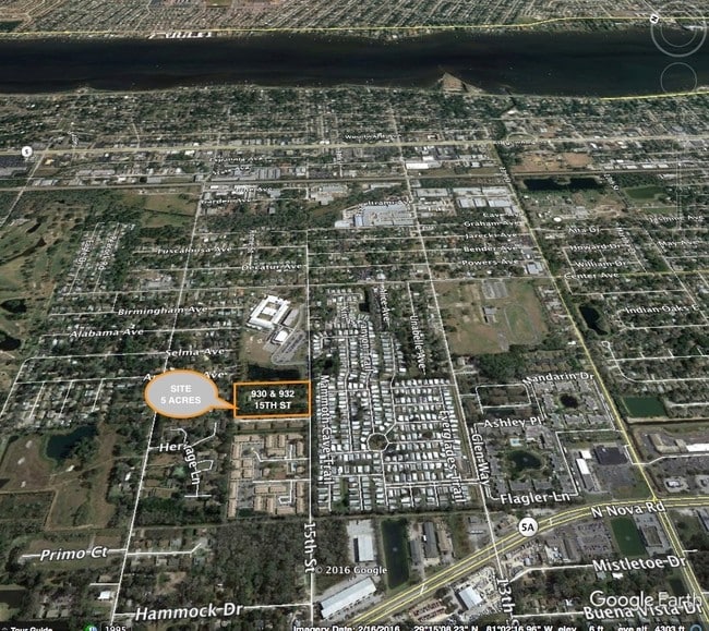
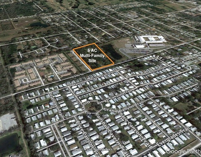
Property Record
932 15Th St, Daytona Beach, FL 32117
NEARBY LISTINGS FOR SALE OR LEASE
Property Detail
932 15Th St
Deltona-Daytona Beach-Ormond Beach, FL
15Th St Flemming Sub Fitch Grant Mb
4242-04-30-0301
Volusia
Sfr
Florida
AE
2.40 AC
12127C0356J
North Daytona Beach
1,620 SF
Deltona/Daytona Beach
DEMOGRAPHICS near 932 15Th St
1 Mile
3 Mile
5 Mile
2024 Total Population
10,773
75,507
128,091
2029 Population
11,905
84,520
143,882
Pop Growth 2024-2029
+ 10.51%
+ 11.94%
+ 12.33%
Average Age
43
44
44
2024 Total Households
4,615
33,556
56,952
HH Growth 2024-2029
+ 10.77%
+ 12.37%
+ 12.71%
Median Household Inc
$42,718
$45,383
$49,977
Avg Household Size
2.20
2.10
2.10
2024 Avg HH Vehicles
1.00
2.00
2.00
Median Home Value
$139,194
$182,193
$226,695
Median Year Built
1977
1977
1978
Nearby Places
Map Layers
Map Styles
 Street
 Aerial
- Restaurants
- Banks
- Shops
- Fitness
- Groceries
PUBLIC TRANSPORTATION
AIRPORT
Daytona Beach International
DRIVE
WALK
Distance
Daytona Beach International
15 min
7.6 mi
Freight Ports
Port Canaveral
DRIVE
WALK
Distance
Port Canaveral
92 min
77.3 mi
SALE & LEASE HISTORY
LISTING DATE
SALE/LEASE

Mar 24, 2017
For Sale
Nearby Properties
Address
Land Use
TOTAL SIZE
Lot Size
Zoning
Address
Land Use
TOTAL SIZE
Lot Size
Zoning
849,735 SF
140.62 AC
01A2
Address
Land Use
TOTAL SIZE
Lot Size
Zoning
451,526 SF
17.96 AC
Address
Land Use
TOTAL SIZE
Lot Size
Zoning
293,850 SF
29.38 AC
Address
Land Use
TOTAL SIZE
Lot Size
Zoning
12,394 SF
139.59 AC
Address
Land Use
TOTAL SIZE
Lot Size
Zoning
135,122 SF
78 AC
Address
Land Use
TOTAL SIZE
Lot Size
Zoning
434,487 SF
20.54 AC
Address
Land Use
TOTAL SIZE
Lot Size
Zoning
10,637 SF
0.15 AC
R2
Address
Land Use
TOTAL SIZE
Lot Size
Zoning
300,038 SF
0.22 AC
Address
Land Use
TOTAL SIZE
Lot Size
Zoning
375,572 SF
0.13 AC
R2
Address
Land Use
TOTAL SIZE
Lot Size
Zoning
409,718 SF
12.86 AC
Address
Land Use
TOTAL SIZE
Lot Size
Zoning
359,180 SF
29.73 AC
01A2
Address
Land Use
TOTAL SIZE
Lot Size
Zoning
425,548 SF
10.16 AC
Address
Land Use
TOTAL SIZE
Lot Size
Zoning
346,734 SF
14 AC
Address
Land Use
TOTAL SIZE
Lot Size
Zoning
417,015 SF
27.55 AC
Address
Land Use
TOTAL SIZE
Lot Size
Zoning
318,707 SF
12.16 AC
Address
Land Use
TOTAL SIZE
Lot Size
Zoning
300,760 SF
20.75 AC
Address
Land Use
TOTAL SIZE
Lot Size
Zoning
243,418 SF
2.91 AC
02T1
Address
Land Use
TOTAL SIZE
Lot Size
Zoning
208,825 SF
30.30 AC
02BA
Address
Land Use
TOTAL SIZE
Lot Size
Zoning
155,620 SF
1.81 AC
02T1
Address
Land Use
TOTAL SIZE
Lot Size
Zoning
158,299 SF
22 AC
Address
Land Use
TOTAL SIZE
Lot Size
Zoning
153,293 SF
10.95 AC
Address
Land Use
TOTAL SIZE
Lot Size
Zoning
403,130 SF
28.45 AC
Address
Land Use
TOTAL SIZE
Lot Size
Zoning
259,453 SF
2.07 AC
Address
Land Use
TOTAL SIZE
Lot Size
Zoning
221,679 SF
0.53 AC
09B4
Address
Land Use
TOTAL SIZE
Lot Size
Zoning
209,513 SF
31 AC
Address
Land Use
TOTAL SIZE
Lot Size
Zoning
184,301 SF
50.28 AC
Address
Land Use
TOTAL SIZE
Lot Size
Zoning
102,495 SF
10.81 AC
02R2
Address
Land Use
TOTAL SIZE
Lot Size
Zoning
184,829 SF
9.71 AC
01A2
Address
Land Use
TOTAL SIZE
Lot Size
Zoning
168,456 SF
15.74 AC
Address
Land Use
TOTAL SIZE
Lot Size
Zoning
5,426 SF
6.28 AC
09R9
The World's #1 Commercial Real Estate Marketplace
Connect with us
© 2025 CoStar Group
The information above has been obtained from sources believed reliable. While we do not doubt its accuracy we have not verified it and make no guarantee, warranty or representation about it. It is your responsibility to independently confirm its accuracy and completeness. Any projections, opinions, assumptions, or estimates used are for example only and do not represent the current or future performance of the property. The value of this transaction to you depends on tax and other factors which should be evaluated by your tax, financial, and legal advisors. You and your advisors should conduct a careful, independent investigation of the property to determine to your satisfaction the suitability of the property for your needs.