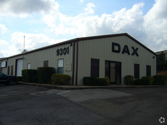
Property Record
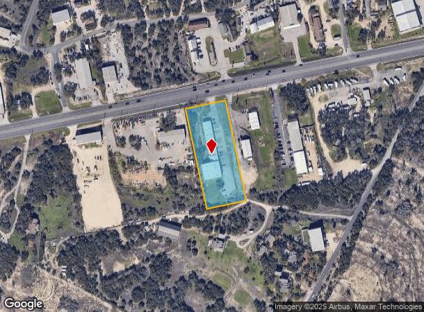
9301 Highway 290 W, Austin, TX 78736

NEARBY LISTINGS FOR SALE OR LEASE
Property Detail
9301 Highway 290 W
Austin-Round Rock, TX
Glen-Ledge Park
315489
LOT 4 GLEN-LEDGE PARK
Warehouse
Travis
X
Texas
48453C0560J
4
2024
2.30 AC
2025
Southwest
031100
Austin
14,450 SF
DEMOGRAPHICS near 9301 Highway 290 W
1 Mile
3 Mile
5 Mile
2024 Total Population
1,894
22,434
81,094
2029 Population
2,034
24,215
90,207
Pop Growth 2024-2029
+ 7.39%
+ 7.94%
+ 11.24%
Average Age
45
40
39
2024 Total Households
734
8,724
30,609
HH Growth 2024-2029
+ 8.04%
+ 8.85%
+ 11.82%
Median Household Inc
$114,958
$115,837
$130,243
Avg Household Size
2.50
2.50
2.60
2024 Avg HH Vehicles
2.00
2.00
2.00
Median Home Value
$742,339
$591,362
$590,270
Median Year Built
1997
2001
2000
Nearby Places
Map Layers
Map Styles
 Street
 Aerial
- Restaurants
- Banks
- Shops
- Fitness
- Groceries
PUBLIC TRANSPORTATION
AIRPORT
Austin-Bergstrom International
DRIVE
WALK
Distance
Austin-Bergstrom International
33 min
19.2 mi
Nearby Properties
Address
Land Use
TOTAL SIZE
Lot Size
Zoning
Address
Land Use
TOTAL SIZE
Lot Size
Zoning
355,651 SF
31.86 AC
Address
Land Use
TOTAL SIZE
Lot Size
Zoning
258,600 SF
36.81 AC
Address
Land Use
TOTAL SIZE
Lot Size
Zoning
339,456 SF
32.70 AC
Address
Land Use
TOTAL SIZE
Lot Size
Zoning
253,902 SF
28.21 AC
Address
Land Use
TOTAL SIZE
Lot Size
Zoning
278,740 SF
44.30 AC
Address
Land Use
TOTAL SIZE
Lot Size
Zoning
240,640 SF
14.36 AC
Address
Land Use
TOTAL SIZE
Lot Size
Zoning
262,421 SF
33.65 AC
Address
Land Use
TOTAL SIZE
Lot Size
Zoning
267,156 SF
45.30 AC
Address
Land Use
TOTAL SIZE
Lot Size
Zoning
82,326 SF
53.78 AC
Address
Land Use
TOTAL SIZE
Lot Size
Zoning
199,816 SF
20.10 AC
Address
Land Use
TOTAL SIZE
Lot Size
Zoning
194,230 SF
11.25 AC
Address
Land Use
TOTAL SIZE
Lot Size
Zoning
82,730 SF
53.28 AC
Address
Land Use
TOTAL SIZE
Lot Size
Zoning
119,556 SF
16.84 AC
Address
Land Use
TOTAL SIZE
Lot Size
Zoning
1,469 SF
51.57 AC
Address
Land Use
TOTAL SIZE
Lot Size
Zoning
4,868 SF
21.77 AC
Address
Land Use
TOTAL SIZE
Lot Size
Zoning
103,045 SF
59.39 AC
Address
Land Use
TOTAL SIZE
Lot Size
Zoning
105,392 SF
7.30 AC
Address
Land Use
TOTAL SIZE
Lot Size
Zoning
88,556 SF
23.15 AC
Address
Land Use
TOTAL SIZE
Lot Size
Zoning
107,654 SF
8.89 AC
Address
Land Use
TOTAL SIZE
Lot Size
Zoning
60,000 SF
5.83 AC
Address
Land Use
TOTAL SIZE
Lot Size
Zoning
42.18 AC
Address
Land Use
TOTAL SIZE
Lot Size
Zoning
14,316 SF
15.09 AC
Address
Land Use
TOTAL SIZE
Lot Size
Zoning
308,500 SF
40 AC
Address
Land Use
TOTAL SIZE
Lot Size
Zoning
37,680 SF
6.16 AC
Address
Land Use
TOTAL SIZE
Lot Size
Zoning
80,750 SF
22.76 AC
Address
Land Use
TOTAL SIZE
Lot Size
Zoning
17.66 AC
Address
Land Use
TOTAL SIZE
Lot Size
Zoning
59,133 SF
13.33 AC
Address
Land Use
TOTAL SIZE
Lot Size
Zoning
84,970 SF
7.19 AC
Address
Land Use
TOTAL SIZE
Lot Size
Zoning
63,392 SF
6.56 AC
Address
Land Use
TOTAL SIZE
Lot Size
Zoning
47,530 SF
16.08 AC
The World's #1 Commercial Real Estate Marketplace
Connect with us
© 2025 CoStar Group
The information above has been obtained from sources believed reliable. While we do not doubt its accuracy we have not verified it and make no guarantee, warranty or representation about it. It is your responsibility to independently confirm its accuracy and completeness. Any projections, opinions, assumptions, or estimates used are for example only and do not represent the current or future performance of the property. The value of this transaction to you depends on tax and other factors which should be evaluated by your tax, financial, and legal advisors. You and your advisors should conduct a careful, independent investigation of the property to determine to your satisfaction the suitability of the property for your needs.