Property Record
933 N 150 W, Springville, UT 84663


NEARBY LISTINGS FOR SALE OR LEASE
Property Detail
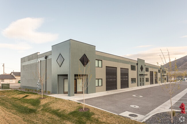
933 N 150 W
Salt Lake City
Salisbury Development Warehouse Storage
Provo-Orem-Lehi, UT
LOT 1, SALISBURY DEVELOPMENT WAREHOUSE STORAGE / OFFICE SUB AREA 1.943 AC.
66-641-0001
Utah
Industrialgeneral
Utah
2024
1
2025
1.94 AC
002901
Utah County
12,202 SF
DEMOGRAPHICS near 933 N 150 W
1 Mile
3 Mile
5 Mile
2024 Total Population
9,068
43,002
122,308
2029 Population
10,528
50,121
143,184
Pop Growth 2024-2029
+ 16.10%
+ 16.56%
+ 17.07%
Average Age
32
32
30
2024 Total Households
2,671
12,647
37,155
HH Growth 2024-2029
+ 16.47%
+ 16.87%
+ 17.48%
Median Household Inc
$73,643
$80,984
$67,935
Avg Household Size
3.30
3.30
3.20
2024 Avg HH Vehicles
2.00
2.00
2.00
Median Home Value
$371,953
$415,800
$429,357
Median Year Built
1993
1995
1992
Nearby Places
Map Layers
Map Styles
 Street
 Aerial
- Restaurants
- Banks
- Shops
- Fitness
- Groceries
PUBLIC TRANSPORTATION
COMMUTER RAIL
Provo Central Station (FrontRunner - Utah Transit Authority (UTA))
DRIVE
WALK
Distance
Provo Central Station (FrontRunner - Utah Transit Authority (UTA))
9 min
4.9 mi
Provo Amtrak (California Zephyr - Amtrak)
DRIVE
WALK
Distance
Provo Amtrak (California Zephyr - Amtrak)
9 min
5.1 mi
AIRPORT
Provo Municipal
DRIVE
WALK
Distance
Provo Municipal
14 min
7.6 mi
Freight Ports
Port of Stockton
DRIVE
WALK
Distance
Port of Stockton
763 min
744.1 mi
SALE & LEASE HISTORY
LISTING DATE
SALE/LEASE

Mar 03, 2020
For Lease
Nearby Properties
Address
Land Use
TOTAL SIZE
Lot Size
Zoning
Address
Land Use
TOTAL SIZE
Lot Size
Zoning
138,990 SF
2.87 AC
Address
Land Use
TOTAL SIZE
Lot Size
Zoning
69,236 SF
30.28 AC
Address
Land Use
TOTAL SIZE
Lot Size
Zoning
286,188 SF
13.63 AC
Address
Land Use
TOTAL SIZE
Lot Size
Zoning
263,859 SF
12.80 AC
Address
Land Use
TOTAL SIZE
Lot Size
Zoning
269,742 SF
16.30 AC
Address
Land Use
TOTAL SIZE
Lot Size
Zoning
671,002 SF
59.02 AC
Address
Land Use
TOTAL SIZE
Lot Size
Zoning
370,735 SF
18.54 AC
Address
Land Use
TOTAL SIZE
Lot Size
Zoning
281,008 SF
14.84 AC
Address
Land Use
TOTAL SIZE
Lot Size
Zoning
301,852 SF
20.24 AC
Address
Land Use
TOTAL SIZE
Lot Size
Zoning
170,774 SF
9.70 AC
Address
Land Use
TOTAL SIZE
Lot Size
Zoning
177,428 SF
9.83 AC
Address
Land Use
TOTAL SIZE
Lot Size
Zoning
210,644 SF
19.55 AC
Address
Land Use
TOTAL SIZE
Lot Size
Zoning
125,729 SF
12.84 AC
Address
Land Use
TOTAL SIZE
Lot Size
Zoning
29,819 SF
13.51 AC
Address
Land Use
TOTAL SIZE
Lot Size
Zoning
386,576 SF
128.19 AC
Address
Land Use
TOTAL SIZE
Lot Size
Zoning
240,674 SF
19.41 AC
Address
Land Use
TOTAL SIZE
Lot Size
Zoning
238,651 SF
14.45 AC
Address
Land Use
TOTAL SIZE
Lot Size
Zoning
151,447 SF
16.14 AC
Address
Land Use
TOTAL SIZE
Lot Size
Zoning
141,566 SF
7.89 AC
Address
Land Use
TOTAL SIZE
Lot Size
Zoning
231,991 SF
13.76 AC
Address
Land Use
TOTAL SIZE
Lot Size
Zoning
79,260 SF
5.24 AC
Address
Land Use
TOTAL SIZE
Lot Size
Zoning
151,447 SF
8.61 AC
Address
Land Use
TOTAL SIZE
Lot Size
Zoning
128,650 SF
10 AC
Address
Land Use
TOTAL SIZE
Lot Size
Zoning
120,613 SF
5.13 AC
Address
Land Use
TOTAL SIZE
Lot Size
Zoning
170,273 SF
9.19 AC
Address
Land Use
TOTAL SIZE
Lot Size
Zoning
136,548 SF
7.67 AC
Address
Land Use
TOTAL SIZE
Lot Size
Zoning
103,642 SF
6.29 AC
Address
Land Use
TOTAL SIZE
Lot Size
Zoning
100,937 SF
6.71 AC
Address
Land Use
TOTAL SIZE
Lot Size
Zoning
112,709 SF
8.10 AC
Address
Land Use
TOTAL SIZE
Lot Size
Zoning
155,605 SF
18.90 AC
The World's #1 Commercial Real Estate Marketplace
Connect with us
© 2026 CoStar Group
The information above has been obtained from sources believed reliable. While we do not doubt its accuracy we have not verified it and make no guarantee, warranty or representation about it. It is your responsibility to independently confirm its accuracy and completeness. Any projections, opinions, assumptions, or estimates used are for example only and do not represent the current or future performance of the property. The value of this transaction to you depends on tax and other factors which should be evaluated by your tax, financial, and legal advisors. You and your advisors should conduct a careful, independent investigation of the property to determine to your satisfaction the suitability of the property for your needs.