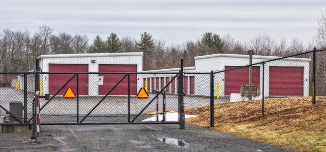
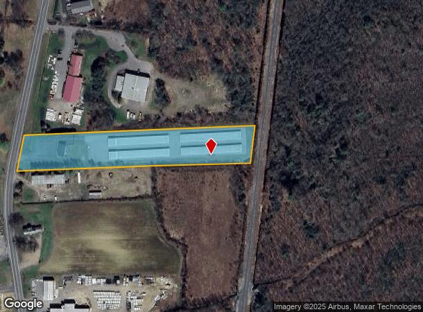
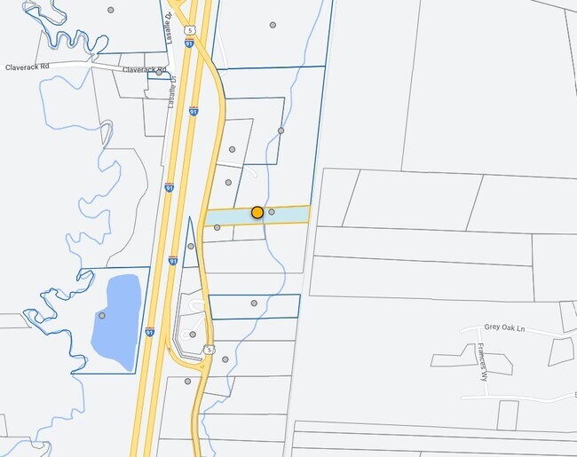
Property Record
94 State Rd, South Deerfield, MA 01373
NEARBY LISTINGS FOR SALE OR LEASE
Property Detail
94 State Rd
Greenfield, MA
Franklin
WHAT-000012-000000-000030-000001
Massachusetts
Commercialnec
30-1
2025
3.22 AC
2025
Franklin County
040800
Hartford
DEMOGRAPHICS near 94 State Rd
1 Mile
3 Mile
5 Mile
2024 Total Population
638
3,618
15,575
2029 Population
613
3,330
13,645
Pop Growth 2024-2029
(3.92%)
(7.96%)
(12.39%)
Average Age
47
44
42
2024 Total Households
273
1,605
6,807
HH Growth 2024-2029
(4.03%)
(8.10%)
(12.28%)
Median Household Inc
$88,725
$74,214
$75,405
Avg Household Size
2.30
2.20
2.20
2024 Avg HH Vehicles
2.00
2.00
2.00
Median Home Value
$375,999
$379,468
$389,925
Median Year Built
1970
1971
1972
Nearby Places
Map Layers
Map Styles
 Street
 Aerial
- Restaurants
- Banks
- Shops
- Fitness
- Groceries
PUBLIC TRANSPORTATION
COMMUTER RAIL
Northampton (Valley Flyer - Amtrak, Vermonter - Amtrak)
DRIVE
WALK
Distance
Northampton (Valley Flyer - Amtrak, Vermonter - Amtrak)
15 min
8.4 mi
Freight Ports
Albany, NY Port
DRIVE
WALK
Distance
Albany, NY Port
123 min
100.3 mi
Nearby Properties
Address
Land Use
TOTAL SIZE
Lot Size
Zoning
Address
Land Use
TOTAL SIZE
Lot Size
Zoning
476,724 SF
57.56 AC
I
Address
Land Use
TOTAL SIZE
Lot Size
Zoning
9.12 AC
VR
Address
Land Use
TOTAL SIZE
Lot Size
Zoning
5.93 AC
VR
Address
Land Use
TOTAL SIZE
Lot Size
Zoning
208,790 SF
44 AC
CI
Address
Land Use
TOTAL SIZE
Lot Size
Zoning
243,750 SF
15.80 AC
MMO
Address
Land Use
TOTAL SIZE
Lot Size
Zoning
8.82 AC
MMO
Address
Land Use
TOTAL SIZE
Lot Size
Zoning
142,167 SF
10 AC
Address
Land Use
TOTAL SIZE
Lot Size
Zoning
33,525 SF
5.36 AC
I
Address
Land Use
TOTAL SIZE
Lot Size
Zoning
4,897 SF
7.63 AC
I
Address
Land Use
TOTAL SIZE
Lot Size
Zoning
7.64 AC
MMO
Address
Land Use
TOTAL SIZE
Lot Size
Zoning
14.79 AC
R4
Address
Land Use
TOTAL SIZE
Lot Size
Zoning
99,595 SF
47 AC
R4
Address
Land Use
TOTAL SIZE
Lot Size
Zoning
29,575 SF
3.52 AC
LGT
Address
Land Use
TOTAL SIZE
Lot Size
Zoning
12.70 AC
CVR
Address
Land Use
TOTAL SIZE
Lot Size
Zoning
990 SF
RRPA
Address
Land Use
TOTAL SIZE
Lot Size
Zoning
56,924 SF
7.50 AC
I
Address
Land Use
TOTAL SIZE
Lot Size
Zoning
27,301 SF
10.40 AC
R4
Address
Land Use
TOTAL SIZE
Lot Size
Zoning
14.87 AC
R6
Address
Land Use
TOTAL SIZE
Lot Size
Zoning
24,976 SF
3.82 AC
LI
Address
Land Use
TOTAL SIZE
Lot Size
Zoning
2.51 AC
RRPA
Address
Land Use
TOTAL SIZE
Lot Size
Zoning
24,360 SF
2.75 AC
LGT
Address
Land Use
TOTAL SIZE
Lot Size
Zoning
47 AC
R4
Address
Land Use
TOTAL SIZE
Lot Size
Zoning
5,559 SF
1.76 AC
CII
Address
Land Use
TOTAL SIZE
Lot Size
Zoning
11,141 SF
15.67 AC
LGT
Address
Land Use
TOTAL SIZE
Lot Size
Zoning
896 SF
18.84 AC
LGT
Address
Land Use
TOTAL SIZE
Lot Size
Zoning
5.49 AC
C
Address
Land Use
TOTAL SIZE
Lot Size
Zoning
29,335 SF
2 AC
I
Address
Land Use
TOTAL SIZE
Lot Size
Zoning
2,233 SF
0.90 AC
C
Address
Land Use
TOTAL SIZE
Lot Size
Zoning
5,026 SF
3.17 AC
R6
The World's #1 Commercial Real Estate Marketplace
Connect with us
© 2026 CoStar Group
The information above has been obtained from sources believed reliable. While we do not doubt its accuracy we have not verified it and make no guarantee, warranty or representation about it. It is your responsibility to independently confirm its accuracy and completeness. Any projections, opinions, assumptions, or estimates used are for example only and do not represent the current or future performance of the property. The value of this transaction to you depends on tax and other factors which should be evaluated by your tax, financial, and legal advisors. You and your advisors should conduct a careful, independent investigation of the property to determine to your satisfaction the suitability of the property for your needs.