Property Record
945 Pomeroy Rd, Nipomo, CA 93444
NEARBY LISTINGS FOR SALE OR LEASE
Property Detail
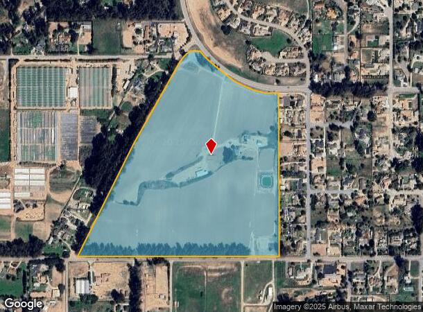
945 Pomeroy Rd
San Luis Obispo-Paso Robles, CA
Los Berros Tr
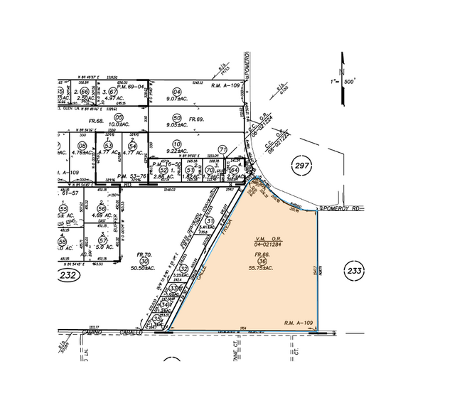
091-232-036
RHO NIP POM DIV B PTN LT 66
Agriculturalland
San Luis Obispo
X
California
06079C1617G
66
2024
55.75 AC
2025
South 101 Corridor
012404
San Luis Obispo/Paso Robles
4,544 SF
DEMOGRAPHICS near 945 Pomeroy Rd
1 mile
3 mile
5 mile
2024 Total Population
2,012
21,284
26,088
2029 Population
1,960
20,821
25,541
Pop Growth 2024-2029
(2.58%)
(2.18%)
(2.10%)
Average Age
49
43
44
2024 Total Households
784
7,586
9,475
HH Growth 2024-2029
(2.55%)
(2.27%)
(2.17%)
Median Household Inc
$102,678
$95,977
$97,764
Avg Household Size
2.50
2.70
2.60
2024 Avg HH Vehicles
2.00
2.00
2.00
Median Home Value
$784,200
$744,037
$752,524
Median Year Built
1991
1990
1991
Nearby Places
Map Layers
Map Styles
 Street
 Aerial
Transit
 Traffic
 Biking
Places
Listings with unknown addresses are not visible on the map
- Restaurants
- Banks
- Shops
- Fitness
- Groceries
PUBLIC TRANSPORTATION
COMMUTER RAIL
Guadalupe Amtrak Station (Pacific Surfliner - Amtrak)
Drive
Walk
Distance
Guadalupe Amtrak Station (Pacific Surfliner - Amtrak)
14 min
9.4 mi
AIRPORT
San Luis County Regional
Drive
Walk
Distance
San Luis County Regional
30 min
18.7 mi
Freight Ports
The Port of Hueneme
Drive
Walk
Distance
The Port of Hueneme
147 min
111.9 mi
SALE & LEASE HISTORY
LISTING DATE
SALE/LEASE

May 15, 2024
For Sale
Nearby Properties
Address
Land Use
TOTAL SIZE
Lot Size
Zoning
Address
Land Use
TOTAL SIZE
Lot Size
Zoning
81,330 SF
4.15 AC
CR
Address
Land Use
TOTAL SIZE
Lot Size
Zoning
2.61 AC
RMF
Address
Land Use
TOTAL SIZE
Lot Size
Zoning
4.50 AC
RMF
Address
Land Use
TOTAL SIZE
Lot Size
Zoning
728 SF
4.50 AC
PF
Address
Land Use
TOTAL SIZE
Lot Size
Zoning
43.16 AC
RR
Address
Land Use
TOTAL SIZE
Lot Size
Zoning
124,604 SF
10.51 AC
IND
Address
Land Use
TOTAL SIZE
Lot Size
Zoning
3.11 AC
RMF
Address
Land Use
TOTAL SIZE
Lot Size
Zoning
34.30 AC
RR
Address
Land Use
TOTAL SIZE
Lot Size
Zoning
4 AC
RMF
Address
Land Use
TOTAL SIZE
Lot Size
Zoning
Address
Land Use
TOTAL SIZE
Lot Size
Zoning
276.22 AC
Address
Land Use
TOTAL SIZE
Lot Size
Zoning
41,631 SF
4.45 AC
CR
Address
Land Use
TOTAL SIZE
Lot Size
Zoning
20,118 SF
2.11 AC
CR
Address
Land Use
TOTAL SIZE
Lot Size
Zoning
18,065 SF
1.01 AC
CR
Address
Land Use
TOTAL SIZE
Lot Size
Zoning
71.70 AC
RR
Address
Land Use
TOTAL SIZE
Lot Size
Zoning
39,348 SF
3.53 AC
CS
Address
Land Use
TOTAL SIZE
Lot Size
Zoning
39.09 AC
RR
Address
Land Use
TOTAL SIZE
Lot Size
Zoning
87,964 SF
4.67 AC
IND
Address
Land Use
TOTAL SIZE
Lot Size
Zoning
216.60 AC
AG
Address
Land Use
TOTAL SIZE
Lot Size
Zoning
31,790 SF
2.28 AC
CS
Address
Land Use
TOTAL SIZE
Lot Size
Zoning
57,000 SF
3.16 AC
CS
Address
Land Use
TOTAL SIZE
Lot Size
Zoning
16,140 SF
1.36 AC
CS
Address
Land Use
TOTAL SIZE
Lot Size
Zoning
16,640 SF
1.92 AC
CR
Address
Land Use
TOTAL SIZE
Lot Size
Zoning
5,051 SF
34.20 AC
RR
Address
Land Use
TOTAL SIZE
Lot Size
Zoning
1.26 AC
RMF
Address
Land Use
TOTAL SIZE
Lot Size
Zoning
3,330 SF
142 AC
AG
Address
Land Use
TOTAL SIZE
Lot Size
Zoning
2,520 SF
39.20 AC
RR
Address
Land Use
TOTAL SIZE
Lot Size
Zoning
35,680 SF
3.86 AC
CR
Address
Land Use
TOTAL SIZE
Lot Size
Zoning
4,738 SF
90 AC
RR
Address
Land Use
TOTAL SIZE
Lot Size
Zoning
19.51 AC
The World's #1 Commercial Real Estate Marketplace
Connect with us
© 2026 CoStar Group
The information above has been obtained from sources believed reliable. While we do not doubt its accuracy we have not verified it and make no guarantee, warranty or representation about it. It is your responsibility to independently confirm its accuracy and completeness. Any projections, opinions, assumptions, or estimates used are for example only and do not represent the current or future performance of the property. The value of this transaction to you depends on tax and other factors which should be evaluated by your tax, financial, and legal advisors. You and your advisors should conduct a careful, independent investigation of the property to determine to your satisfaction the suitability of the property for your needs.