Property Record
950 4Th St, Santa Monica, CA 90403
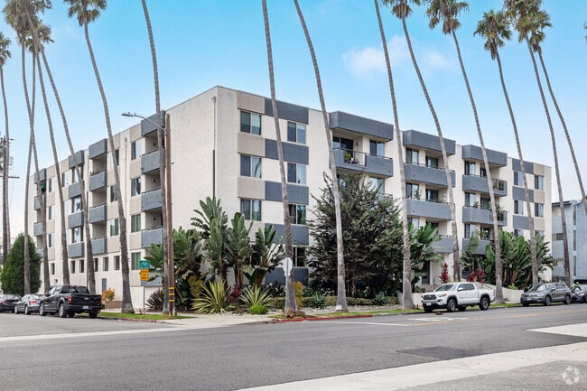


Property Detail
950 4Th St
4292-018-028
SANTA MONICA LOTS J, K AND LOT L BLK 48
Multifamilydwelling
Los Angeles
SMR3*
California
B and X Area of moderate flood hazard, usually the area between the limits of the 100-year and 500-year floods.
j,k,l
2025
0.52 AC
2025
Wilshire Montana
701402
Los Angeles
54,995 SF
Los Angeles-Long Beach-Glendale, CA
NEARBY LISTINGS FOR SALE OR LEASE
DEMOGRAPHICS near 950 4Th St
1 mile
3 mile
5 mile
2025 Total Population
35,683
161,716
384,170
2030 Population
36,368
163,014
387,007
Pop Growth 2025-2030
+ 1.92%
+ 0.80%
+ 0.74%
Average Age
44
43
41
2025 Total Households
20,112
79,779
176,427
HH Growth 2025-2030
+ 1.88%
+ 0.73%
+ 0.67%
Median Household Inc
$113,640
$119,511
$120,144
Avg Household Size
1.70
2.00
2.00
2025 Avg HH Vehicles
1.00
1.00
1.00
Median Home Value
$1,121,901
$1,127,696
$1,119,759
Median Year Built
1971
1968
1971
Nearby Places
Map Layers
Map Styles
 Street
 Aerial
Layers
 Traffic
 Biking
Places
Listings with unknown addresses are not visible on the map
- Restaurants
- Banks
- Shops
- Fitness
- Groceries
PUBLIC TRANSPORTATION
TRANSIT/SUBWAY
Downtown Santa Monica (Expo Line - Los Angeles County Metropolitan Transportation Authority (Metro))
Drive
Walk
Distance
Downtown Santa Monica (Expo Line - Los Angeles County Metropolitan Transportation Authority (Metro))
3 min
17 min
0.9 mi
AIRPORT
Los Angeles International
Drive
Walk
Distance
Los Angeles International
20 min
9.5 mi
Bob Hope
Drive
Walk
Distance
Bob Hope
35 min
23.3 mi
Long Beach (Daugherty Field)
Drive
Walk
Distance
Long Beach (Daugherty Field)
40 min
29.7 mi
Freight Ports
Port of Long Beach
Drive
Walk
Distance
Port of Long Beach
42 min
31.6 mi
Nearby Properties
Address
Land Use
TOTAL SIZE
Lot Size
Zoning
Address
Land Use
TOTAL SIZE
Lot Size
Zoning
486,993 SF
8.31 AC
SMCP3-CP5*
Address
Land Use
TOTAL SIZE
Lot Size
Zoning
318,556 SF
3.19 AC
SMC5*
Address
Land Use
TOTAL SIZE
Lot Size
Zoning
197,520 SF
0.81 AC
SMRVC*
Address
Land Use
TOTAL SIZE
Lot Size
Zoning
301,579 SF
2.69 AC
SMRVC*
Address
Land Use
TOTAL SIZE
Lot Size
Zoning
858,380 SF
7.23 AC
SMC5*
Address
Land Use
TOTAL SIZE
Lot Size
Zoning
35,635 SF
2.81 AC
LAC2
Address
Land Use
TOTAL SIZE
Lot Size
Zoning
483,875 SF
7.31 AC
SMC5*
Address
Land Use
TOTAL SIZE
Lot Size
Zoning
475,736 SF
4.94 AC
SMC3C*
Address
Land Use
TOTAL SIZE
Lot Size
Zoning
424,403 SF
1.76 AC
SMLMSD*
Address
Land Use
TOTAL SIZE
Lot Size
Zoning
208,783 SF
2.94 AC
SMLMSD*
Address
Land Use
TOTAL SIZE
Lot Size
Zoning
492,346 SF
6.79 AC
MOM*
Address
Land Use
TOTAL SIZE
Lot Size
Zoning
178,691 SF
3.42 AC
SMRMH*
Address
Land Use
TOTAL SIZE
Lot Size
Zoning
322,769 SF
3.61 AC
SMC5*
Address
Land Use
TOTAL SIZE
Lot Size
Zoning
172,273 SF
1.21 AC
SMC3
Address
Land Use
TOTAL SIZE
Lot Size
Zoning
102,157 SF
0.71 AC
SMRVC*
Address
Land Use
TOTAL SIZE
Lot Size
Zoning
350,132 SF
3.91 AC
SMC5*
Address
Land Use
TOTAL SIZE
Lot Size
Zoning
73,316 SF
2.07 AC
SMLMSD*
Address
Land Use
TOTAL SIZE
Lot Size
Zoning
355,770 SF
1.12 AC
LAC2
Address
Land Use
TOTAL SIZE
Lot Size
Zoning
126,282 SF
0.86 AC
SMC3-R3A*
Address
Land Use
TOTAL SIZE
Lot Size
Zoning
293,240 SF
3.35 AC
SMC5*
Address
Land Use
TOTAL SIZE
Lot Size
Zoning
321,111 SF
3.31 AC
SMCC*
Address
Land Use
TOTAL SIZE
Lot Size
Zoning
89,748 SF
2.13 AC
Address
Land Use
TOTAL SIZE
Lot Size
Zoning
419,445 SF
2.81 AC
LAC2
Address
Land Use
TOTAL SIZE
Lot Size
Zoning
532,416 SF
4.96 AC
SMOP4*
Address
Land Use
TOTAL SIZE
Lot Size
Zoning
417,650 SF
7.43 AC
LAM2
Address
Land Use
TOTAL SIZE
Lot Size
Zoning
189,347 SF
4.34 AC
SMC5*
Address
Land Use
TOTAL SIZE
Lot Size
Zoning
285,379 SF
0.56 AC
SMRVC*
Address
Land Use
TOTAL SIZE
Lot Size
Zoning
102,157 SF
0.50 AC
SMBSC4*
Address
Land Use
TOTAL SIZE
Lot Size
Zoning
205,608 SF
1.80 AC
SMC5*
Address
Land Use
TOTAL SIZE
Lot Size
Zoning
134,495 SF
1.42 AC
SMRVC*
The World's #1 Commercial Real Estate Marketplace
Connect with us
© 2026 CoStar Group
The information above has been obtained from sources believed reliable. While we do not doubt its accuracy we have not verified it and make no guarantee, warranty or representation about it. It is your responsibility to independently confirm its accuracy and completeness. Any projections, opinions, assumptions, or estimates used are for example only and do not represent the current or future performance of the property. The value of this transaction to you depends on tax and other factors which should be evaluated by your tax, financial, and legal advisors. You and your advisors should conduct a careful, independent investigation of the property to determine to your satisfaction the suitability of the property for your needs.