Property Record
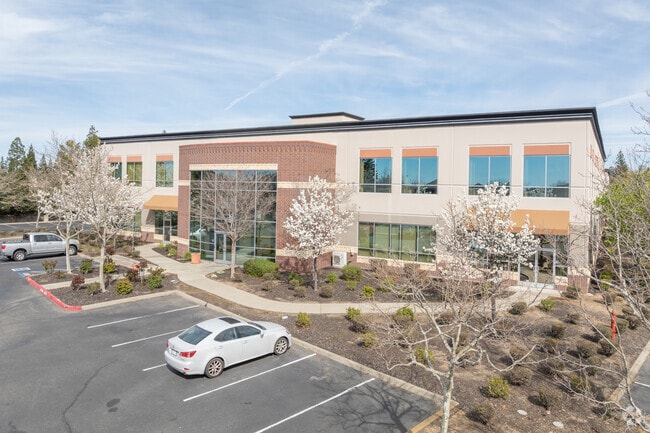
950 Iron Point Rd, Folsom, CA 95630


NEARBY LISTINGS FOR SALE OR LEASE
Property Detail
950 Iron Point Rd
Sacramento--Roseville--Arden-Arcade, CA
Parcel Map
072-0840-049
PARCEL MAP, LOT 1
Officebuilding
Sacramento
X
California
06067C0118J
1
2024
6.98 AC
2025
Folsom
008504
Sacramento
107,817 SF
DEMOGRAPHICS near 950 Iron Point Rd
1 Mile
3 Mile
5 Mile
2024 Total Population
4,990
55,505
149,178
2029 Population
5,070
56,006
150,456
Pop Growth 2024-2029
+ 1.60%
+ 0.90%
+ 0.86%
Average Age
38
41
42
2024 Total Households
1,889
22,345
56,300
HH Growth 2024-2029
+ 1.48%
+ 0.90%
+ 0.84%
Median Household Inc
$133,876
$106,293
$113,656
Avg Household Size
2.60
2.40
2.50
2024 Avg HH Vehicles
2.00
2.00
2.00
Median Home Value
$693,248
$639,550
$674,384
Median Year Built
1996
1990
1988
Nearby Places
Map Layers
Map Styles
 Street
 Aerial
- Restaurants
- Banks
- Shops
- Fitness
- Groceries
PUBLIC TRANSPORTATION
AIRPORT
Sacramento International
DRIVE
WALK
Distance
Sacramento International
42 min
31.9 mi
SALE & LEASE HISTORY
LISTING DATE
SALE/LEASE

Sep 24, 2016
For Lease
Oct 23, 2018
For Lease
Dec 28, 2020
For Lease
Aug 03, 2017
For Lease
Nearby Properties
Address
Land Use
TOTAL SIZE
Lot Size
Zoning
Address
Land Use
TOTAL SIZE
Lot Size
Zoning
1,686,420 SF
161.78 AC
M-1 (PD)
Address
Land Use
TOTAL SIZE
Lot Size
Zoning
278,000 SF
28.48 AC
SP-LI/BP (
Address
Land Use
TOTAL SIZE
Lot Size
Zoning
311,043 SF
10.10 AC
R-4 (PD)
Address
Land Use
TOTAL SIZE
Lot Size
Zoning
302,124 SF
13.30 AC
R-M (PD)
Address
Land Use
TOTAL SIZE
Lot Size
Zoning
129,465 SF
8.30 AC
C-1 (PD)
Address
Land Use
TOTAL SIZE
Lot Size
Zoning
SPA (ASPA)
Address
Land Use
TOTAL SIZE
Lot Size
Zoning
304,607 SF
14.70 AC
LC
Address
Land Use
TOTAL SIZE
Lot Size
Zoning
221,948 SF
15.94 AC
R-M (PD)
Address
Land Use
TOTAL SIZE
Lot Size
Zoning
115,076 SF
22.09 AC
SP-INDUSTR
Address
Land Use
TOTAL SIZE
Lot Size
Zoning
6.02 AC
C-3 (PD)
Address
Land Use
TOTAL SIZE
Lot Size
Zoning
121,378 SF
11.29 AC
M-L (PD)
Address
Land Use
TOTAL SIZE
Lot Size
Zoning
287,131 SF
32.53 AC
C-3 (PD)
Address
Land Use
TOTAL SIZE
Lot Size
Zoning
289,557 SF
28.31 AC
R-M (PD)
Address
Land Use
TOTAL SIZE
Lot Size
Zoning
202,776 SF
12.17 AC
RD-25 (PC)
Address
Land Use
TOTAL SIZE
Lot Size
Zoning
415,320 SF
32.51 AC
R-M (PD) O
Address
Land Use
TOTAL SIZE
Lot Size
Zoning
140,000 SF
4.12 AC
BP (PD)
Address
Land Use
TOTAL SIZE
Lot Size
Zoning
269,928 SF
246.95 AC
SPA
Address
Land Use
TOTAL SIZE
Lot Size
Zoning
2,146.73 AC
SPA
Address
Land Use
TOTAL SIZE
Lot Size
Zoning
296,680 SF
15.65 AC
R-M (PD)
Address
Land Use
TOTAL SIZE
Lot Size
Zoning
40,447 SF
8.89 AC
M-1
Address
Land Use
TOTAL SIZE
Lot Size
Zoning
241,672 SF
18.54 AC
SC
Address
Land Use
TOTAL SIZE
Lot Size
Zoning
5.73 AC
R-4 (PD)
Address
Land Use
TOTAL SIZE
Lot Size
Zoning
14.54 AC
SPA (ASPA)
Address
Land Use
TOTAL SIZE
Lot Size
Zoning
163,800 SF
9.13 AC
SP-IND/OP
Address
Land Use
TOTAL SIZE
Lot Size
Zoning
293,505 SF
27.52 AC
R-M (PD)
Address
Land Use
TOTAL SIZE
Lot Size
Zoning
100,053 SF
7.80 AC
M-L (PD)
Address
Land Use
TOTAL SIZE
Lot Size
Zoning
55,579 SF
44.38 AC
M-2
Address
Land Use
TOTAL SIZE
Lot Size
Zoning
52,992 SF
4.07 AC
M-1 (PD)
Address
Land Use
TOTAL SIZE
Lot Size
Zoning
54,336 SF
4.88 AC
BP (PD)
Address
Land Use
TOTAL SIZE
Lot Size
Zoning
153,983 SF
4.16 AC
MU
The World's #1 Commercial Real Estate Marketplace
Connect with us
© 2026 CoStar Group
The information above has been obtained from sources believed reliable. While we do not doubt its accuracy we have not verified it and make no guarantee, warranty or representation about it. It is your responsibility to independently confirm its accuracy and completeness. Any projections, opinions, assumptions, or estimates used are for example only and do not represent the current or future performance of the property. The value of this transaction to you depends on tax and other factors which should be evaluated by your tax, financial, and legal advisors. You and your advisors should conduct a careful, independent investigation of the property to determine to your satisfaction the suitability of the property for your needs.