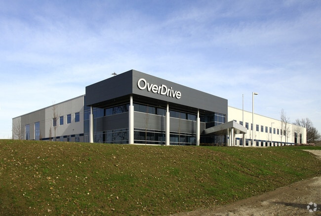
Property Record
9501 Granger Rd, Cleveland, OH 44125

NEARBY LISTINGS FOR SALE OR LEASE
Property Detail
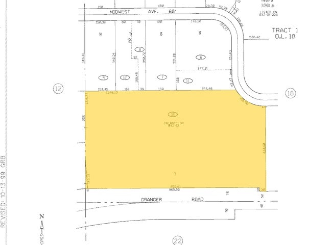
9501 Granger Rd
542-12-018
Parcel #1
Industrialgeneral
PARCEL #1 - AFN 201906240355
X
Cuyahoga
39035C0211E
Ohio
2024
18.36 AC
2024
Brooklyn Hts
154501
Cleveland
133,913 SF
Cleveland-Elyria, OH
DEMOGRAPHICS near 9501 Granger Rd
1 Mile
3 Mile
5 Mile
2024 Total Population
10,447
68,475
225,194
2029 Population
10,058
66,526
219,275
Pop Growth 2024-2029
(3.72%)
(2.85%)
(2.63%)
Average Age
39
40
41
2024 Total Households
4,162
28,318
97,768
HH Growth 2024-2029
(3.89%)
(3.07%)
(2.83%)
Median Household Inc
$49,668
$43,103
$44,695
Avg Household Size
2.40
2.30
2.20
2024 Avg HH Vehicles
2.00
1.00
1.00
Median Home Value
$67,865
$75,704
$98,041
Median Year Built
1951
1951
1951
Nearby Places
Map Layers
Map Styles
 Street
 Aerial
- Restaurants
- Banks
- Shops
- Fitness
- Groceries
PUBLIC TRANSPORTATION
COMMUTER RAIL
Rockside (National Park Scenic Railway - Cuyahoga Valley Scenic Railroad)
DRIVE
WALK
Distance
Rockside (National Park Scenic Railway - Cuyahoga Valley Scenic Railroad)
6 min
2.5 mi
Canal Exploration Center (National Park Scenic Railway - Cuyahoga Valley Scenic Railroad)
DRIVE
WALK
Distance
Canal Exploration Center (National Park Scenic Railway - Cuyahoga Valley Scenic Railroad)
8 min
4.2 mi
AIRPORT
Cleveland-Hopkins International
DRIVE
WALK
Distance
Cleveland-Hopkins International
23 min
14.1 mi
Freight Ports
Port of Toledo
DRIVE
WALK
Distance
Port of Toledo
137 min
115.0 mi
Nearby Properties
Address
Land Use
TOTAL SIZE
Lot Size
Zoning
Address
Land Use
TOTAL SIZE
Lot Size
Zoning
162,711 SF
192.04 AC
IG
Address
Land Use
TOTAL SIZE
Lot Size
Zoning
230,820 SF
41.47 AC
UI
Address
Land Use
TOTAL SIZE
Lot Size
Zoning
436,164 SF
20.01 AC
U-5
Address
Land Use
TOTAL SIZE
Lot Size
Zoning
186,275 SF
17.80 AC
U-8
Address
Land Use
TOTAL SIZE
Lot Size
Zoning
384,714 SF
4.75 AC
U-5-HR
Address
Land Use
TOTAL SIZE
Lot Size
Zoning
307,703 SF
47.05 AC
U-5
Address
Land Use
TOTAL SIZE
Lot Size
Zoning
279,200 SF
37.19 AC
IG
Address
Land Use
TOTAL SIZE
Lot Size
Zoning
194,257 SF
94.46 AC
IG
Address
Land Use
TOTAL SIZE
Lot Size
Zoning
129,112 SF
24.11 AC
U-8
Address
Land Use
TOTAL SIZE
Lot Size
Zoning
289,009 SF
25.27 AC
I/O
Address
Land Use
TOTAL SIZE
Lot Size
Zoning
248,498 SF
14.31 AC
U-8
Address
Land Use
TOTAL SIZE
Lot Size
Zoning
227,141 SF
23.76 AC
U-4
Address
Land Use
TOTAL SIZE
Lot Size
Zoning
475,286 SF
5.81 AC
U-5-HR
Address
Land Use
TOTAL SIZE
Lot Size
Zoning
46,250 SF
16.36 AC
U-5
Address
Land Use
TOTAL SIZE
Lot Size
Zoning
239,000 SF
6.29 AC
U-6A
Address
Land Use
TOTAL SIZE
Lot Size
Zoning
60,989 SF
9.31 AC
U-4
Address
Land Use
TOTAL SIZE
Lot Size
Zoning
225,593 SF
4.79 AC
U-6A
Address
Land Use
TOTAL SIZE
Lot Size
Zoning
205,724 SF
6.54 AC
U-8
Address
Land Use
TOTAL SIZE
Lot Size
Zoning
32,400 SF
52.29 AC
U-4
Address
Land Use
TOTAL SIZE
Lot Size
Zoning
189,156 SF
24.49 AC
IG
Address
Land Use
TOTAL SIZE
Lot Size
Zoning
168,322 SF
14.44 AC
Address
Land Use
TOTAL SIZE
Lot Size
Zoning
221,406 SF
12.05 AC
2F
Address
Land Use
TOTAL SIZE
Lot Size
Zoning
500,398 SF
24.49 AC
IG
Address
Land Use
TOTAL SIZE
Lot Size
Zoning
49,998 SF
19.72 AC
U-6
Address
Land Use
TOTAL SIZE
Lot Size
Zoning
209,068 SF
23.10 AC
IG
Address
Land Use
TOTAL SIZE
Lot Size
Zoning
277,049 SF
24.15 AC
2F
Address
Land Use
TOTAL SIZE
Lot Size
Zoning
347,218 SF
0.23 AC
O/I
Address
Land Use
TOTAL SIZE
Lot Size
Zoning
86,900 SF
18.01 AC
U-5
Address
Land Use
TOTAL SIZE
Lot Size
Zoning
65,108 SF
24.93 AC
I/O
The World's #1 Commercial Real Estate Marketplace
Connect with us
© 2025 CoStar Group
The information above has been obtained from sources believed reliable. While we do not doubt its accuracy we have not verified it and make no guarantee, warranty or representation about it. It is your responsibility to independently confirm its accuracy and completeness. Any projections, opinions, assumptions, or estimates used are for example only and do not represent the current or future performance of the property. The value of this transaction to you depends on tax and other factors which should be evaluated by your tax, financial, and legal advisors. You and your advisors should conduct a careful, independent investigation of the property to determine to your satisfaction the suitability of the property for your needs.