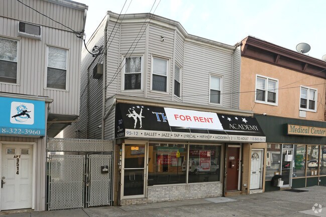
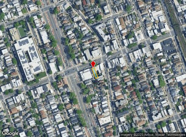
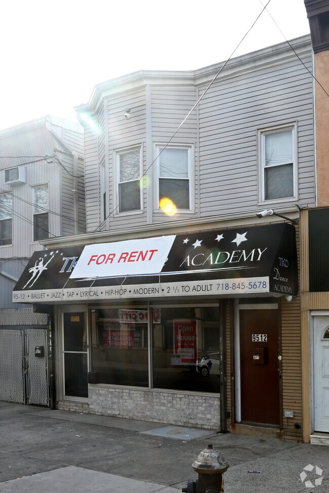
Property Record
9512 101St Ave, Ozone Park, NY 11416
NEARBY LISTINGS FOR SALE OR LEASE
Property Detail
9512 101St Ave
09102-0007
Map #8 Of Woodhaven Centre Property
Commercialofficeresidentialmixeduse
Queens
X
New York
3604970236F
7
2024
0.06 AC
2025
South Queens
004001
Long Island (New York)
1,826 SF
New York-Jersey City-White Plains, NY-NJ
DEMOGRAPHICS near 9512 101St Ave
1 mile
3 mile
5 mile
2024 Total Population
92,315
623,157
1,800,513
2029 Population
83,081
574,674
1,669,443
Pop Growth 2024-2029
(10.00%)
(7.78%)
(7.28%)
Average Age
39
40
40
2024 Total Households
26,517
211,404
614,123
HH Growth 2024-2029
(10.59%)
(7.82%)
(7.52%)
Median Household Inc
$78,014
$71,811
$65,258
Avg Household Size
3.30
2.80
2.80
2024 Avg HH Vehicles
1.00
1.00
1.00
Median Home Value
$720,478
$660,364
$678,461
Median Year Built
1946
1949
1951
Nearby Places
Map Layers
Map Styles
 Street
 Aerial
Transit
 Traffic
 Biking
Places
Listings with unknown addresses are not visible on the map
- Restaurants
- Banks
- Shops
- Fitness
- Groceries
PUBLIC TRANSPORTATION
TRANSIT/SUBWAY
Rockaway Boulevard (A - New York MTA Subway (The Subway))
Drive
Walk
Distance
Rockaway Boulevard (A - New York MTA Subway (The Subway))
1 min
6 min
0.3 mi
88 Street (A - New York MTA Subway (The Subway))
Drive
Walk
Distance
88 Street (A - New York MTA Subway (The Subway))
3 min
11 min
0.6 mi
104 Street (A Line) (A - New York MTA Subway (The Subway))
Drive
Walk
Distance
104 Street (A Line) (A - New York MTA Subway (The Subway))
2 min
12 min
0.6 mi
Woodhaven Boulevard (J,Z Line) (J - New York MTA Subway (The Subway), Z - New York MTA Subway (The Subway))
Drive
Walk
Distance
Woodhaven Boulevard (J,Z Line) (J - New York MTA Subway (The Subway), Z - New York MTA Subway (The Subway))
3 min
16 min
0.8 mi
111 Street (A Line) (A - New York MTA Subway (The Subway))
Drive
Walk
Distance
111 Street (A Line) (A - New York MTA Subway (The Subway))
3 min
19 min
0.9 mi
COMMUTER RAIL
Kew Gardens Station (Babylon Branch - Long Island Rail Road, Hempstead Branch - Long Island Rail Road, Long Beach Branch - Long Island Rail Road, Port Jefferson Branch - Long Island Rail Road)
Drive
Walk
Distance
Kew Gardens Station (Babylon Branch - Long Island Rail Road, Hempstead Branch - Long Island Rail Road, Long Beach Branch - Long Island Rail Road, Port Jefferson Branch - Long Island Rail Road)
7 min
2.6 mi
Jamaica Station (Babylon Branch - Long Island Rail Road, Far Rockaway Branch - Long Island Rail Road, Hempstead Branch - Long Island Rail Road, Long Beach Branch - Long Island Rail Road, Montauk Branch - Long Island Rail Road, Oyster Bay Branch - Long Island Rail Road, Port Jefferson Branch - Long Island Rail Road, Ronkonkoma Branch - Long Island Rail Road, West Hempstead Branch - Long Island Rail Road)
Drive
Walk
Distance
Jamaica Station (Babylon Branch - Long Island Rail Road, Far Rockaway Branch - Long Island Rail Road, Hempstead Branch - Long Island Rail Road, Long Beach Branch - Long Island Rail Road, Montauk Branch - Long Island Rail Road, Oyster Bay Branch - Long Island Rail Road, Port Jefferson Branch - Long Island Rail Road, Ronkonkoma Branch - Long Island Rail Road, West Hempstead Branch - Long Island Rail Road)
8 min
2.8 mi
AIRPORT
John F Kennedy International
Drive
Walk
Distance
John F Kennedy International
11 min
6.2 mi
LaGuardia
Drive
Walk
Distance
LaGuardia
17 min
9.0 mi
Newark Liberty International
Drive
Walk
Distance
Newark Liberty International
41 min
24.7 mi
Freight Ports
NY - Red Hook Container Terminal
Drive
Walk
Distance
NY - Red Hook Container Terminal
23 min
11.8 mi
Nearby Properties
Address
Land Use
TOTAL SIZE
Lot Size
Zoning
Address
Land Use
TOTAL SIZE
Lot Size
Zoning
1,845,252 SF
172 AC
C8-1
Address
Land Use
TOTAL SIZE
Lot Size
Zoning
54,170 SF
229.57 AC
PARK
Address
Land Use
TOTAL SIZE
Lot Size
Zoning
1,688,760 SF
24.65 AC
R5
Address
Land Use
TOTAL SIZE
Lot Size
Zoning
1,516,458 SF
5.97 AC
R7-1
Address
Land Use
TOTAL SIZE
Lot Size
Zoning
532,011 SF
2.48 AC
R6
Address
Land Use
TOTAL SIZE
Lot Size
Zoning
600 SF
33.07 AC
PARK
Address
Land Use
TOTAL SIZE
Lot Size
Zoning
126.85 AC
PARK
Address
Land Use
TOTAL SIZE
Lot Size
Zoning
24,400 SF
33.98 AC
C4-2
Address
Land Use
TOTAL SIZE
Lot Size
Zoning
1,000 SF
210.07 AC
R3-2
Address
Land Use
TOTAL SIZE
Lot Size
Zoning
575,600 SF
2.35 AC
C4-5X
Address
Land Use
TOTAL SIZE
Lot Size
Zoning
575,600 SF
2.35 AC
C4-5X
Address
Land Use
TOTAL SIZE
Lot Size
Zoning
575,600 SF
2.35 AC
C4-5X
Address
Land Use
TOTAL SIZE
Lot Size
Zoning
575,600 SF
2.35 AC
C4-5X
Address
Land Use
TOTAL SIZE
Lot Size
Zoning
575,600 SF
2.35 AC
C4-5X
Address
Land Use
TOTAL SIZE
Lot Size
Zoning
575,600 SF
2.35 AC
C4-5X
Address
Land Use
TOTAL SIZE
Lot Size
Zoning
575,600 SF
2.35 AC
C4-5X
Address
Land Use
TOTAL SIZE
Lot Size
Zoning
575,600 SF
2.35 AC
C4-5X
Address
Land Use
TOTAL SIZE
Lot Size
Zoning
575,600 SF
2.35 AC
C4-5X
Address
Land Use
TOTAL SIZE
Lot Size
Zoning
575,600 SF
2.35 AC
C4-5X
Address
Land Use
TOTAL SIZE
Lot Size
Zoning
575,600 SF
2.35 AC
C4-5X
Address
Land Use
TOTAL SIZE
Lot Size
Zoning
575,600 SF
2.35 AC
C4-5X
Address
Land Use
TOTAL SIZE
Lot Size
Zoning
575,600 SF
2.35 AC
C4-5X
Address
Land Use
TOTAL SIZE
Lot Size
Zoning
575,600 SF
2.35 AC
C4-5X
Address
Land Use
TOTAL SIZE
Lot Size
Zoning
575,600 SF
2.35 AC
C4-5X
Address
Land Use
TOTAL SIZE
Lot Size
Zoning
575,600 SF
2.35 AC
C4-5X
Address
Land Use
TOTAL SIZE
Lot Size
Zoning
575,600 SF
2.35 AC
C4-5X
Address
Land Use
TOTAL SIZE
Lot Size
Zoning
575,600 SF
2.35 AC
C4-5X
Address
Land Use
TOTAL SIZE
Lot Size
Zoning
575,600 SF
2.35 AC
C4-5X
Address
Land Use
TOTAL SIZE
Lot Size
Zoning
575,600 SF
2.35 AC
C4-5X
Address
Land Use
TOTAL SIZE
Lot Size
Zoning
575,600 SF
2.35 AC
C4-5X
The World's #1 Commercial Real Estate Marketplace
Connect with us
© 2026 CoStar Group
The information above has been obtained from sources believed reliable. While we do not doubt its accuracy we have not verified it and make no guarantee, warranty or representation about it. It is your responsibility to independently confirm its accuracy and completeness. Any projections, opinions, assumptions, or estimates used are for example only and do not represent the current or future performance of the property. The value of this transaction to you depends on tax and other factors which should be evaluated by your tax, financial, and legal advisors. You and your advisors should conduct a careful, independent investigation of the property to determine to your satisfaction the suitability of the property for your needs.