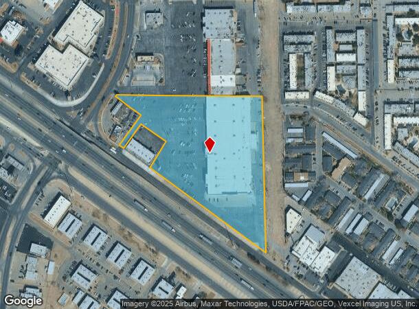
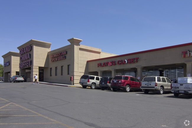
Property Record
9521 Viscount Blvd, El Paso, TX 79925


NEARBY LISTINGS FOR SALE OR LEASE
Property Detail
9521 Viscount Blvd
A765-999-002D-0467
Ascarate
Commercialnec
2 ASCARATE TR 4-A-30-G-1-C (7.4393 AC)
X
El Paso
4802140041C
Texas
2024
7.44 AC
2025
East
004317
El Paso
103,116 SF
El Paso, TX
DEMOGRAPHICS near 9521 Viscount Blvd
1 Mile
3 Mile
5 Mile
2024 Total Population
15,197
104,073
228,216
2029 Population
15,311
104,903
230,352
Pop Growth 2024-2029
+ 0.75%
+ 0.80%
+ 0.94%
Average Age
39
40
39
2024 Total Households
6,217
39,798
82,108
HH Growth 2024-2029
+ 0.80%
+ 0.80%
+ 0.88%
Median Household Inc
$45,393
$43,589
$45,718
Avg Household Size
2.40
2.50
2.70
2024 Avg HH Vehicles
2.00
2.00
2.00
Median Home Value
$149,822
$143,230
$143,664
Median Year Built
1970
1970
1976
Nearby Places
Map Layers
Map Styles
 Street
 Aerial
- Restaurants
- Banks
- Shops
- Fitness
- Groceries
PUBLIC TRANSPORTATION
AIRPORT
El Paso International
DRIVE
WALK
Distance
El Paso International
19 min
7.8 mi
Freight Ports
Port of Corpus Christi
DRIVE
WALK
Distance
Port of Corpus Christi
672 min
687.5 mi
Nearby Properties
Address
Land Use
TOTAL SIZE
Lot Size
Zoning
Address
Land Use
TOTAL SIZE
Lot Size
Zoning
600,211 SF
114.73 AC
RF
Address
Land Use
TOTAL SIZE
Lot Size
Zoning
753,996 SF
23.50 AC
C4
Address
Land Use
TOTAL SIZE
Lot Size
Zoning
1,122,782 SF
55.24 AC
C4
Address
Land Use
TOTAL SIZE
Lot Size
Zoning
1 SF
M1
Address
Land Use
TOTAL SIZE
Lot Size
Zoning
1 SF
214 AC
M3
Address
Land Use
TOTAL SIZE
Lot Size
Zoning
380,811 SF
22.75 AC
M1
Address
Land Use
TOTAL SIZE
Lot Size
Zoning
343,190 SF
31.84 AC
C4
Address
Land Use
TOTAL SIZE
Lot Size
Zoning
1 SF
Address
Land Use
TOTAL SIZE
Lot Size
Zoning
289.07 AC
Address
Land Use
TOTAL SIZE
Lot Size
Zoning
135,639 SF
211.63 AC
C4
Address
Land Use
TOTAL SIZE
Lot Size
Zoning
377,168 SF
8.40 AC
C1
Address
Land Use
TOTAL SIZE
Lot Size
Zoning
195,101 SF
15.45 AC
C1
Address
Land Use
TOTAL SIZE
Lot Size
Zoning
271,746 SF
1.93 AC
C4
Address
Land Use
TOTAL SIZE
Lot Size
Zoning
190,770 SF
8.70 AC
C4S
Address
Land Use
TOTAL SIZE
Lot Size
Zoning
125,896 SF
8.67 AC
R3
Address
Land Use
TOTAL SIZE
Lot Size
Zoning
206,726 SF
24.42 AC
M1S
Address
Land Use
TOTAL SIZE
Lot Size
Zoning
196,860 SF
10.15 AC
C4
Address
Land Use
TOTAL SIZE
Lot Size
Zoning
272,601 SF
14.97 AC
AO
Address
Land Use
TOTAL SIZE
Lot Size
Zoning
197,902 SF
30 AC
R4
Address
Land Use
TOTAL SIZE
Lot Size
Zoning
259,968 SF
10.54 AC
AO
Address
Land Use
TOTAL SIZE
Lot Size
Zoning
184,016 SF
14.17 AC
C4
Address
Land Use
TOTAL SIZE
Lot Size
Zoning
269,974 SF
15.87 AC
A2S
Address
Land Use
TOTAL SIZE
Lot Size
Zoning
235,213 SF
11.98 AC
A3O
Address
Land Use
TOTAL SIZE
Lot Size
Zoning
174,369 SF
6.47 AC
C4
Address
Land Use
TOTAL SIZE
Lot Size
Zoning
333,673 SF
15 AC
AO
Address
Land Use
TOTAL SIZE
Lot Size
Zoning
83,251 SF
2.43 AC
M1
Address
Land Use
TOTAL SIZE
Lot Size
Zoning
109,578 SF
17.84 AC
RF
Address
Land Use
TOTAL SIZE
Lot Size
Zoning
186,950 SF
14.30 AC
C1
Address
Land Use
TOTAL SIZE
Lot Size
Zoning
189,234 SF
10.01 AC
AO
Address
Land Use
TOTAL SIZE
Lot Size
Zoning
341,541 SF
22.51 AC
A2
The World's #1 Commercial Real Estate Marketplace
Connect with us
© 2026 CoStar Group
The information above has been obtained from sources believed reliable. While we do not doubt its accuracy we have not verified it and make no guarantee, warranty or representation about it. It is your responsibility to independently confirm its accuracy and completeness. Any projections, opinions, assumptions, or estimates used are for example only and do not represent the current or future performance of the property. The value of this transaction to you depends on tax and other factors which should be evaluated by your tax, financial, and legal advisors. You and your advisors should conduct a careful, independent investigation of the property to determine to your satisfaction the suitability of the property for your needs.