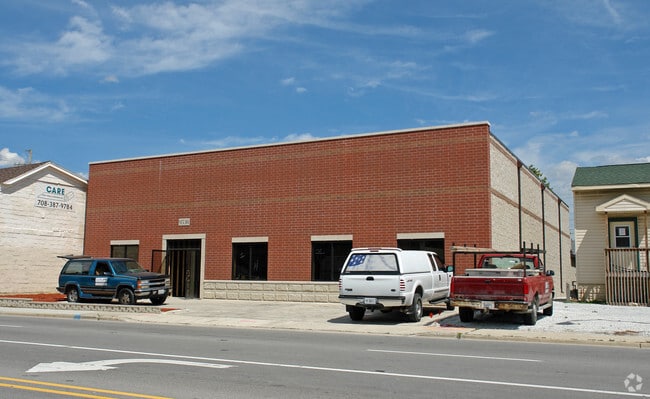
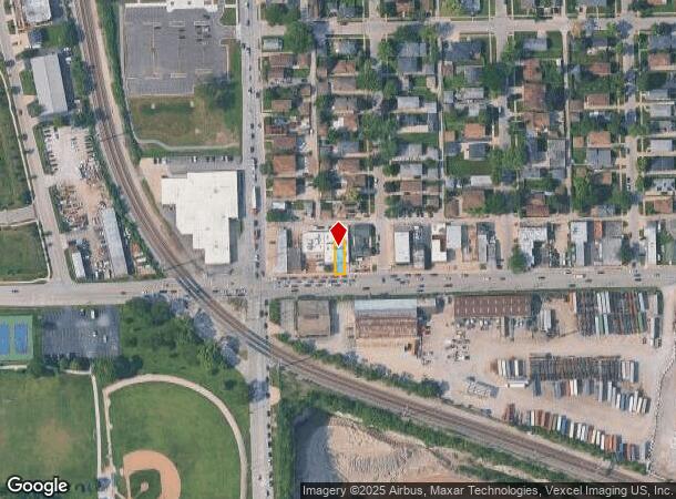
Property Record
9538 47Th St, Brookfield, IL 60513

NEARBY LISTINGS FOR SALE OR LEASE
Property Detail
9538 47Th St
Chicago-Naperville-Elgin, IL-IN
West Grossdale
18-03-322-046-0000
(WEST)(GROSSDALE) SUB OF PT OF WH WH SEC 03-38-12
Industrialgeneral
Cook
X
Illinois
17031C0486J
22-24
2023
0.68 AC
2025
West Cook South
819400
Chicago
DEMOGRAPHICS near 9538 47Th St
1 Mile
3 Mile
5 Mile
2024 Total Population
16,508
103,011
309,550
2029 Population
16,013
100,064
300,511
Pop Growth 2024-2029
(3.00%)
(2.86%)
(2.92%)
Average Age
40
41
41
2024 Total Households
6,029
37,680
112,152
HH Growth 2024-2029
(3.40%)
(3.23%)
(3.21%)
Median Household Inc
$94,940
$98,071
$85,389
Avg Household Size
2.60
2.60
2.70
2024 Avg HH Vehicles
2.00
2.00
2.00
Median Home Value
$363,243
$370,461
$296,834
Median Year Built
1954
1956
1957
Nearby Places
Map Layers
Map Styles
 Street
 Aerial
- Restaurants
- Banks
- Shops
- Fitness
- Groceries
PUBLIC TRANSPORTATION
COMMUTER RAIL
Congress Park Station (Burlington Northern-Santa Fe Railway Line - Northeast Illinois Regional Commuter Railroad (Metra))
DRIVE
WALK
Distance
Congress Park Station (Burlington Northern-Santa Fe Railway Line - Northeast Illinois Regional Commuter Railroad (Metra))
5 min
20 min
1.0 mi
LaGrange Road Station (Burlington Northern-Santa Fe Railway Line - Northeast Illinois Regional Commuter Railroad (Metra))
DRIVE
WALK
Distance
LaGrange Road Station (Burlington Northern-Santa Fe Railway Line - Northeast Illinois Regional Commuter Railroad (Metra))
4 min
1.4 mi
AIRPORT
Chicago Midway International
DRIVE
WALK
Distance
Chicago Midway International
11 min
6.1 mi
Chicago O'Hare International
DRIVE
WALK
Distance
Chicago O'Hare International
27 min
14.9 mi
Nearby Properties
Address
Land Use
TOTAL SIZE
Lot Size
Zoning
Address
Land Use
TOTAL SIZE
Lot Size
Zoning
1,182,079 SF
Address
Land Use
TOTAL SIZE
Lot Size
Zoning
134,361 SF
4.09 AC
Address
Land Use
TOTAL SIZE
Lot Size
Zoning
424,376 SF
3.48 AC
Address
Land Use
TOTAL SIZE
Lot Size
Zoning
246,248 SF
19.35 AC
Address
Land Use
TOTAL SIZE
Lot Size
Zoning
445,440 SF
24.50 AC
Address
Land Use
TOTAL SIZE
Lot Size
Zoning
140,814 SF
Address
Land Use
TOTAL SIZE
Lot Size
Zoning
137,144 SF
11.77 AC
Address
Land Use
TOTAL SIZE
Lot Size
Zoning
140,579 SF
11.30 AC
Address
Land Use
TOTAL SIZE
Lot Size
Zoning
49,503 SF
1.47 AC
Address
Land Use
TOTAL SIZE
Lot Size
Zoning
274,900 SF
13.14 AC
Address
Land Use
TOTAL SIZE
Lot Size
Zoning
313,899 SF
13.43 AC
Address
Land Use
TOTAL SIZE
Lot Size
Zoning
Address
Land Use
TOTAL SIZE
Lot Size
Zoning
124.04 AC
Address
Land Use
TOTAL SIZE
Lot Size
Zoning
11.53 AC
Address
Land Use
TOTAL SIZE
Lot Size
Zoning
365,359 SF
25.39 AC
Address
Land Use
TOTAL SIZE
Lot Size
Zoning
Address
Land Use
TOTAL SIZE
Lot Size
Zoning
98,811 SF
10.02 AC
Address
Land Use
TOTAL SIZE
Lot Size
Zoning
99.88 AC
Address
Land Use
TOTAL SIZE
Lot Size
Zoning
317,321 SF
15.99 AC
Address
Land Use
TOTAL SIZE
Lot Size
Zoning
117,394 SF
9.33 AC
Address
Land Use
TOTAL SIZE
Lot Size
Zoning
358,212 SF
17.87 AC
Address
Land Use
TOTAL SIZE
Lot Size
Zoning
188,000 SF
8.91 AC
Address
Land Use
TOTAL SIZE
Lot Size
Zoning
123,388 SF
11.14 AC
Address
Land Use
TOTAL SIZE
Lot Size
Zoning
46,244 SF
3.16 AC
Address
Land Use
TOTAL SIZE
Lot Size
Zoning
1,583,756 SF
78.72 AC
Address
Land Use
TOTAL SIZE
Lot Size
Zoning
303,192 SF
15.47 AC
Address
Land Use
TOTAL SIZE
Lot Size
Zoning
226,088 SF
12.95 AC
Address
Land Use
TOTAL SIZE
Lot Size
Zoning
80.10 AC
Address
Land Use
TOTAL SIZE
Lot Size
Zoning
15,600 SF
9.35 AC
Address
Land Use
TOTAL SIZE
Lot Size
Zoning
The World's #1 Commercial Real Estate Marketplace
Connect with us
© 2026 CoStar Group
The information above has been obtained from sources believed reliable. While we do not doubt its accuracy we have not verified it and make no guarantee, warranty or representation about it. It is your responsibility to independently confirm its accuracy and completeness. Any projections, opinions, assumptions, or estimates used are for example only and do not represent the current or future performance of the property. The value of this transaction to you depends on tax and other factors which should be evaluated by your tax, financial, and legal advisors. You and your advisors should conduct a careful, independent investigation of the property to determine to your satisfaction the suitability of the property for your needs.