Property Record
955 W 170 N, Payson, UT 84651
NEARBY LISTINGS FOR SALE OR LEASE
Property Detail
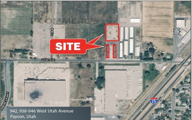
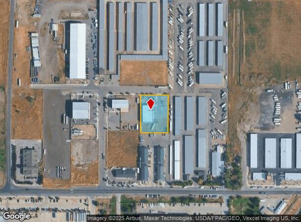
955 W 170 N
Salt Lake City
West Utah Ave
Provo-Orem-Lehi, UT
PART LOT 2, PLAT A, WEST UTAH AVE SUB DESCRIBED AS FOLLOWS; COM S 1192.24 FT & E 41.49 FT FR W 1/4 COR. SEC. 8, T9S, R2E, SLB&M.; S 89 DEG 36 11 E 170.02 FT; S 0 DEG 50 0 W 228.97 FT; N 89 DEG 25 41 W 165.84 FT; N 0 DEG 12 8 E 143.52 FT; N 0 DEG 54 5
55-737-0002
Utah
Scientificpharmaceuticalmedicalresearchfacility
Utah
2024
2
2025
0.88 AC
010504
Utah County
7,483 SF
DEMOGRAPHICS near 955 W 170 N
1 mile
3 mile
5 mile
2024 Total Population
5,847
26,574
49,942
2029 Population
6,808
31,197
58,655
Pop Growth 2024-2029
+ 16.44%
+ 17.40%
+ 17.45%
Average Age
33
33
33
2024 Total Households
1,759
7,568
13,721
HH Growth 2024-2029
+ 16.77%
+ 17.72%
+ 17.80%
Median Household Inc
$72,429
$80,691
$90,019
Avg Household Size
3.30
3.50
3.60
2024 Avg HH Vehicles
2.00
3.00
3.00
Median Home Value
$356,798
$392,626
$445,427
Median Year Built
1977
1996
2000
Nearby Places
Map Layers
Map Styles
 Street
 Aerial
Transit
 Traffic
 Biking
Places
Listings with unknown addresses are not visible on the map
- Restaurants
- Banks
- Shops
- Fitness
- Groceries
PUBLIC TRANSPORTATION
AIRPORT
Provo Municipal
Drive
Walk
Distance
Provo Municipal
26 min
17.9 mi
Nearby Properties
Address
Land Use
TOTAL SIZE
Lot Size
Zoning
Address
Land Use
TOTAL SIZE
Lot Size
Zoning
169,938 SF
8.96 AC
Address
Land Use
TOTAL SIZE
Lot Size
Zoning
356,234 SF
22.12 AC
Address
Land Use
TOTAL SIZE
Lot Size
Zoning
324,996 SF
23.15 AC
Address
Land Use
TOTAL SIZE
Lot Size
Zoning
227,617 SF
8.44 AC
Address
Land Use
TOTAL SIZE
Lot Size
Zoning
274,853 SF
10.98 AC
Address
Land Use
TOTAL SIZE
Lot Size
Zoning
184,314 SF
22.67 AC
Address
Land Use
TOTAL SIZE
Lot Size
Zoning
163,147 SF
8 AC
Address
Land Use
TOTAL SIZE
Lot Size
Zoning
64,375 SF
25.19 AC
Address
Land Use
TOTAL SIZE
Lot Size
Zoning
185,917 SF
11.19 AC
Address
Land Use
TOTAL SIZE
Lot Size
Zoning
138,990 SF
6.57 AC
Address
Land Use
TOTAL SIZE
Lot Size
Zoning
194,159 SF
14.47 AC
Address
Land Use
TOTAL SIZE
Lot Size
Zoning
150,427 SF
44.48 AC
RA5
Address
Land Use
TOTAL SIZE
Lot Size
Zoning
95,684 SF
5.90 AC
Address
Land Use
TOTAL SIZE
Lot Size
Zoning
122,808 SF
6.61 AC
Address
Land Use
TOTAL SIZE
Lot Size
Zoning
95,684 SF
6.14 AC
Address
Land Use
TOTAL SIZE
Lot Size
Zoning
99,114 SF
3.67 AC
Address
Land Use
TOTAL SIZE
Lot Size
Zoning
90,004 SF
5.64 AC
Address
Land Use
TOTAL SIZE
Lot Size
Zoning
125,459 SF
10 AC
Address
Land Use
TOTAL SIZE
Lot Size
Zoning
95,818 SF
4.04 AC
Address
Land Use
TOTAL SIZE
Lot Size
Zoning
47,405 SF
3.96 AC
Address
Land Use
TOTAL SIZE
Lot Size
Zoning
39,168 SF
3.54 AC
Address
Land Use
TOTAL SIZE
Lot Size
Zoning
54,940 SF
3.08 AC
Address
Land Use
TOTAL SIZE
Lot Size
Zoning
81,217 SF
5.74 AC
Address
Land Use
TOTAL SIZE
Lot Size
Zoning
58,151 SF
1.47 AC
Address
Land Use
TOTAL SIZE
Lot Size
Zoning
51,755 SF
4.76 AC
Address
Land Use
TOTAL SIZE
Lot Size
Zoning
35,180 SF
2 AC
Address
Land Use
TOTAL SIZE
Lot Size
Zoning
48,024 SF
3.64 AC
Address
Land Use
TOTAL SIZE
Lot Size
Zoning
52,884 SF
3.71 AC
Address
Land Use
TOTAL SIZE
Lot Size
Zoning
27,547 SF
5 AC
The World's #1 Commercial Real Estate Marketplace
Connect with us
© 2026 CoStar Group
The information above has been obtained from sources believed reliable. While we do not doubt its accuracy we have not verified it and make no guarantee, warranty or representation about it. It is your responsibility to independently confirm its accuracy and completeness. Any projections, opinions, assumptions, or estimates used are for example only and do not represent the current or future performance of the property. The value of this transaction to you depends on tax and other factors which should be evaluated by your tax, financial, and legal advisors. You and your advisors should conduct a careful, independent investigation of the property to determine to your satisfaction the suitability of the property for your needs.