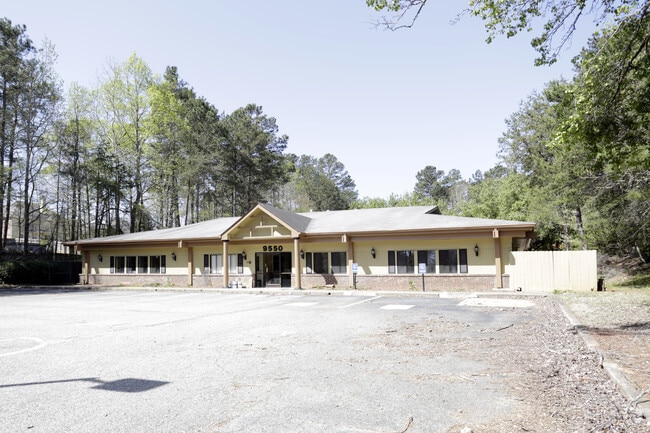
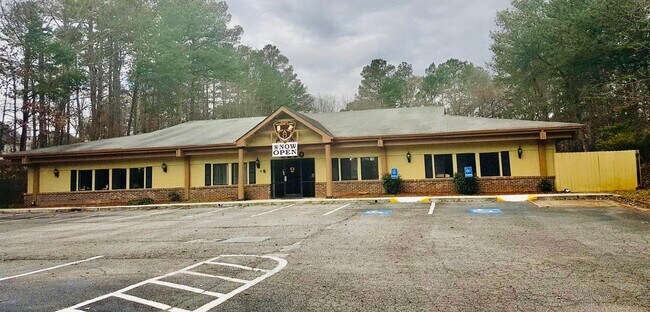
Property Record
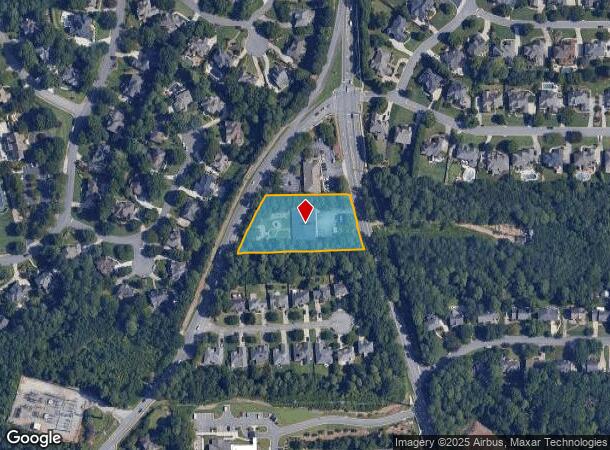
9550 Nesbit Ferry Rd, Alpharetta, GA 30022
NEARBY LISTINGS FOR SALE OR LEASE
Property Detail
9550 Nesbit Ferry Rd
12-2920-0786-070-1
Fulton
Daycare
Georgia
X
786
13121C0068F
1.26 AC
2024
Roswell/Alpharetta
2025
Atlanta
011432
Atlanta-Sandy Springs-Roswell, GA
6,392 SF
DEMOGRAPHICS near 9550 Nesbit Ferry Rd
1 Mile
3 Mile
5 Mile
2024 Total Population
10,098
67,847
200,108
2029 Population
10,254
69,038
204,093
Pop Growth 2024-2029
+ 1.54%
+ 1.76%
+ 1.99%
Average Age
40
40
40
2024 Total Households
3,811
25,850
79,301
HH Growth 2024-2029
+ 1.68%
+ 1.90%
+ 2.13%
Median Household Inc
$110,720
$117,758
$108,143
Avg Household Size
2.60
2.60
2.50
2024 Avg HH Vehicles
2.00
2.00
2.00
Median Home Value
$483,882
$499,778
$482,107
Median Year Built
1988
1988
1988
Nearby Places
Map Layers
Map Styles
 Street
 Aerial
- Restaurants
- Banks
- Shops
- Fitness
- Groceries
PUBLIC TRANSPORTATION
AIRPORT
Hartsfield - Jackson Atlanta International
DRIVE
WALK
Distance
Hartsfield - Jackson Atlanta International
47 min
33.4 mi
Freight Ports
Georgia Ports - Savannah
DRIVE
WALK
Distance
Georgia Ports - Savannah
306 min
269.5 mi
SALE & LEASE HISTORY
LISTING DATE
SALE/LEASE

May 19, 2017
For Lease
May 10, 2017
For Sale
Jan 16, 2020
For Sale
Nearby Properties
Address
Land Use
TOTAL SIZE
Lot Size
Zoning
Address
Land Use
TOTAL SIZE
Lot Size
Zoning
683,219 SF
48.04 AC
R4C
Address
Land Use
TOTAL SIZE
Lot Size
Zoning
9,544,248 SF
74.91 AC
R4
Address
Land Use
TOTAL SIZE
Lot Size
Zoning
4,705,880 SF
8.55 AC
OI
Address
Land Use
TOTAL SIZE
Lot Size
Zoning
415,701 SF
6.75 AC
OI
Address
Land Use
TOTAL SIZE
Lot Size
Zoning
5,892,558 SF
33.38 AC
R4
Address
Land Use
TOTAL SIZE
Lot Size
Zoning
1,672,146 SF
21.21 AC
R4
Address
Land Use
TOTAL SIZE
Lot Size
Zoning
1,159,560 SF
7.12 AC
CUP
Address
Land Use
TOTAL SIZE
Lot Size
Zoning
792,356 SF
20.07 AC
R5
Address
Land Use
TOTAL SIZE
Lot Size
Zoning
1,196,908 SF
30.28 AC
OI
Address
Land Use
TOTAL SIZE
Lot Size
Zoning
1,423,656 SF
15.44 AC
OI
Address
Land Use
TOTAL SIZE
Lot Size
Zoning
2,109,527 SF
70.17 AC
OP
Address
Land Use
TOTAL SIZE
Lot Size
Zoning
666,599 SF
24.20 AC
PSC
Address
Land Use
TOTAL SIZE
Lot Size
Zoning
4,821,900 SF
20.58 AC
R4C
Address
Land Use
TOTAL SIZE
Lot Size
Zoning
510,068 SF
64.18 AC
OPMS
Address
Land Use
TOTAL SIZE
Lot Size
Zoning
367,876 SF
41.40 AC
PSC
Address
Land Use
TOTAL SIZE
Lot Size
Zoning
2,480,205 SF
37.86 AC
C1
Address
Land Use
TOTAL SIZE
Lot Size
Zoning
6,769,095 SF
21.82 AC
OI
Address
Land Use
TOTAL SIZE
Lot Size
Zoning
211,069 SF
14.91 AC
OI
Address
Land Use
TOTAL SIZE
Lot Size
Zoning
1,592,455 SF
21.50 AC
R3
Address
Land Use
TOTAL SIZE
Lot Size
Zoning
1,071,370 SF
22.30 AC
R4
Address
Land Use
TOTAL SIZE
Lot Size
Zoning
1,747,896 SF
36.51 AC
C1C
Address
Land Use
TOTAL SIZE
Lot Size
Zoning
2,849,264 SF
21 AC
OI
Address
Land Use
TOTAL SIZE
Lot Size
Zoning
4,758,628 SF
25.92 AC
R4
Address
Land Use
TOTAL SIZE
Lot Size
Zoning
1,438,388 SF
27.46 AC
OI
Address
Land Use
TOTAL SIZE
Lot Size
Zoning
2,066,346 SF
22.96 AC
R4C
Address
Land Use
TOTAL SIZE
Lot Size
Zoning
879,828 SF
28 AC
PSC
Address
Land Use
TOTAL SIZE
Lot Size
Zoning
1,994,949 SF
14.41 AC
R4C
Address
Land Use
TOTAL SIZE
Lot Size
Zoning
126,630 SF
30 AC
R1
Address
Land Use
TOTAL SIZE
Lot Size
Zoning
115,023 SF
11.77 AC
C3
Address
Land Use
TOTAL SIZE
Lot Size
Zoning
51.89 AC
OI
The World's #1 Commercial Real Estate Marketplace
Connect with us
© 2025 CoStar Group
The information above has been obtained from sources believed reliable. While we do not doubt its accuracy we have not verified it and make no guarantee, warranty or representation about it. It is your responsibility to independently confirm its accuracy and completeness. Any projections, opinions, assumptions, or estimates used are for example only and do not represent the current or future performance of the property. The value of this transaction to you depends on tax and other factors which should be evaluated by your tax, financial, and legal advisors. You and your advisors should conduct a careful, independent investigation of the property to determine to your satisfaction the suitability of the property for your needs.